F
Current Radar or Satellite Image

Flhurricane.com - Central Florida Hurricane Center - Tracking Storms since 1995Hurricanes Without the Hype! Since 1995


The 2024 Atlantic Hurricane Season Begins on June 1st and lasts until Nov 30th. NHC Outlooks resume on May 15th..
Days since last H. Landfall - US: Any 237 (Idalia) , Major: 237 (Idalia) Florida - Any: 237 (Idalia) Major: 237 (Idalia)


Archives 2010s >> 2019 News Talkbacks

Pages: 1
MikeCAdministrator
Admin


Reged:
Posts: 4544
Loc: Orlando, FL
Dorian Finally on the Move
      #100593 - Tue Sep 03 2019 12:42 PM

2:00PM Update September 4 2019
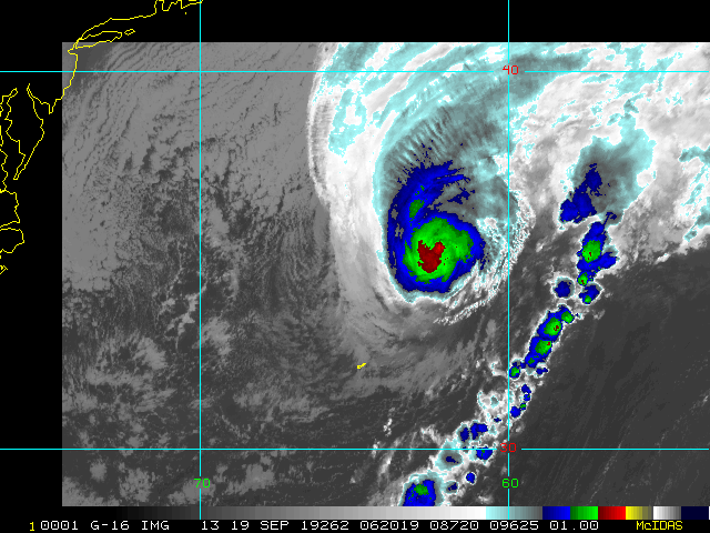
Dorian has made landfall on Hatteras, NC, flooding the outer banks from Ocracoke to Rodanthe and then some. The Canadian Hurricane Center has issued a Hurricane Warning for eastern Nova Scotia from Hubbards to Avonport.

11:00PM Update September 4 2019
Dorian has regained Category 3 hurricane strength.

9:30PM Update September 3 2019
Dorian continues NNW to NW tonight, tracking offshore and usually parallel to the east coast of Florida. This should continue until a couple of shortwaves recurve Dorian to the northeast by Thursday, putting the southeast, and in particular North Carolina, at risk for a direct hit.

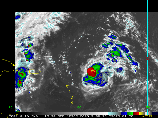
The heart of the season continues with no less than three simultaneous Tropical Cyclones in the Atlantic: Fernand (W Gulf), TD8 (eastern Atlantic), and last but not least Dorian. By this time Thursday there could also be a fourth, as we are keeping an eye out on a new Tropical Wave expected to develop in the far eastern Atlantic and head west.

As a reminder, you can also follow along with more in-depth model discussions and more in the Forecast Lounge. If you can't find a Lounge you are looking for on the main page, simply look for the "Forums" tab (often in a bar on the left or right side of the main page), where you can usually find the very thread you are looking for. If posting to a Lounge, we ask that one refrain from going off-topic, or using unnecessary words. The idea is for us all to stay on point for a given Lounge, and not to delve into hype or wishcasting.
-Ciel

Current Forecast Lounges
Invest 94L Lounge , Tropical Storm Fernand Lounge (E MX/S TX) , Invest 92L Lounge (Bermuda Threat), Hurricane Dorian Lounge


Original Update
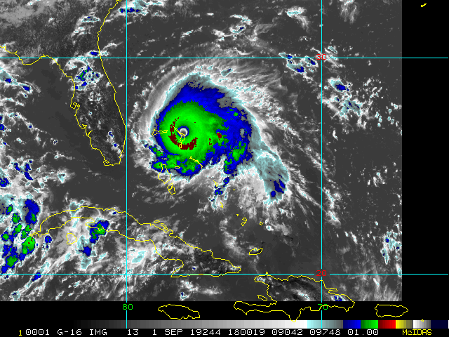
At the 8am advisory slow motion of Dorian to the Northwest has begun at 1mph, shown on the Florida radar, The same slow movement in Bahamas followed by a track close to but offshore of Florida has been forecast since Saturday morning.

Dorian is still impacting Grand Bahama and stationary but expected to begin to move toward the North Northwest later today, meanwhile, Tropical Storm Warnings are up along the northeast coast of Mexico The from La Pesca northward to Barra El Mezquital for newly designated Potential Tropical Cyclone 7 in the Gulf which may landfall as a Tropical Storm in Mexico tomorrow night.

Dorian's lack of forward motion has caused the water beneath it to cool enough to weaken it to a category 3, which is still a major hurricane, and still has the momentum in the waves and surge from being a much stronger storm which increases the storm surge impact along the coast. Dorian's weaker side is on the west, so that is in our favor, but it likely will get close enough to still bring plenty of Tropical Storm force winds and some hurricane force winds to parts of Florida. The size of the windfield has generally expanded.

Dorian's motion based on the forecast track should take it closest to Florida overnight tonight into tomorrow and be up near South Carolina by Thursday, and by North Carolina by early Friday morning. The National Hurricane Center Although the official forecast does not show Dorian making landfall along the Florida east coast, users are reminded not to forecast on the exact forecast track. A relatively small deviation to the left of this track could bring the core of the hurricane near or over the coastline.


http://www.FloridaDisaster.org - Florida Emergency Management Page


Bahamas Radar

East Florida Links <html><a href="http://radar.weather.gov/ridge/Conus/southeast_lite_loop.php" onMouseover="ddrivetip('<img src=\'http://radar.weather.gov/ridge/Conus/Loop/southeast_loop.gif\'>');" onMouseout="hideddrivetip();">Southeast Composite Radar Loop</A>

(<a href="http://radar.weather.gov/ridge/Conus/southeast_lite.php" 

onMouseover="ddrivetip('<img src=\'http://radar.weather.gov/ridge/Conus/RadarImg/southeast.gif\>');" onMouseout="hideddrivetip();">Latest Static</a></html>) South to North:

<html> <a href="https://radar.weather.gov/ridge/lite/K</html>BYW<html>_loop.gif" onMouseover="ddrivetip('<img src=\'https://radar.weather.gov/ridge/lite/K</html>BYW<html>_loop.gif\'>');" onMouseout="hideddrivetip();"></html>Key West, FL Radar<html> Radar Loop</A>

(<a href="https://radar.weather.gov/ridge/lite/K</html>BYW<html>_0.gif" onMouseover="ddrivetip('<img src=\'https://radar.weather.gov/ridge/lite/K</html>BYW<html>_0.gif\'>');" onMouseout="hideddrivetip();">Latest Static</a>)</html>

<html> <a href="https://radar.weather.gov/ridge/lite/K</html>AMX<html>_loop.gif" onMouseover="ddrivetip('<img src=\'https://radar.weather.gov/ridge/lite/K</html>AMX<html>_loop.gif\'>');" onMouseout="hideddrivetip();"></html>Miami, FL Radar<html> Radar Loop</A>

(<a href="https://radar.weather.gov/ridge/lite/K</html>AMX<html>_0.gif" onMouseover="ddrivetip('<img src=\'https://radar.weather.gov/ridge/lite/K</html>AMX<html>_0.gif\'>');" onMouseout="hideddrivetip();">Latest Static</a>)</html>

<html> <a href="https://radar.weather.gov/ridge/lite/K</html>MLB<html>_loop.gif" onMouseover="ddrivetip('<img src=\'https://radar.weather.gov/ridge/lite/K</html>MLB<html>_loop.gif\'>');" onMouseout="hideddrivetip();"></html>Melbourne, FL Radar<html> Radar Loop</A>

(<a href="https://radar.weather.gov/ridge/lite/K</html>MLB<html>_0.gif" onMouseover="ddrivetip('<img src=\'https://radar.weather.gov/ridge/lite/K</html>MLB<html>_0.gif\'>');" onMouseout="hideddrivetip();">Latest Static</a>)</html>

<html> <a href="https://radar.weather.gov/ridge/lite/K</html>JAX<html>_loop.gif" onMouseover="ddrivetip('<img src=\'https://radar.weather.gov/ridge/lite/K</html>JAX<html>_loop.gif\'>');" onMouseout="hideddrivetip();"></html>Jacksonville, FL Radar<html> Radar Loop</A>

(<a href="https://radar.weather.gov/ridge/lite/K</html>JAX<html>_0.gif" onMouseover="ddrivetip('<img src=\'https://radar.weather.gov/ridge/lite/K</html>JAX<html>_0.gif\'>');" onMouseout="hideddrivetip();">Latest Static</a>)</html>


Caribbean/South East Coast Satellite Imagery


SFWMD Radar Loop of South Florida with storm Track


SFWMD Full Florida Radar Loop with Storm Track


Area Forecast Discussions: FLorida Keys - Miami/South Florida - Melbourne/East Central Florida - Jacksonville/Northeast Florida -


Mid-Atlantic/Carolina Links <html><a href="http://radar.weather.gov/ridge/Conus/southeast_lite_loop.php" onMouseover="ddrivetip('<img src=\'http://radar.weather.gov/ridge/Conus/Loop/southeast_loop.gif\'>');" onMouseout="hideddrivetip();">Southeast Composite Radar Loop</A>

(<a href="http://radar.weather.gov/ridge/Conus/southeast_lite.php" 

onMouseover="ddrivetip('<img src=\'http://radar.weather.gov/ridge/Conus/RadarImg/southeast.gif\>');" onMouseout="hideddrivetip();">Latest Static</a></html>)

<html> <a href="https://radar.weather.gov/ridge/lite/K</html>clx<html>_loop.gif" onMouseover="ddrivetip('<img src=\'https://radar.weather.gov/ridge/lite/K</html>clx<html>_loop.gif\'>');" onMouseout="hideddrivetip();"></html>Charleston, SC Radar<html> Radar Loop</A>

(<a href="https://radar.weather.gov/ridge/lite/K</html>clx<html>_0.gif" onMouseover="ddrivetip('<img src=\'https://radar.weather.gov/ridge/lite/K</html>clx<html>_0.gif\'>');" onMouseout="hideddrivetip();">Latest Static</a>)</html>

<html> <a href="https://radar.weather.gov/ridge/lite/K</html>ltx<html>_loop.gif" onMouseover="ddrivetip('<img src=\'https://radar.weather.gov/ridge/lite/K</html>ltx<html>_loop.gif\'>');" onMouseout="hideddrivetip();"></html>Wilmington, NC Radar<html> Radar Loop</A>

(<a href="https://radar.weather.gov/ridge/lite/K</html>ltx<html>_0.gif" onMouseover="ddrivetip('<img src=\'https://radar.weather.gov/ridge/lite/K</html>ltx<html>_0.gif\'>');" onMouseout="hideddrivetip();">Latest Static</a>)</html>

<html> <a href="https://radar.weather.gov/ridge/lite/K</html>mhx<html>_loop.gif" onMouseover="ddrivetip('<img src=\'https://radar.weather.gov/ridge/lite/K</html>mhx<html>_loop.gif\'>');" onMouseout="hideddrivetip();"></html>Morehead City, NC Radar<html> Radar Loop</A>

(<a href="https://radar.weather.gov/ridge/lite/K</html>mhx<html>_0.gif" onMouseover="ddrivetip('<img src=\'https://radar.weather.gov/ridge/lite/K</html>mhx<html>_0.gif\'>');" onMouseout="hideddrivetip();">Latest Static</a>)</html>

<html> <a href="https://radar.weather.gov/ridge/lite/K</html>akq<html>_loop.gif" onMouseover="ddrivetip('<img src=\'https://radar.weather.gov/ridge/lite/K</html>akq<html>_loop.gif\'>');" onMouseout="hideddrivetip();"></html>Norfolk/Wakefield, VA Radar<html> Radar Loop</A>

(<a href="https://radar.weather.gov/ridge/lite/K</html>akq<html>_0.gif" onMouseover="ddrivetip('<img src=\'https://radar.weather.gov/ridge/lite/K</html>akq<html>_0.gif\'>');" onMouseout="hideddrivetip();">Latest Static</a>)</html> 

Area Forecast Discussions: Charleston, SC - Wilmington, NC - Morehead City, NC - Norfolk/Virginia Beach/Hampton Roads, VA

Power Outage Maps: South Carolina Power Outage Map North Carolina Power Outage Map Virginia Power Outage Map


Caribbean Radar Recording

Invest 98L Lounge W Gulf Trof Lounge


E Atlantic Wave (94L?) Lounge
Tropical Storm Fernand Lounge (E MX/S TX)
Invest 92L Lounge (Bermuda Threat)
Hurricane Dorian Lounge

Edited by cieldumort (Sun Sep 15 2019 02:51 PM)


Post Extras: Print Post   Remind Me!   Notify Moderator  
MikeCAdministrator
Admin


Reged:
Posts: 4544
Loc: Orlando, FL
Re: Dorian Finally on the Move [Re: MikeC]
      #100652 - Thu Sep 05 2019 01:58 AM

Recon reports Dorian may be a Cat 3 again, approaching NC tomorrow. 955mb (down from 959mb)


Post Extras: Print Post   Remind Me!   Notify Moderator  
cieldumort
Moderator


Reged:
Posts: 2305
Loc: Austin, Tx
Re: Dorian Finally on the Move [Re: MikeC]
      #100662 - Fri Sep 06 2019 03:13 PM

Dorian is off to the northeast and expected to hit Nova Scocia this weekend while still at Hurricane Force.
Quote:

A Tropical Storm Warning is now in effect east of Bar Harbor,
Maine, to Eastport, Maine.

The Hurricane Warning has been discontinued west of Bogue Inlet,
North Carolina.

SUMMARY OF WATCHES AND WARNINGS IN EFFECT:

A Storm Surge Warning is in effect for...
* Salter Path NC to Poquoson VA
* Pamlico and Albemarle Sounds
* Neuse and Pamlico Rivers
* Hampton Roads

A Hurricane Warning is in effect for...
* Bogue Inlet to the North Carolina/Virginia border
* Pamlico and Albemarle Sounds

A Hurricane Watch is in effect for...
* Nova Scotia

A Tropical Storm Warning is in effect for...
* North Carolina/Virginia border to Fenwick Island DE
* Chesapeake Bay from Drum Point southward
* Tidal Potomac south of Cobb Island
* Woods Hole to Sagamore Beach MA
* Nantucket and Martha's Vineyard MA
* East of Bar Harbor to Eastport ME

A Tropical Storm Watch is in effect for...
* Prince Edward Island
* Magdalen Islands
* Fundy National Park to Shediac
* Francois to Boat Harbour


--------------------
Fully vaccinated as of May 2021
(Moderna x2)


Post Extras: Print Post   Remind Me!   Notify Moderator  
Pages: 1


Extra information
0 registered and 0 anonymous users are browsing this forum.

Moderator:  

Print Topic

Forum Permissions
      You cannot start new topics
      You cannot reply to topics
      HTML is disabled
      UBBCode is enabled

Rating:
Topic views: 10045

Rate this topic

Jump to

Note: This is NOT an official page. It is run by weather hobbyists and should not be used as a replacement for official sources. 
CFHC's main servers are currently located at
Hostdime.com in Orlando, FL.
Image Server Network thanks to Mike Potts and Amazon Web Services. If you have static file hosting space that allows dns aliasing contact us to help out! Some Maps Provided by:
Great thanks to all who donated and everyone who uses the site as well. Site designed for 800x600+ resolution
When in doubt, take the word of the National Hurricane Center