cieldumort
Moderator

Reged:
Posts: 2712
Loc: Austin, Tx
|
|

Image cr. National Weather Service Climate Prediction Center
An active Central American Gyre pattern, as has helped give rise to our first Invest of the year (first for both the Atlantic and the East Pac, even), shows no signs of going away or winding down any time soon, and by the middle of next week conditions look to become increasingly favorable for development either just on the East Pac side of southeastern Mexico - and potentially crossing over into the Bay of Campeche (BoC) from around the Gulf of Tehuantepec, whether intact or reforming - or forming in the western Gulf outright.
The preponderance of trustworthy models and their ensemble members suggest a roughly 50/50 chance of a TD or named storm in this region next week, that would then be landlocked.
Given the strength of the signal, we are starting a lounge for this section of the Central American Gyre at this time. Should an Invest or named storm be assigned as several models generally advertise, the title of this Lounge will be updated accordingly.
Title changed to Yucatan Low Pending Invest # with today's 6/16 update. Most likely this feature will be tagged Invest 91L within the next 24 hours and the title will be updated again accordingly.
Assigned 91L the morning of 06/17. Title has been updated.
6/17/24 3pm CT. Watches and Warnings likely at any time for Storm 01L - Ciel
|
cieldumort
Moderator
Reged:
Posts: 2712
Loc: Austin, Tx
|
|
Many operational models and plenty of their ensemble members continue to forecast the development of a tropical cyclone in the western Gulf during the week of June 17th. Now that this time frame has drawn closer, we are starting to be able to make out some of the details a little better, and not just with the models, but with our own eyes.
Conditions for development are dramatically rising in not only the western Gulf, but also the northwestern Caribbean. There is now even an outside chance of development as soon as later this weekend and also as potentially as far east as the NW Carib. Even without a bona fide TC, the odds of a significant tropical heavy weather maker is already close to guaranteed. Invest 90L was born and began seriously affecting Florida ahead of model forecasts. This may also be the case with what is likely to become our next Invest, (91L).
As of 2pm EDT Friday June 14, is now assigning 50% odds of development within 7 days in the western Gulf, 0% within 48 hours. It seems almost certain to see both numbers go up by Sunday morning, and possibly by a lot.
Here are a few model forecasts from 12Z and 06Z today
14/12z Runs
ECMWF - Closed 1002mb tropical low (possibly a TD) by Tuesday morning (06/18). 999mb low just east of Tampico, MX Thursday morning.
GFS - 998mb tropical low (possibly closed/TD) by midday Tuesday (06/18) in the southern Bay of Campeche. 996-998mb likely closed tropical low (TD/TS) preparing to make landfall in southwestern Bay of Campeche.
GDPS - No real development in NW Carib or SW Gulf from this, but does recognize an enhanced area of spin and disturbed weather.
ICON - Elongated 1006mb low by Sunday morning (06/16) in the southern Bay of Campeche. No TC genesis but weather to MX and TX.
14/06 Runs
ECMWF AIFS (Artificial Intelligence Integrated Forecasting System) - 1005mb tropical low off the coast of southern Belize Sunday night. Tracks NW across the Yucatan. 1002mb closed low (probable TD/TS) Tuesday morning in the western Gulf. Comes ashore around Corpus Christi, TX Wednesday evening as a possible TD.
None of these runs advertise an alarming wind threat, but the rainfall could be copious and a great many details have yet to be teased out. Having recon missions into this region will be especially informative.
|
cieldumort
Moderator
Reged:
Posts: 2712
Loc: Austin, Tx
|
|
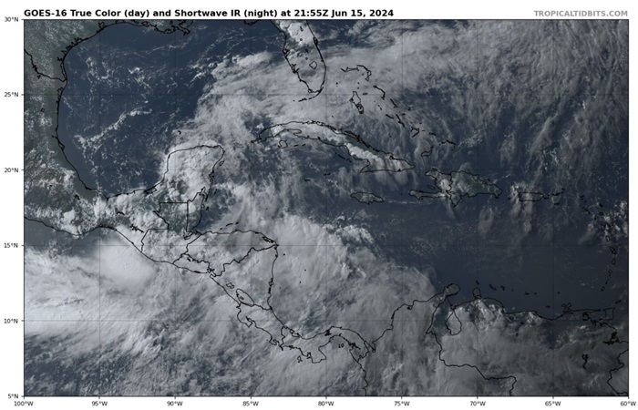
Above: Parent Central American Gyre June 15, 2024 2155z Image cr. Tropical Tidbits
Central American Gyre has once again become prominent in the region and its relative strength may complicate the ability of would-be-Invest-91L-in-the-Bay-of-Campeche to become a tropical cyclone, or should it do so, possibly have its track bent back towards extreme southern Mexico and central America contrary to most model runs.
CAG-born TCs are notoriously challenging to predict, and alternatively expected disturbance Invest 91L could even begin in the NW Caribbean, or even further north around Texas. There also remains an outside chance of TC genesis over the extreme East Pac that then crosses over into the W Atlantic, and even still no 91L at all (while least likely outcome).
Lots in play and "91L"'s initial location, interaction with parent CAG as well as other CAG vorts and even possible other TCs will have a ton of influence on its ultimate organization and track. Unsurprisingly, model consensus today appears to be breaking down some. It might not be until early next week that there is clarity. Meanwhile, Central America, southern/eastern Mexico, Texas and Louisiana are all likely to see greater or lesser impacts, with flooding rains the greatest risk over all.
|
cieldumort
Moderator
Reged:
Posts: 2712
Loc: Austin, Tx
|
|
Recon is back in 01L presently.
Models have really consolidated around this hook left into Mexico whether or not 01L decisively becomes a tropical cyclone. There may have been some trend of the system today to begin organizing a tad north and east of where earlier model runs expected it to be, so that may call into question how much this consensus should be relied upon, but either way, the system will be sprawling, and the exact point of landfall is almost a moot point as far as impacts.
Something else to watch for is how much tug 01L may feel into the deeper convection. At the moment, there is a bit of balance in that deeper convection is primarily to the north and south of the approximate center, with some also a bit northwest and east-southeast. Should one or two quadrants dominate, that might induce a bit of pull bias, although probably not all that much, given its extreme size.
NHC has also mentioned that the model trackers look to be faster than believable, and has set the official forecast track slower than deterministic and consensus trackers. If this call bears out, it is also conceivable that the system has some more time over water than some modeling would otherwise imply.
0z runs out tonight with more recon data to work with. Could be enlightening.
|
cieldumort
Moderator
Reged:
Posts: 2712
Loc: Austin, Tx
|
|
And so the Eastern Pacific may have a named system in it this month just yet ... except perhaps not the 'A' name they were expecting
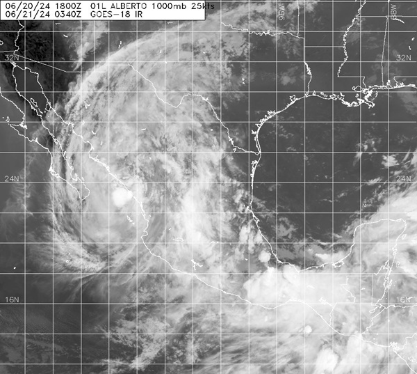
Astounding staying power in no small part owing to his very large size, Alberto retains some circulation heading across Mexico and about to emerge into the Eastern Pacific predawn Friday June 21, 2024.
|
|


 Threaded


