cieldumort
Moderator

Reged:
Posts: 2664
Loc: Austin, Tx
|
|
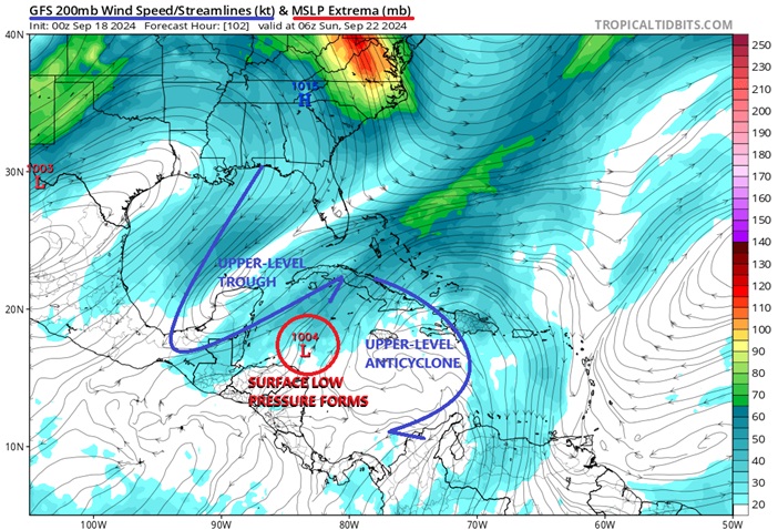
As has been noted in the General Long Range Forecast Lounge, modeling has been trending warmer and warmer on the development of a Central American Gyre over this coming weekend that spins up an Atlantic side TC early next week.
As of 9/18/0z, global modeling is plenty compelling enough to start a lounge on this as-of-yet, only modeled system.
Central American Gyres are large, closed areas of low pressure that have two peak seasons: May through June, and then again September through November. As their name suggests, they are roughly centered over Central America.
There are two distinct types of CAGs: nonbaroclinic and baroclinic. Nonbaroclinic CAGs are by far the most common and are associated with an upper-level high. Baroclinic CAGs are far less common, and are characterized by an upper-level trof. The exact type of CAG can have large implications for the future location of TC genesis and track of any TC born from the parent broad area of low pressure. Most baroclinic CAGs form well north of where of where most nonbaroclinic CAGs do. Both types produce very heavy to extreme rainfall events, particularly along the Central American coastline.
Over this coming weekend, an upper-level trough will drop far south into the GOM, forcing rising air across the western Caribbean and lowering pressures generally throughout this region, especially near or along our seemingly ever-present quasi-stationary coastal front, which itself is expected to slide into Central America and the northwestern Caribbean by then. By early next week, this ULL is likely to split, allowing an upper-level anticyclone to track further west and possibly colocate with the nascent area of surface low pressure near or over Central America, thus further increasing the potential for tropical cyclone genesis or perhaps already by this time, just increasing favorable conditions for continued strengthening.
Should the above play out as now most global models prognosticate, an area of tightening low pressure, possibly a TC, will be forming on the eastern to northeastern side of the CAG or along/just south of the front, likely in the northwestern Caribbean, with steering currents that might favor a north to northeast track.
Alternate solutions range from development more along the north to northwestern portion of the CAG (far less likely, but possible), only East Pac TC development (also far less likely, but possible), and no TC development at all (less likely, but somewhat possible).
ECMWF ensemble implied TC development odds in the western to northwestern Caribbean over the next 10 days are already over 70%.
As of 9/18/24 1:30AM EDT, the date and time of original entry, this area of low pressure is only a modeled forecast, and does not yet have an Invest tag. Should a disturbance form from this that does get Invest tagged, the title will be updated accordingly.
This developing system has just been Invest tagged today, Sep 22, and the title has been updated accordingly.
2024-09-22 18:00 15.3 -83.2 20
Official Advisories on now Potential Tropical Cyclone NINE have begun as of 11AM EDT Sep 23 and the title has been updated accordingly.
Tropical Storm Helene 2024-09-24 18:00 19.4 -84.6 40
Ciel
Edited by cieldumort (Tue Sep 24 2024 03:41 PM)
|
cieldumort
Moderator
Reged:
Posts: 2664
Loc: Austin, Tx
|
|
0z models are coming in hot tonight. We still do not have even as much as a broad area of low pressure, let alone Invest or depression, so all of this should be taken with a pound of salt. However, conditions in the NW Caribbean and Gulf next week could be extraordinarily favorable for anything that wants to and does form.
19/0z Globals
GFS: Apparent TD or monsoon depression in the NW Caribbean by 12Z Tuesday. Tropical Storm in NW Caribbean by 0z Wednesday. Cat 1 by 12Z Wednesday in NW Caribbean tracking northwest. Cat 2/3 by 06Z Thursday in the Yucatán Channel, tracking northwest. Begins slowing down and gradually rounding more to the north and probably Cat 4 by 12Z Friday in the southern Gulf of Mexico. Maintains Cat 4+/- into Saturday while slowly tracking north, while also now a large high-end Major. This is potentially a wrecking ball of a surge-maker at this point. 0z Monday 30th, Tropical Storm conditions begin battering the coasts of eastern Louisiana, Mississippi, Alabama and westernmost Florida panhandle. Begins feeling the tug to the northeast and a landfall somewhere around Port St. Joe, Florida predawn Tuesday the 1st of October as a 959+/-mb large hurricane with some probably very significant storm surge. Cuts across north Florida/SE Georgia and plops offshore of South Carolina Tuesday afternoon, tracking northeast just offshore.
ICON: Seems to delay TC genesis to predawn Tuesday Sep 24, tracking wnw across the Yucatán and into the Bay of Campeche, heading towards eastern Mexico through the end of run. Still over water at the end of run at 12Z Thursday Sep 26, never stronger than a tropical storm up to this point.
GDPS: Apparent TD or monsoon depression off the coast of Nicaragua/Honduras 12Z this coming Monday. Sloppy Tropical Storm by 12Z Tuesday in the NW Caribbean, tracking north-northwest. In the Yucatán Channel 06Z Wednesday Cat 1. Large Cat 1/2 in the east-central Gulf 06Z Thursday. Landfall as a large apparent Cat 2 somewhere about the far western Fl panhandle Thursday afternoon/night.
|
cieldumort
Moderator
Reged:
Posts: 2664
Loc: Austin, Tx
|
|
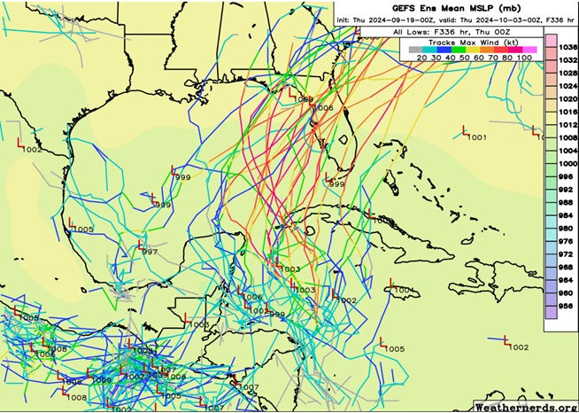
0z/19 Ensemble members by and large are fairly stout and mostly cluster around a track towards Florida. Several members however delay development and/or stay weak, with a track more towards the western Gulf.
|
cieldumort
Moderator
Reged:
Posts: 2664
Loc: Austin, Tx
|
|
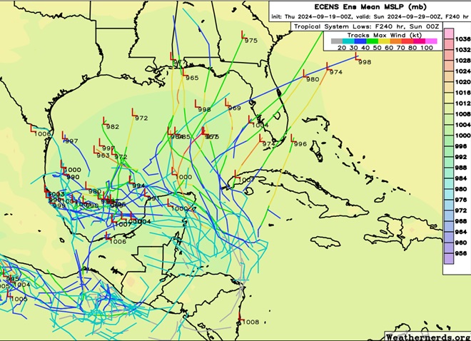
Unlike the 0z ensembles, the 0z shows a large spread, with perhaps some signal for delayed development and an overall greater risk for the western to central Gulf. Florida is still well in the mix.
|
cieldumort
Moderator
Reged:
Posts: 2664
Loc: Austin, Tx
|
|
Today's 12Z and ensembles are somewhat similar to yesterday's with the GEFS favoring earlier and more easterly development and subsequent stronger TCs that trend into the north to northeastern Gulf, and the ECENS development still a bit more delayed with a bias towards the northern to western Gulf. But, there is also arguably more of a shifting of the ensembles towards the members and not the other way around.
9/20/12z members
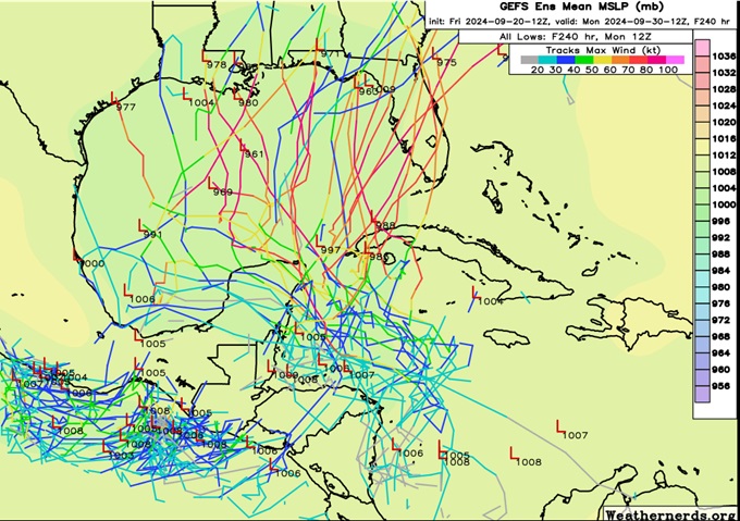
9/20/12z members
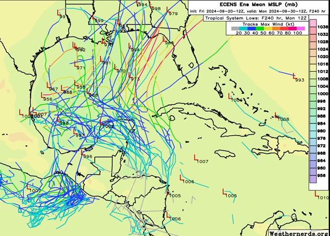
It is my personal read of the layout that should there be TC genesis out of this, which I would place at about 90% odds within 7 days (presently 50% ), it will most likely occur along or east of the eastern coasts of Central America and/or the Yucatán, possibly as far north as the Yucatán channel region, whereas the still advertises several solutions, including the operationals, developing a TC in the southwestern Gulf.
Just where TCG occurs is likely to have an outsized influence on future track and intensity.
|
IdaliaJackson
Verified CFHC User

Reged:
Posts: 18
|
|
Quote:
As has been noted in the General Long Range Forecast Lounge, modeling has been trending warmer and warmer on the development of a Central American Gyre over this coming weekend that spins up an Atlantic side TC early next week.
As of 9/18/0z, global modeling is plenty compelling enough to start a lounge on this as-of-yet, only modeled system.
Central American Gyres are large, closed areas of low pressure that have two peak seasons: May through June, and then again September through November. As their name suggests, they are roughly centered over Central America.
There are two distinct types of CAGs: nonbaroclinic and baroclinic. Nonbaroclinic CAGs are by far the most common and are associated with an upper-level high. Baroclinic CAGs are far less common, and are characterized by an upper-level trof. The exact type of CAG can have large implications for the future location of TC genesis and track of any TC born from the parent broad area of low pressure. Most baroclinic CAGs form well north of where of where most nonbaroclinic CAGs do. Both types produce very heavy to extreme rainfall events, particularly along the Central American coastline.
Over this coming weekend, an upper-level trough will drop far south into the GOM, forcing rising air across the western Caribbean and lowering pressures generally throughout this region, especially near or along our seemingly ever-present quasi-stationary coastal front, which itself is expected to slide into Central America and the northwestern Caribbean by then. By early next week, this ULL is likely to split, allowing an upper-level anticyclone to track further west and possibly colocate with the nascent area of surface low pressure near or over Central America, thus further increasing the potential for tropical cyclone genesis or perhaps already by this time, just increasing favorable conditions for continued strengthening.
Should the above play out as now most global models prognosticate, an area of tightening low pressure, possibly a TC, will be forming on the eastern to northeastern side of the CAG or along/just south of the front, likely in the northwestern Caribbean, with steering currents that might favor a north to northeast track.
Alternate solutions range from development more along the north to northwestern portion of the CAG (far less likely, but possible), only East Pac TC development (also far less likely, but possible), and no TC development at all (less likely, but somewhat possible).
ECMWF ensemble implied TC development odds in the western to northwestern Caribbean over the next 10 days are already over 70%.
As of 9/18/24 1:30AM EDT, the date and time of original entry, this area of low pressure is only a modeled forecast, and does not yet have an Invest tag. Should a disturbance form from this that does get Invest tagged, the title will be updated accordingly.
Bro why are they becoming less enthusiastic
Any chance of Idalit 2.0?
Edited by cieldumort (Sat Sep 21 2024 07:56 PM)
|
MikeC
Admin
Reged:
Posts: 4811
Loc: Orlando, FL
|
|
Morning Run goes into Destin as a cat 3 thursday night, so there's not a lot of time if that occurs, ensembles are spread all over the entirety of Florida from weak to strong. So it appears it's likely to be some sort of Florida impact. Weak or strong, it's going to cause impacts. Flooding and surge for sure, how much beyond that is still in question.
0z Euro is east of the 6z run, 0z Canadian is similar to , but both of those are weaker. 0z Icon was clsoer to where 0z Euro was, (Alligator point/south of Tallahassee)
UKMet has a landfall in Cedar Key.
|
IsoFlame
Weather Analyst

Reged:
Posts: 411
Loc: One block off the Atlantic Oce...
|
|
It's a crapshoot at this time on ultimate intensity/landfall location. Given the environmental conditions present in the eastern GOMEX, rapid intensification on approach to land is probably a given.
--------------------
CoCoRaHS Weather Observer (FL-VL-42) & Surf Forecaster: https://www.surf-station.com/north-florida-surf-forecast-3/
Edited by IsoFlame (Sun Sep 22 2024 07:48 AM)
|
bob3d
Weather Hobbyist

Reged:
Posts: 65
Loc: Pasco County, Florida
|
|
Quote:
It's a crapshoot at this time on ultimate intensity/landfall location. Given the environmental conditions present in the eastern GOMEX, rapid intensification on approach to land is probably a given.
I agree that rapid intensification is likely.
I've seen in the various 9/22/2024 models projecting landfalls anywhere from Destin in the panhandle down to Cedar key. A possible Cat 3 hitting the big bend area of Florida would cause a lot of problems.
--------------------
bob
Time in West Central Florida: 52 years
|
MikeC
Admin
Reged:
Posts: 4811
Loc: Orlando, FL
|
|
Last two runs (12z and 18Z) show a major (cat 4) impact on the Florida Panhandle, then it rapidly moving inland, with it maintaining hurricane strength almost into Tennessee/North Caroilna. (Cat 2 winds over Atlanta). Euro is less, Icon has shifted east toward Steinhatchee, but not as strong. If the is anywhere close to accurate, folks won't have a lot of time to prepare, as it shows landfall early evening Thursday.
|
IsoFlame
Weather Analyst
Reged:
Posts: 411
Loc: One block off the Atlantic Oce...
|
|
Quote:
Last two runs (12z and 18Z) show a major (cat 4) impact on the Florida Panhandle, then it rapidly moving inland, with it maintaining hurricane strength almost into Tennessee/North Caroilna. (Cat 2 winds over Atlanta). Euro is less, Icon has shifted east toward Steinhatchee, but not as strong. If the is anywhere close to accurate, folks won't have a lot of time to prepare, as it shows landfall early evening Thursday.
GFS has been consistently bullish (early on) with intensity and track. Other models starting to get onboard. 18Z has a 940 mb (+/-5 mb) Cat 4 landfalling between Carabelle and Panacea Thursday late. Met a real nice couple vacationing at the condo here in DBS that I work at part time and while talking about all the damage the condo sustained from Ian and Nicole (repair work ongoing 2 years/ 2.5 million $ later) found out they recently resettled to Panacea with a view of the Gulf and have never been through a major. I'm worried for what they may be facing if latest is right.
--------------------
CoCoRaHS Weather Observer (FL-VL-42) & Surf Forecaster: https://www.surf-station.com/north-florida-surf-forecast-3/
Edited by IsoFlame (Sun Sep 22 2024 07:13 PM)
|
MikeC
Admin
Reged:
Posts: 4811
Loc: Orlando, FL
|
|
Closest frame to first landfall on all the hurricane models, all reach major, HWRF gets to 927mb before landfall. HMON is the furtheast east, with a Crystal River, FL landfall:
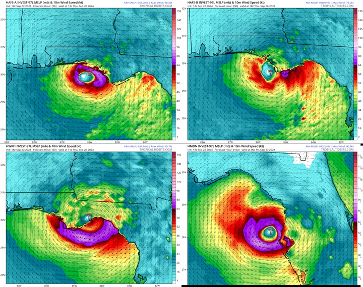
FULL SIZE
Edited by cieldumort (Sun Sep 22 2024 09:23 PM)
|
cieldumort
Moderator
Reged:
Posts: 2664
Loc: Austin, Tx
|
|
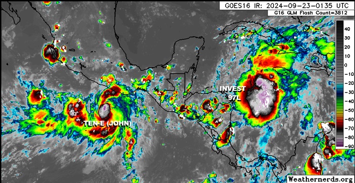
Modeling and the have done a mixed job handling TD TEN-E in the far eastern Pacific. This tropical cyclone, which may already be knocking on the door of high-end Tropical Storm and soon hurricane at the going rate, could potentially blast developing 97L with some shear that is not currently anticipated. Additionally, with such a now strong vortex, there may be some competition for both lower-level vorticity and moisture.
|
MikeC
Admin
Reged:
Posts: 4811
Loc: Orlando, FL
|
|
0z icon shows a cat 1/2 landfall near St. Pete. 0z Shifted right to near Steinhatchee or Perry Fl as a low end Category 4 Thursday evening, then manages to move so fast it is still basically at cat 3 strength over Atlanta, and even a cat 1 over Eastern Tennessee. Large, fast moving, storm with the as well. If it goes to Perry like the shows Tampa would still get cat 1 hurricane force wind and surge.
|
cieldumort
Moderator
Reged:
Posts: 2664
Loc: Austin, Tx
|
|
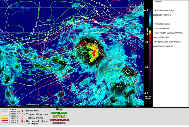
There is arguably a little more westerly shear than analyzed by CIMSS impinging on 97L tonight. This shear may indeed be getting enhanced from the outflow of now Tropical Storm John, which by many measures, could already be a 40-50 knot storm.
What using standard IR imagery might look like the "outer center" of 97L is really nothing more than a line of thunderstorms associated with what is probably its mid-level low, that has actually been getting bowed out towards the east.
Nonetheless, this near-term impediment may not last. East Pac Tropical Storm John looks like it could end up staying far enough west to have only minimal, temporary and/or transient negative impacts on 97L's future intensity. Ideally we will get recon passes into both systems later today or at latest tomorrow (Tuesday) and have a much clearer picture of this interaction.
|
MikeC
Admin
Reged:
Posts: 4811
Loc: Orlando, FL
|
|
0z euro strong Cat 1 appalachicola, cat 2 to Alligator Point, all thursday afternoon/evening, and 6z with a cat 4 to Steinhatchee Thursday night.
HMON Cat 4 borderline 5 to spring Hill, HWRF Cat 5 to Just east of St. Marks (near Tallahassee), HAFS A Cat 5 to Apalachicola, HAFS B Cat 5 (913mb) to Apalachicola
|
MikeC
Admin
Reged:
Posts: 4811
Loc: Orlando, FL
|
|
6z hurricane models, HMON shifted west/left a little toward Steinhatchee as a cat 4, keeps a little more of the bad stuff away from Tampa here. HAFS-A is a little right/east with landfall near St. Marks in the Big Bend as a cat 4/5, HAFS-B is also a little right/east with a cat 5 landfall near St. George's Island (just east of Appalachicola), HWRF run not complete yet
|
bob3d
Weather Hobbyist
Reged:
Posts: 65
Loc: Pasco County, Florida
|
|
https://www.youtube.com/watch?v=AMZ3wr-_Cvc
Good discussion regarding potential Hurricane Helene.
--------------------
bob
Time in West Central Florida: 52 years
|
IsoFlame
Weather Analyst
Reged:
Posts: 411
Loc: One block off the Atlantic Oce...
|
|
Quote:
https://www.youtube.com/watch?v=AMZ3wr-_Cvc
Good discussion regarding potential Hurricane Helene.
FOX weather is calling PTC#9 a significant Category 2/borderline major hurricane based on latest modeling. That may be an understatement.
Soon to be Helene could become a "potentially historic" large/catastrophic hurricane at landfall given the favorable environmental conditions that currently are forecast. Dry air entrainment from the N/NW could be an inhibiting factor.
--------------------
CoCoRaHS Weather Observer (FL-VL-42) & Surf Forecaster: https://www.surf-station.com/north-florida-surf-forecast-3/
|
cieldumort
Moderator
Reged:
Posts: 2664
Loc: Austin, Tx
|
|
With the benefit of recon starting to investigate PTC NINE, I've seen just enough to put out my first best guess as to NINE's maximum lifetime intensity.
Invest/PTC Only (Presently): 0%
Tropical Depression <40 MPH: 0%
Tropical Storm 40-45 knots: <1%
Tropical Storm 50 knots: <1%
Tropical Storm 60 knots: 2%
Cat 1 Hurricane: 3%
Cat 2 Hurricane: 14%
Cat 3 Hurricane: 18%
Cat 4 Hurricane: 30%
Cat 5 Hurricane: 32%
Or looked at another way, about a 3% chance of not becoming a hurricane of any category and about a 97% chance of becoming at least a Cat 1 hurricane. An 80% chance of becoming a Major Hurricane (Cat 3, 4 or 5), and a 62% chance of becoming a high-end Major (Cat 4 or 5).
|


 Threaded


