MikeC
Admin
Reged:
Posts: 4835
Loc: Orlando, FL
|
|
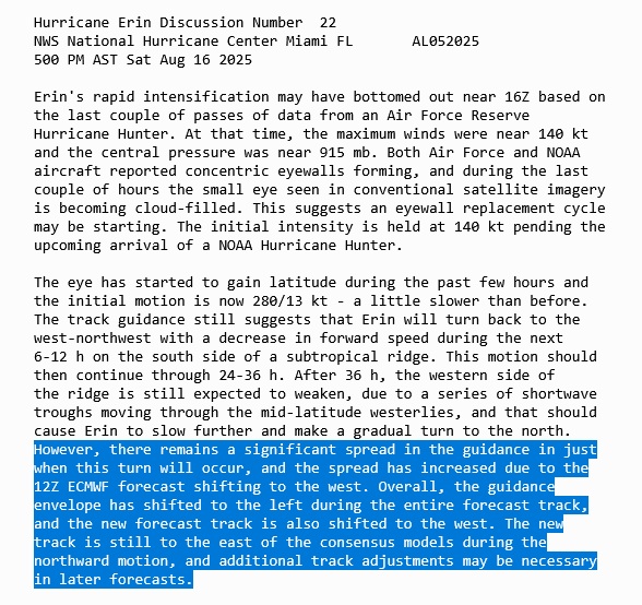
12z models are likely going to a bit off based on how rapidly the situation changed with Erin this morning, later runs may have caught up more. However, the major pattern hasn't changed, maybe shifted left some. Important to watch this though.
|
MikeC
Admin
Reged:
Posts: 4835
Loc: Orlando, FL
|
|
12z Icon, Euro, and the UKMet are all showing tropical storm force winds along the outer banks when it gets up there. is still east of it. None of them had intensity correct, however.
|
cieldumort
Moderator

Reged:
Posts: 2727
Loc: Austin, Tx
|
|
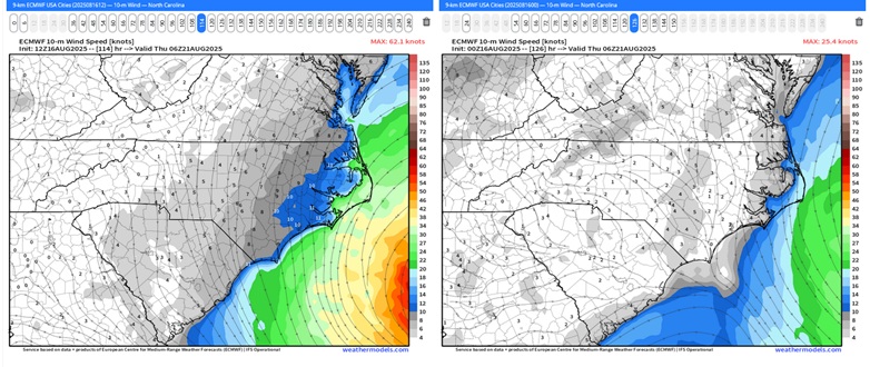
Today's 12Z vs 0z for Thursday 8/21/25 0z
This would bring very rough, truly life-threatening surf conditions to the OBX, to say nothing of the chance of a further westward adjustment wrt the wind.
|
cieldumort
Moderator
Reged:
Posts: 2727
Loc: Austin, Tx
|
|
NHC explicitly advertising that further forecast cone adjustments to the west may be coming
|
cieldumort
Moderator
Reged:
Posts: 2727
Loc: Austin, Tx
|
|
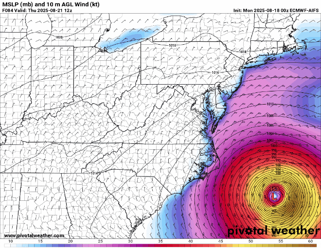
As Erin keeps expanding, the radius of tropical storm force and hurricane force winds have a good chance of being considerably larger than depicted in the models below. Waves and potentially coastal flooding may also be more significant than these runs suggest.
AIFS, , GDPS, , GraphCast , ICON, NAM, RDPS, RRS A, UKMET
Valid Thursday 8/21/12z
|
Bloodstar
Moderator

Reged:
Posts: 468
Loc: Tucson, AZ
|
|
I have found it fascinating watching the model output consistently nudge west. And are my eyes deceiving me or has the storm really slowed down, almost like it's drifting NNW right now.
Just remarking, nothing rigorous right now.
--------------------
M. S. Earth and Atmospheric Sciences, Georgia Tech - May 2020
U. Arizona PhD Student
|


 Threaded

 [Re:
[Re: 

