cieldumort
Moderator

Reged:
Posts: 2738
Loc: Austin, Tx
|
|
A stout wave about to roll off westernmost Africa and into the far eastern Atlantic has had some fairly consistent model support for genesis and a track that takes it far westward, and we are now starting a Lounge on this feature at this time*
Some of the very big players in the ability of a Tropical Wave to develop and continue west are all in a favorable state right now. The Madden-Julian Oscillation (MJO), Convectively Coupled Kelvin Wave (CCKWs) and more are all in nearly ideal positions to support more TC genesis and intensification across the basin at this time, to say nothing of very warm SSTs out in the western Atlantic (See Erin). Higher pressure to the north of the waves tracking westward from Africa has been setting in, keeping them on that westward trajectory.
*The wave now exiting western Africa may or may not meld with a lead wave that is currently floundering. Some runs combine these two into one, others primarily keep the exiting wave dominant and isolated from the lead wave.
Earlier today, Aug 21, the northern portion of the broad trof/wave we have been tracking since its exit from Africa has been Invest-tagged, 90L, and the title has been updated accordingly. The robust southern lobe is now starting to track through northern South America and could reemerge in the southwestern Caribbean. Should that portion show signs of development a new Lounge may be opened up just for it
2025-08-21 12:00 90L 17.1N 55.5W 25 KTS
2025-08-23 18:00 Fernand 26.6N 61.7W 35 KTS
Ciel
Edited by cieldumort (Sat Aug 23 2025 04:05 PM)
|
IsoFlame
Weather Analyst

Reged:
Posts: 414
Loc: One block off the Atlantic Oce...
|
|
Other than anticipating the huge surf from Erin, I'm laser-focused on this one. For several days has consistently suggested it will track further west and become a strong hurricane that will directly impact Florida- either the east coast or the keys- in about 11 days. Latest run took it across the southern tip of the peninsula into the eastern GOMEX with landfall as a 944 mb major near Mobile.
--------------------
CoCoRaHS Weather Observer (FL-VL-42) & Surf Forecaster: https://www.surf-station.com/north-florida-surf-forecast-3/
|
cieldumort
Moderator
Reged:
Posts: 2738
Loc: Austin, Tx
|
|
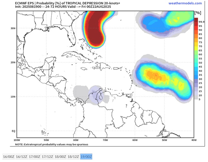
NHC has introduced a possibly conservative 20% on this feature to the 8PM 7-Day tonight.
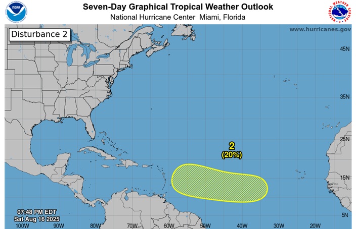
2. Central Tropical Atlantic:
An area of low pressure could form over the central tropical Atlantic during the middle to latter portion of next week from a westward moving tropical wave. Some subsequent development could occur as the system moves westward to west-northwestward at around 15 mph.
* Formation chance through 48 hours...low...near 0 percent.
* Formation chance through 7 days...low...20 percent.
|
MikeC
Admin
Reged:
Posts: 4835
Loc: Orlando, FL
|
|
There are still a lot of obstacles ahead for this wave, something to watch to a degree, but it''s probably a little over 50/50 on staying out to sea, although the Caribbean may need to watch. Things could change quickly either direction with it.
|
MikeC
Admin
Reged:
Posts: 4835
Loc: Orlando, FL
|
|
Overnight models, particularly the ensembes are showing the majority making landfall somewhere (Gulf to Canada) as well as many getting close to the Caribbean islands. Much less of a chance for out to sea today, but too far out to narrow much more than that right now.
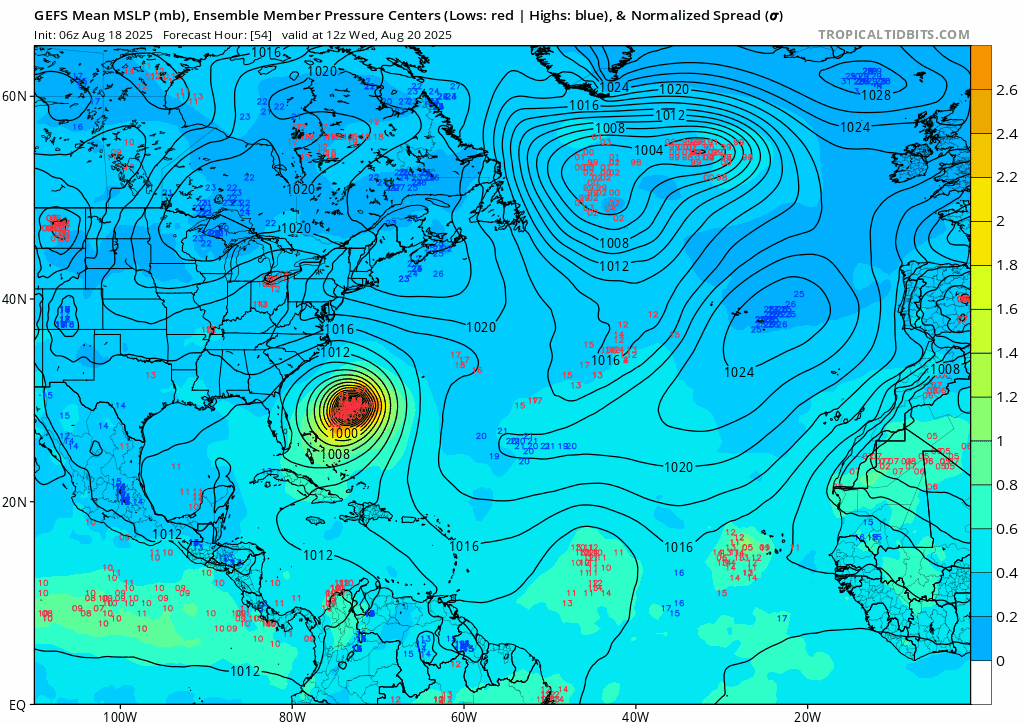
Important to monitor trends on this one. Caribbean especially in the nearer term.
On the flipside, and a few ensembles are really the only models developing it. The Euro, Canadian, Icon, and UKMet do NOT develop this wave.
Edited by CFHC (Mon Aug 18 2025 02:50 PM)
|
cieldumort
Moderator
Reged:
Posts: 2738
Loc: Austin, Tx
|
|
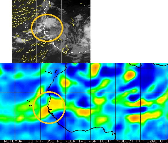
A broad area of low pressure is now taking shape in the eastern Atlantic, comprised of a tropical wave with the axis centered near 32W 12N interacting with a now rolling up of the monsoon trof in response. Two significant areas of spin are evident in conventional radar as well as winds at the surface, as can be seen from the screenshot above (Cr. Weathernerds.com) from 1525z today, with the dominant feature being the wave in the middle.
Given its size and the less than ideal conditions for development over the next few days, odds favor delayed development and thus a further westward track, vs. early development with a greater chance of heading out to sea.
|
MikeC
Admin
Reged:
Posts: 4835
Loc: Orlando, FL
|
|
18Z does a graze of the OBX. One thing to point out the low is elongated with 2-3 potential vortices. These type of systems are usually fighting inside and don't develop until one takes over, if the northern one "wins" euro and recurve is more likely, if the southerly one wins, it's more likely to flow west. It's not going to be straightforward to follow, nor anywhere near as organized as Erin was in the near to mid range.
|
cieldumort
Moderator
Reged:
Posts: 2738
Loc: Austin, Tx
|
|
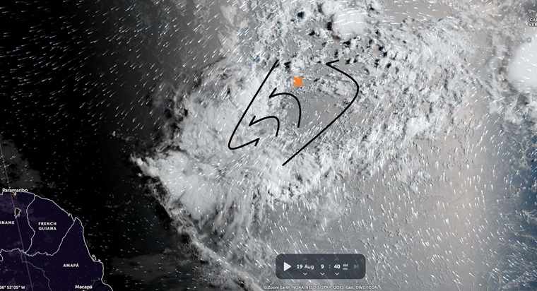
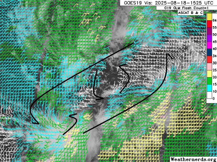
Above: IR Satellite and wind data. Map cr: Zoom Earth 8/19/25/940z
Satellite imagery and model-assisted wind data strongly suggest that a CoC is forming in the southern lobe, well to the southwest of where is tracking this feature (Denoted by the orange "X").
Overnight, a more robust and possibly now dominant circulation looks to have taken shape in association with the deep convection well to "X"'s southwest. Should this trend continue, a substantial relocating of this disturbance would be forthcoming along with likely an Invest tag. Development in the southern lobe portion of the broad monsoonal trof would have significant implications for track, potentially putting the Caribbean islands much more in play.
|
MikeC
Admin
Reged:
Posts: 4835
Loc: Orlando, FL
|
|
None of the models are showing the southerly route this morning, and the disorganized structure makes me think chances will start dropping for this wave today. Even the ensembles have dropped off considerably.
Invest 99L behind it actually could develop, but it would probably be short lived.
|
cieldumort
Moderator
Reged:
Posts: 2738
Loc: Austin, Tx
|
|
I'm left wondering if the operationals have some catching up to do with the reality of a stronger southern lobe.
0z ensembles seem to be honing in on the southwestern lobe and taken together have implied roughly 75% odds of formation within 72 hours as this portion tracks WNW-NW towards the Leewards.
|
Robert
Weather Analyst

Reged:
Posts: 371
Loc: Southeast, FL
|
|
I think we're not seeing something here, every model might be right and every model might be wrong.
Best to stick to the 120 hour rule for the next few weeks.
There are alot of systems in the pipe, and any run can focus on one or the other and change the outcome.
You can get fuji wars for one, system splits second, and then changes a third system down stream, 4th something moves slower or faster then anticipated.
At the betting stage now I would say the broad low splits, and a piece follows Erin, pitters and gets going at the end as it recurves and a piece moves through the carribean and consolidates in the northwest carribean or gulf, followed by the Eastern system and possibly what looks like another nice wave 4th system.
The south east likes to get hit when there are lots of systems out there.
The one two three, one ahead the south east us storm in the middle and one behind.
Forgetting surface maps one can see on upper level of the the anti cyclone involved with the broad low tracks with or without a surface low through the islands of the carribean , and ends up in the Gulf sparking a hurricane there as modeld now.
The second anti cyclone associated with the second east system now track up behind and north of the islands with what might be a substantial high pressure area north of it, and it takes longer then forcast to get there.
And what about the system over africa now if that is strong enough it could help to make the second system hold south. With the models wanting to put that big high pressure north.
The looks of the 28th -3rd sept I would say there should be a storm some where near the south east us and maybe one in the Gulf with one or two out in the atlantic...just my guess
Edited by Robert (Tue Aug 19 2025 02:18 PM)
|
cieldumort
Moderator
Reged:
Posts: 2738
Loc: Austin, Tx
|
|
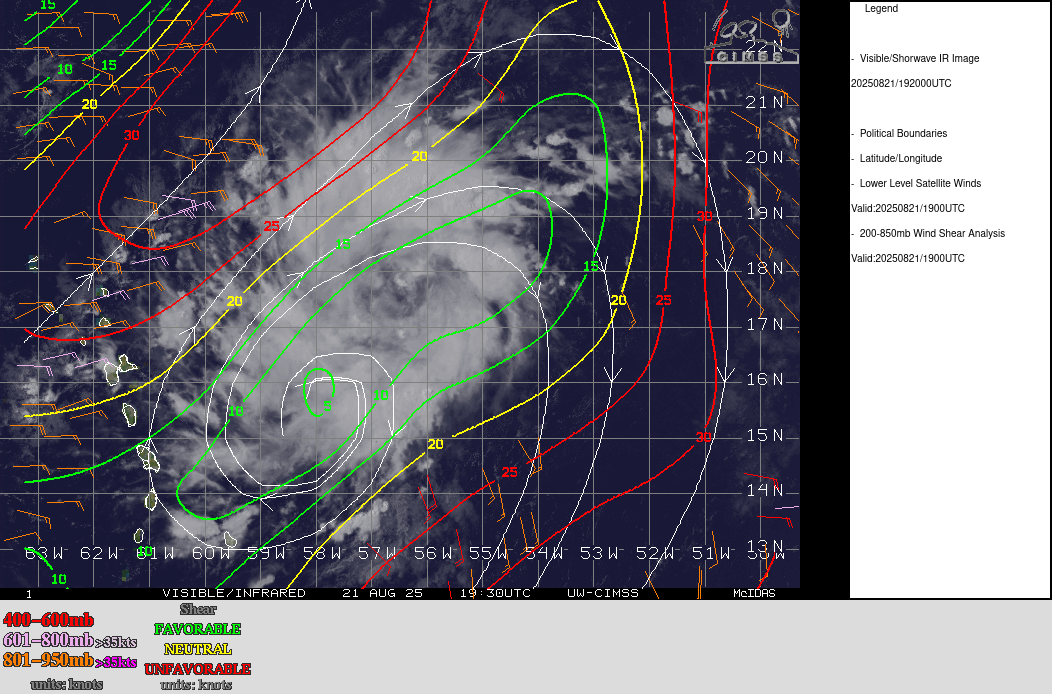
Above: Invest 90L 8-21-25-1930z
The northern lobe is at last the one to watch for the greatest near-term potential, now 90L.
This developing system is in a favorable environment of very supportive SSTs, light shear, good upper-level divergence, increasing lower-level convergence and vorticity in the lower levels.
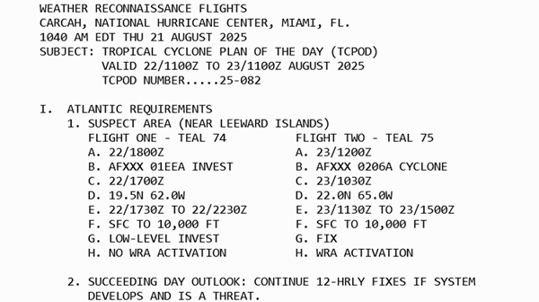
TC-centric model runs have begun and will be better served by the following recon missions already scheduled to check it out.
This system appears to have a pretty decent shot at becoming our next hurricane, possibly even Major, if all its stars remain aligned.
|


 Threaded


