cieldumort
Moderator

Reged:
Posts: 2738
Loc: Austin, Tx
|
|
A stout tropical wave that rolled off of Africa yesterday and has rapidly blown up convection already appears to have developed at least a partially-closed low-level circulation, is now Invest-tagged, 99L.
Invest 99L is located in the extreme eastern Atlantic, and while conditions there may not be as favorable as a fledgling cyclone could like, they are supportive enough for some continued slow development. With the broad, almost gyre-like monsoon low ahead of it we have been tracking helping clear the path, 99L could have an easier go of it for a potential long-track across the Atlantic, and we are starting a Lounge on this feature at this time.
NHC has raised its chances from 10% at the 8PM last night to 30% at 2AM today, and these could be conservative.
|
cieldumort
Moderator
Reged:
Posts: 2738
Loc: Austin, Tx
|
|
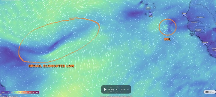
Above: lower level winds as analyzed by ICON13K of 99L (R) near the Cabo Verde Islands and the broad, monsoonal trof ahead of it (L)
Base image cr: Zoom Earth
|
cieldumort
Moderator
Reged:
Posts: 2738
Loc: Austin, Tx
|
|
Triggers have been pulled for more marginal systems.
Only a very slight increase in organization would all but force Advisories to begin on 99L as TC genesis has been underway for several hours now.
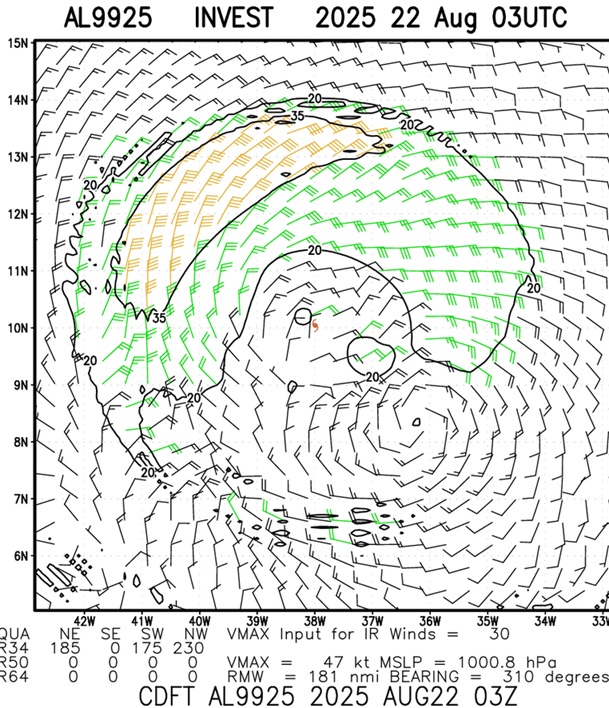
CDFT Scat Analysis 8-22-25-03z
|
cieldumort
Moderator
Reged:
Posts: 2738
Loc: Austin, Tx
|
|
Above: Invest 99L Pseudo-VIS Gif credit: Dapiya.top
The incipient tropical cyclone is still cocooned off from dry Saharan Air around it and also traveling within a fairly steady-state pocket of light to at most low-moderate shear. With scatterometer winds supporting at least 35 knots and agencies concurring, naming or not to name at this point is almost irrelevant.
With the above consideration, early hurricane/vort-centric models do not appear to have a decent handle on the present structure of the system and may not do well to predict it just yet. Provided it does not succumb to hostile regions that surround, recon could be tasked for this over the weekend. This would help, as recon is indisputably the best source of accurate data for models to ingest in systems too far from land.
|
cieldumort
Moderator
Reged:
Posts: 2738
Loc: Austin, Tx
|
|
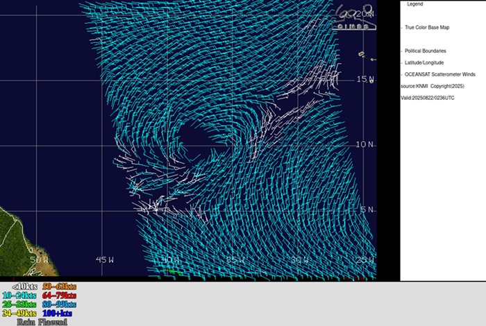
Above: Oceansat Scatterometer wind analysis of 99L on 8/22/25/0236z shows a well-defined circulation
Higher resolution versions of the above show several 35 knot vectors, but are not shown here. This is just the broad overview clearly portraying a well-defined surface circulation.
|
cieldumort
Moderator
Reged:
Posts: 2738
Loc: Austin, Tx
|
|
Three initial recon missions set for Sunday thru Monday

|
MikeC
Admin
Reged:
Posts: 4835
Loc: Orlando, FL
|
|
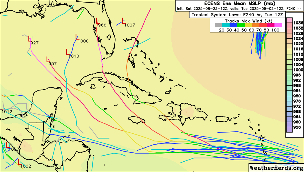
Not a lot of model support, but models have been underestimating this so far. Euro ensembles make it worth watching if it does "overperform" though. If it got close to Florida it would be around labor day. I don't think it will happen, but it's worth keeping an eye on.
|
MikeC
Admin
Reged:
Posts: 4835
Loc: Orlando, FL
|
|
99L looks marginal tonight. Right now I'd lean toward the euro ensembles/icon as outliers (I.e. the stronger ones aren't going to happen), thus 99l will likely struggle. Recon tomorrow should help. Something to keep an eye on, but not too concerning yet. Those in the islands will want to see what recon finds, however. Right now 99L is a somewhat elongated wave without a strong circulation. I.e. it didn't really do much tonight.
|
cieldumort
Moderator
Reged:
Posts: 2738
Loc: Austin, Tx
|
|
Shear is rather prohibitive tonight, but could ease up as 99L draws closer to or passes through the Windwards.
Operational 0z run now develops 99L over/near NW Caribbean/Yucatan roughly a week out, joining the early-to-print 0z ICON.
|
cieldumort
Moderator
Reged:
Posts: 2738
Loc: Austin, Tx
|
|
Today's 0z Operational starting at hour 150 (August 30th/06z) and ending at hour 300 (Friday 12Z Sep 5th)
|
MikeC
Admin
Reged:
Posts: 4835
Loc: Orlando, FL
|
|
:6z does not develop 99L. No euro ensembles get into the Gulf, the Icon is weaker, and a the few ensembles that get into the gulf stall it out somewhere in the Gulf. Just not a lot of support for 99L. Conditions are pretty hostile for it at the moment, recon goes out there tonight, so hopefully it'll help with 99L. It's tenacious, but there is still no low level circulation to speak of. But right now I'd say this isn't going to do much more than rain a lot in the Yucatan Peninsula when it gets over there. Setup just isn't right for much more than that. Still late August so it's something to watch, but odds are enough to say there's nothing overly concerning at the moment. That doesn't mean quit watching it, just that the odds are stacked against it right now.
It's moving too fast this morning to really get the LLC going, so I don't expect much. Something to watch down the road, but this pattern typically puts the waves into Central America, hurricane Michael was a notable exception to that idea, another was Dolly in 2008, so there is precedent, but it's still very unlikely. Barbados and the islands will get gusy wind and rain today/tomorrow though.
Since 99L is starting to enter radar range I added two radar records of it https://flhurricane.com/cyclone/animationlist.php
|
MikeC
Admin
Reged:
Posts: 4835
Loc: Orlando, FL
|
|
12z Icon, , and don't show 99L developing, and all gettin energy into Honduras, /GFS do hint something may occur in the eastern pacific with it (matching several ensembles). The is showing a front spinup in the Gulf that's not part of 99L, though.
Recon is heading there now.
|
MikeC
Admin
Reged:
Posts: 4835
Loc: Orlando, FL
|
|
Recon so far is finding 99L to be an open wave, so no development likely before the islands. Afterwards conditions aren't good for development either.
|
MikeC
Admin
Reged:
Posts: 4835
Loc: Orlando, FL
|
|
TWO special update, chances reduced to 30% for 99L.
Data from the Air Force reconnaissance aircraft indicate that the
system located near the Windward Islands does not have a closed
low-level circulation. However, the system is still producing a
large area of showers and thunderstorms and winds to near gale
force, and these conditions are expected to affect the Windward and
Leeward Islands tonight and Monday. The system is expected to reach
the central Caribbean Sea on Tuesday, where conditions are forecast
to become less favorable for additional development.
|
MikeC
Admin
Reged:
Posts: 4835
Loc: Orlando, FL
|
|
The Tropical Weather Outlook has 99L down to 0%, it no longer shows up on ensembles or any operational models in the Atlantic.
|
cieldumort
Moderator
Reged:
Posts: 2738
Loc: Austin, Tx
|
|
Continuing to keep tabs on what is now (x)99L.
The disturbance formerly tracked as Invest 99L began re-firing convection overnight Monday, taking advantage of both the improved nighttime instability over the warm ocean, as well as moderately divergent winds aloft. This has given what was the shell of a vort left in the wake of devastatingly strong shear some footing.
As this wave has consistently been underbid by models all across the Atlantic, there is impetus for discounting their handle and forecast of the feature, and while is down at 0%, I have been and remain convinced that upon reaching the northwestern Caribbean this could be going right back up along with a "greenballing" of the 99L tag. I'd put the odds of the Invest tag getting resurrected at about 40% within 5 days, and should the disturbance indeed be developed enough once again for an Invest tag, a look at conditions that lay ahead suggest that there would also be about a 33% chance of TC genesis somewhere around the Yucatan, in the Gulf, or in the far eastern Pacific (which if Pacific, it's no longer a threat around here).
These are just some thoughts and are not supported by models, but as mentioned, neither was 99L's ability to keep on going and going and going all across the Atlantic. By most models' runs, it was never to make it to the Caribbean in the first place.
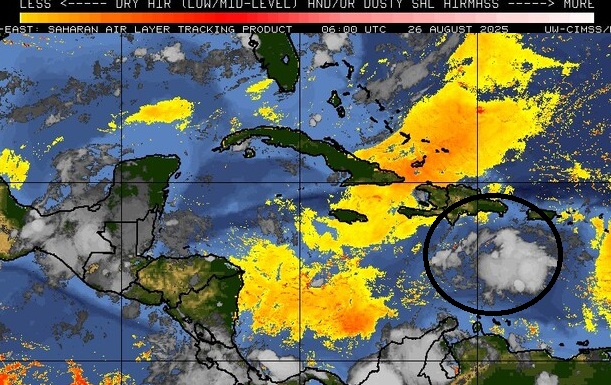
Above: x99L (circled in black) remains cocooned off from nearby dry air ("SAL") that is furthermore easing up in the W ATL
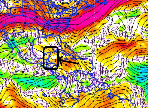
Above: 200-800mb zonal shear forecast from 26/0z valid for 8/29/0z with a rectangle black box over an approximate range of where x99 could be located then. White would be neutral for development and this would make the NW Carib the "sweet spot."
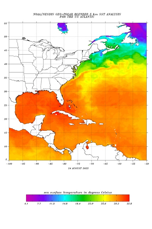
Above: SSTs in the NW Carib and Gulf are exceptionally warm, far warmer than anything 99L had to attempt to avail itself heading across the Tropical Atlantic.
|
cieldumort
Moderator
Reged:
Posts: 2738
Loc: Austin, Tx
|
|
Above: x99L 0515-0825z today 8/26
|
MikeC
Admin
Reged:
Posts: 4835
Loc: Orlando, FL
|
|
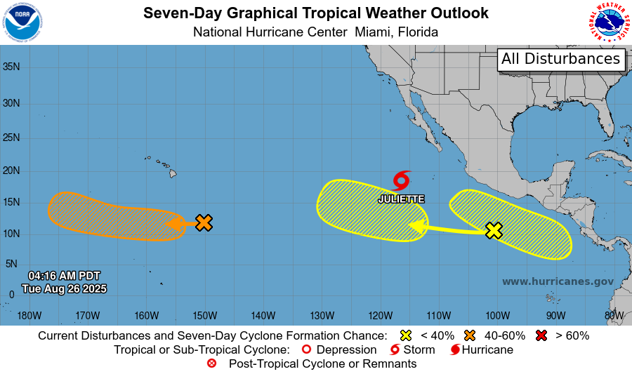
Land friction as the former 99L moves over central America moves it into the east pacific where it could get going there again, (The right yellow area on the east pacific outlook is from the remnants of 99l)
|


 Threaded


