cieldumort
Moderator

Reged:
Posts: 2910
Loc: Austin, Tx
|
|
A roughly eight day window for development in the Gulf is starting to get a lot more hits from extended range quality models and their ensembles. It is not immediately clear if this will be from a Central American Gyre, wave, or combination of both, but the general region of projected best genesis potential seems to favor either or both. The signal has been consistent, with the stellar Google DeepMind FNv3 now implying 40% odds of development from the western Caribbean into the Gulf during this window. Given the very consistent signal, we are starting a Lounge on this projected system, Invest TBD, at this time.
It is worth noting that 2026 has not seen a hurricane form yet in the Atlantic basin and the current El Niño has been much stronger than forecasts prior to the start of the season. In fact, this El Niño is setting all-time records going back at least decades and likely centuries. Given that we do not have much historical precedent to work off of as far as how this could influence modeling this far out, some consideration should be given that they could be overcooking things. Nonetheless, here are some examples:
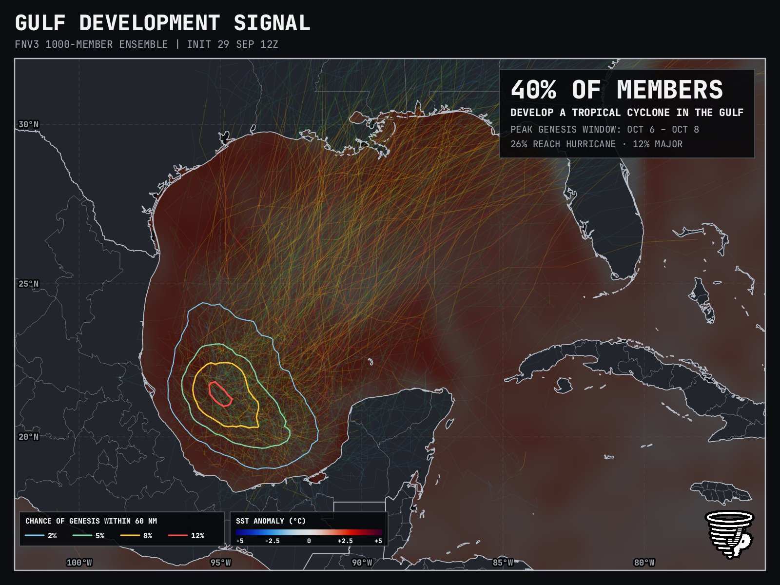
Image credit: James Pettus @PettusWX pettusplots.com
The most recent DeepMind generation, WNv3, is not as impressed, at 22% development odds. Timeline is about the same, with median genesis 228 hours from 12Z today (0z Oct 9)
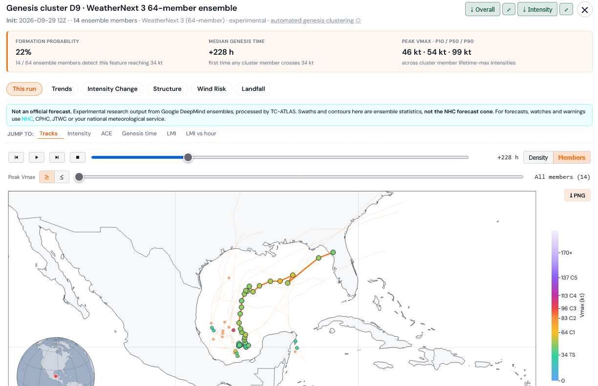
Credit: TC-ATLAS
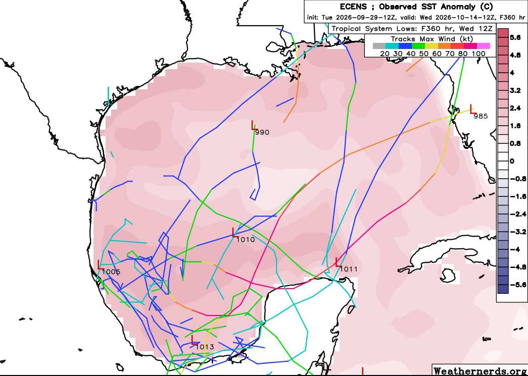
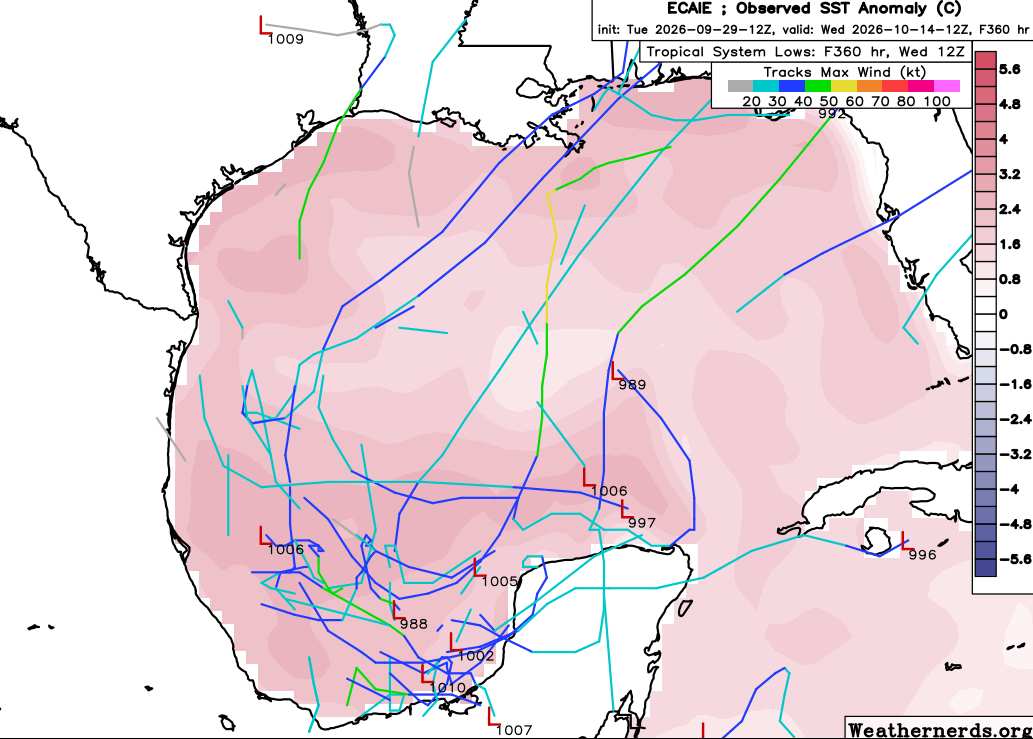
This feature has just been Invest tagged, 92L, and the title has been updated accordingly 10/5/26 1PM CDT
Ciel
Edited by cieldumort (Mon Oct 05 2026 02:34 PM)
|
cieldumort
Moderator
Reged:
Posts: 2910
Loc: Austin, Tx
|
|
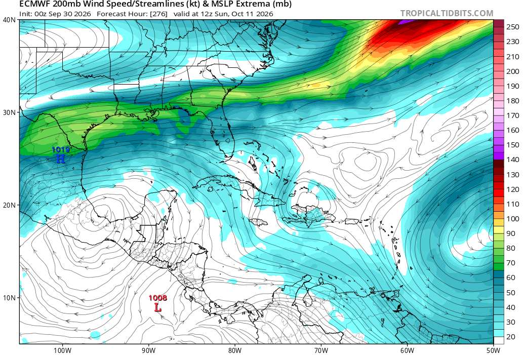
In general, this window favors development from all the usual suspects in and around the Gulf. However, anything that might want to form from a front in the northern Gulf could just trend more subtropical or at the very least sheared/struggling, while anything that might want to form in the Bay of Campeche (Central American Gyre-born/EPac crossover/tropical wave) looks to have much better odds of being purely tropical with potentially a higher intensity ceiling. Upper level winds/lift forecast to become quite favorable over the BOC during the middle of this window, as can be seen below.
|
cieldumort
Moderator
Reged:
Posts: 2910
Loc: Austin, Tx
|
|
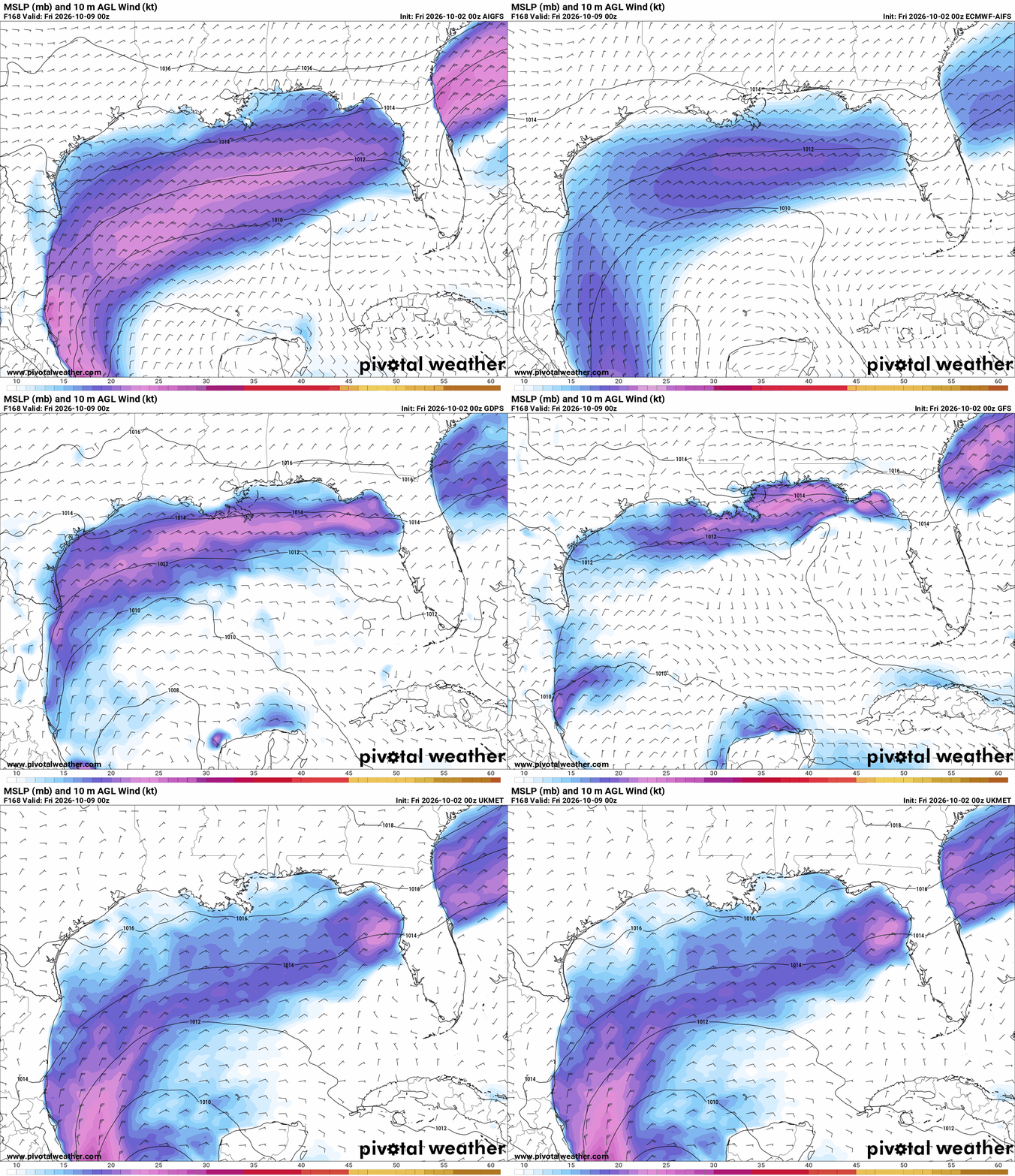
Out to 168 from 0z today, most Globals now advertise at least weak cyclonic surface flow in the Gulf, predominately around the Bay of Campeche-Yucatan Peninsula, save the ICON.
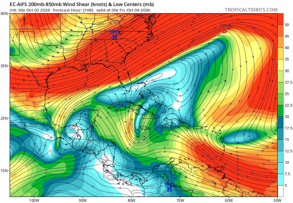
However, shear at this time could be prohibitive
|
cieldumort
Moderator
Reged:
Posts: 2910
Loc: Austin, Tx
|
|
Globals that are at least lukewarm to the idea of some kind of development in the Gulf during this window continue favoring a CAG and/or crossover method. While there are a few runs that tease something in the northern Gulf or even the east coast of Florida, those appear to be non-tropical lows, or subtropical at best, getting mistaken for tropical.
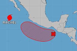
Taking a look at today's runs that do show development potential in the western Gulf, most only support a weaker and quicker storm, which makes sense with forecasts of ongoing high levels of shear. One caveat to the shear forecast, is that a good deal of the shear models see during this otherwise so-so window is a result of and possibly contingent on the development of yet another far east Pac tropical cyclone (as seen below shown to be an 80% region to the southeast of Hurricane Rachel in the )
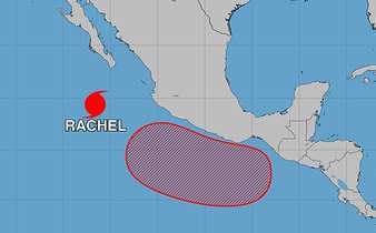
Should the Area of Interest presently southeast of Rachel not track close to mainland Mexico as forecast, shear across the Gulf could be less. Another wild card would be for this AOI to cross over into the BOC. A few models and/or ensembles suggest either as possible.
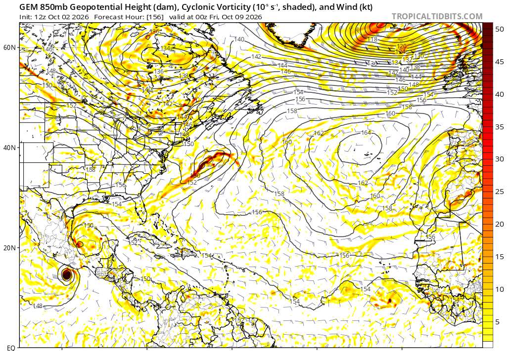
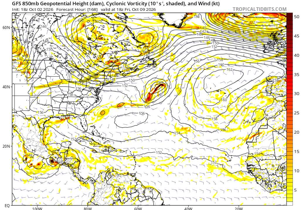
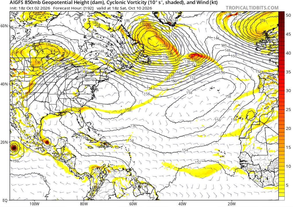
Some quick glances at a few of today's Globals
CANADIAN out to 156 hours advertising development on both sides of Central America (the previously noted AOI in the east Pac as well as a new disturbance in the BoC)
GFS takes the east Pac AOI itself across the Isthmus of Tehuantepec and creates a trof in the western Gulf, but without much development there. Rain-maker for east TX.
The AI makes like the Canadian and spawns two systems on either side of Central America, but the Gulf feature is kept weak, short-lived and runs into Mexico.
The window is still open, but this is a window with a lot of doubts, and if anything does form, unlike a lot of the hype seen in social media, odds are really that it would be weak and/or short-lived, with only an outlier chance of a strong cyclone (maybe at best 10-15% of something below 995mb IMHO)
|
cieldumort
Moderator
Reged:
Posts: 2910
Loc: Austin, Tx
|
|
This is an incredibly tricky season for both models and forecasters alike where the Atlantic basin is concerned. The one safe bet all season would have been, has been, should have been, "Nothing becomes a hurricane." Fay and possibly Edouard got close, but no cigar*. With this backdrop, the rational thing to do is ignore any model runs that ramp up this yet-to-form system in the Gulf beyond 60 MPH unless and until something is getting obvious.
The most recent suite of 0z Globals during this window.
Quick Globals rundown:
EURO - Sloppy Trof; borderline TD at times by 10/11/06z in northern Gulf
EURO AI - Weak Tropical Low by 10/11/0z in northwestern Gulf
GFS - TD or Low-end Trop Storm by 10/12/06z in northwestern Gulf
GFS AI - TD by 10/11/0z in the southwestern Gulf. Quickly makes landfall in western BOC mainland MX.
ICON - Borderline TD by 10/10/06z in the northern Gulf.
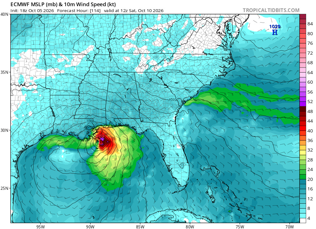
UKMET - Apparent TD or weak Trop Storm in the southwestern Gulf by 10/07/21z. Making landfall around Cape San Blas, Gulf County, 10/10/0z 989mb.
As for the Google DeepMind FNv3 ensembles, after a dip with their 18Z run, the most recent 0z came back in implying a 30% chance of this becoming a Tropical Storm
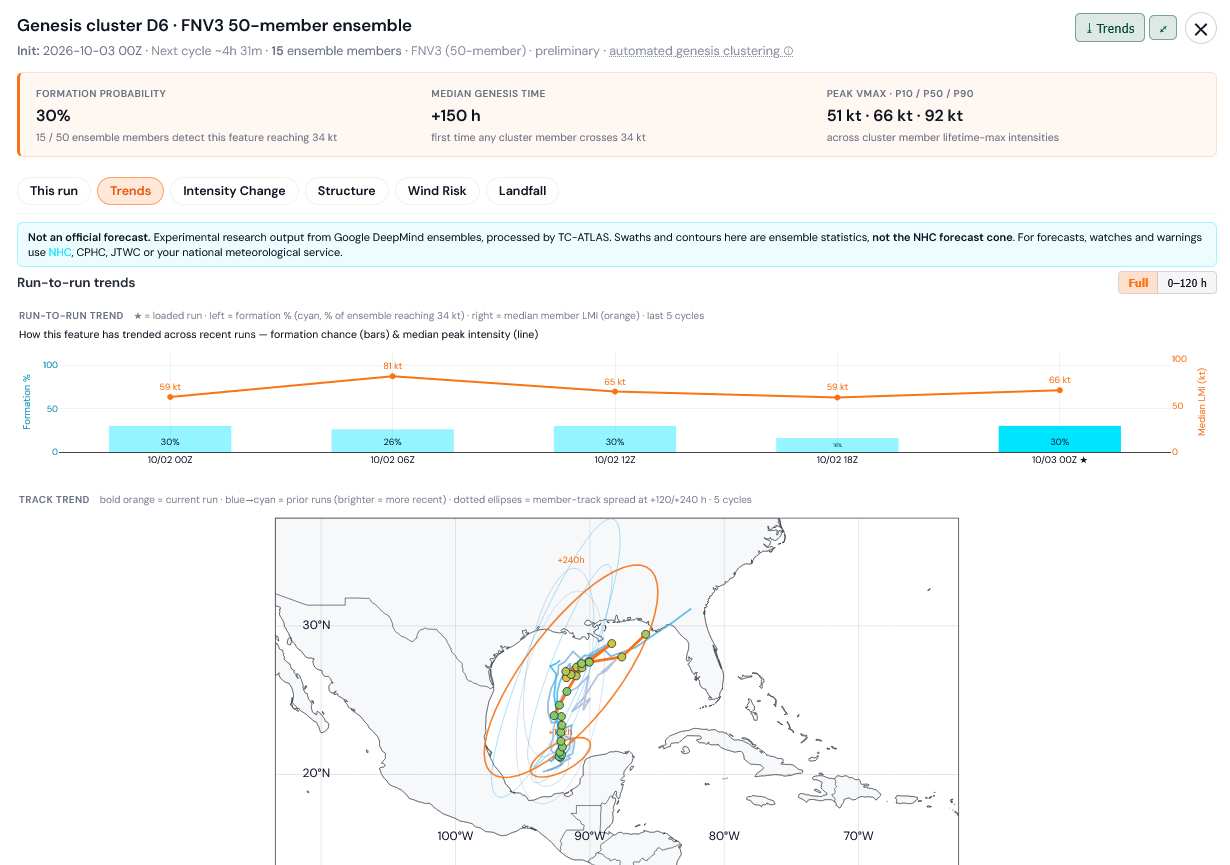
Credits: TC-ATLAS and Google
*Both Fay and Edouard were likely stronger than operational advisories had them and one or both could easily be upgraded during reanalysis. Only referring to real-time Advisories.
|
cieldumort
Moderator
Reged:
Posts: 2910
Loc: Austin, Tx
|
|
Here are the results of some 12Z Globals out today. Showing just TC genesis as "YES" or "NO" going out to 240 hours (10 days from today) and the date of apparent TC formation
EURO: NO
EURO AI: NO
GFS: YES Oct 8
GFS AI: YES Oct 10
CANADIAN: YES Oct 10
ICON: YES Oct 8
UKMET: YES Oct 8
|
cieldumort
Moderator
Reged:
Posts: 2910
Loc: Austin, Tx
|
|
Models, including the high quality DeepMind versions and their ensembles, continue gradually, if unevenly, warming up to development potential in the Gulf within this window. In addition, an increasing number of ensemble members ramp things up a bit intensity-wise. While this season has mostly produced weak storms so far, the Gulf this time of year can see upside surprises that are also immediately landlocked and likely to make landfall somewhere.
Big jump in the DeepMind FNv3 50 suite compared to yesterday, now implying 42% odds of at least a tropical storm, with a median genesis of early morning Oct 8th
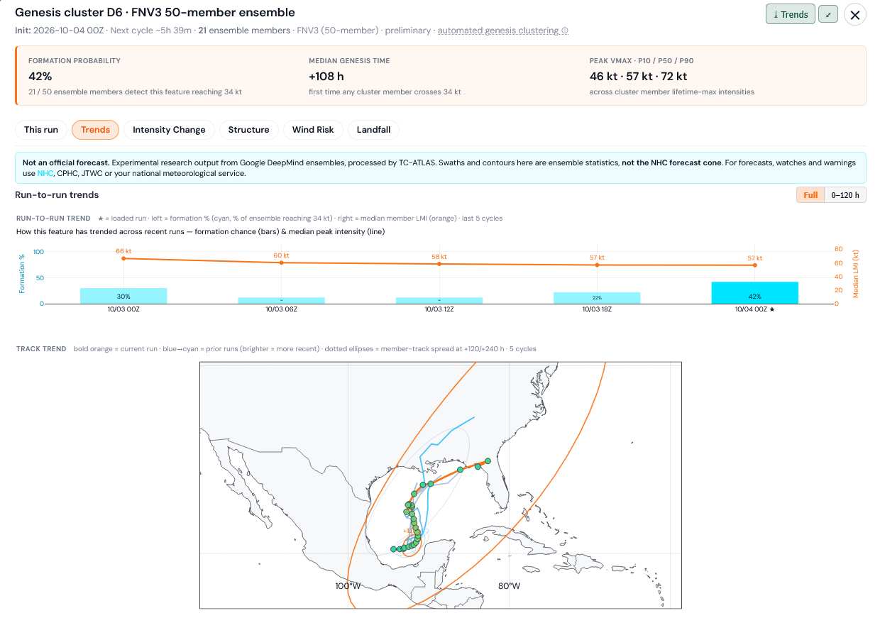
Credit: TC-ATLAS
|
MikeC
Admin
Reged:
Posts: 4867
Loc: Orlando, FL
|
|
This is a 30% area now, which seems reasonable. Most likely outcome is just a very wet messy area though, shear will likely keep it from developing, however if it lines up correctly it could change. Need to watch it either way.
|
cieldumort
Moderator
Reged:
Posts: 2910
Loc: Austin, Tx
|
|
Marginally CAG-favorable state as of today and forecast to become more supportive during this window
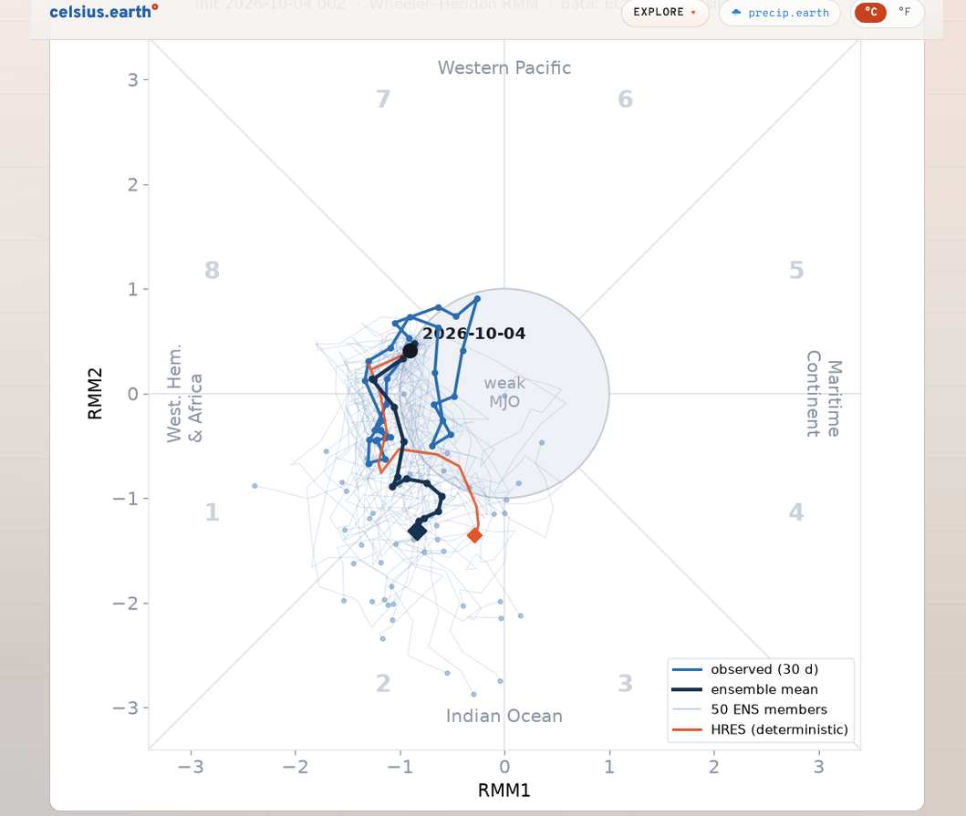
Image credit: Celsius.earth
|
cieldumort
Moderator
Reged:
Posts: 2910
Loc: Austin, Tx
|
|
ASCAT displaying surface spin already evident today in two locations either side of the Isthmus of Tehuantepec
- Far western Gulf well south of Brownsville, TX and
- Just south of Guatemala
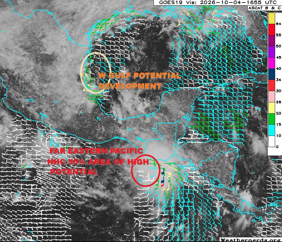
Base satellite/ascat map credit: Weathernerds.org
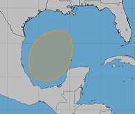
Credits:
|
cieldumort
Moderator
Reged:
Posts: 2910
Loc: Austin, Tx
|
|
Model support for development of this potential future system is effectively now approaching 100% overall, and there are also some very plausible runs making this a hurricane. Without an Invest*, it is far too early to speculate as to actual intensity and track. Lots of known unknowns that can influence its intensity that won't become clear unless and until a bona fide disturbance has taken shape. Track-wise, there are also a number of known unknowns which can shuffle things around for a while. It is even possible that the future system, assuming it develops, meanders in the western to central Gulf before taking a more decisive track inland.
For now, any one model or ensemble run remains completely uncertain and speculative, but the table is definitely set for development and potentially for substantial development.
10/05/0z Globals YES/NO and apparent earliest development date if YES:
EURO: YES Oct 8th
EURO AI: YES Oct 7th
GFS: YES Oct 7th
GFS AI: YES Oct 8th
CANADIAN: YES Oct 10th
ICON: YES Oct 6th
UKMET: YES Oct 7th
10/04/18z DeepMind Ensembles
FNv3: 77% of 1,000 members develop into a Tropical Storm (implication being even higher of at least a Tropical Depression)
WN3: 88% of 64 members develop into a Tropical Storm (same TD or better implication as above)
*Invest tag could be coming as soon as later today, in which case, hurricane models would start running and recon would most likely be flown. There is a tentative mission now already on the books for Wednesday, which would likely get moved up with the introduction of an Invest number.
|
MikeC
Admin
Reged:
Posts: 4867
Loc: Orlando, FL
|
|
Most likely it'll be a rainy weekend along the northern Gulf, hybrid or potential tropical storm. Hurricane is extremely unlikely but not impossible. I wouldn't expect much from this though. The overall Atlantic effect this year is still suppressed by El Nino, so weak once again is by far the most likely scenario. General message is, keep watch, but unlikely to be much.
|
cieldumort
Moderator
Reged:
Posts: 2910
Loc: Austin, Tx
|
|
|
cieldumort
Moderator
Reged:
Posts: 2910
Loc: Austin, Tx
|
|
As noted by Dr. Levi Cowen (TropicalTidbits) above, the models are basically split into two camps, with several of the classic models less bullish vs. the AIs favoring the positioning of the disturbance (then TC) in the most favorable region possible. Essentially a few stars aligned vs. almost all, if not all, stars aligned.
The implications of which scenario is most correct are stark. With the less ideal solutions, our disturbance struggles with shear and dry air, possibly never even becoming a Tropical Storm at all. On the other side, what looks to myself and others to be about an equally valid possibility, the then-Tropical Cyclone finds itself benefiting mightily from strong upper-level divergence and much lower shear while tracking over very, very warm waters.
The intensity ceiling scenario of situation #1, the weaker scenario, is probably limited to a strong tropical storm at best, unless the system stays locked in the Gulf long enough for conditions for further development to improve, which is possible.
The intensity ceiling of situation #2, the forecast increasingly preferred by AI models, is very high, with plausible Major Hurricane outcomes, albeit as of now, low odds. But as models would have it, right now they imply about a 50-50 shot of this becoming a hurricane.
|
cieldumort
Moderator
Reged:
Posts: 2910
Loc: Austin, Tx
|
|
Results of today's 06Z FNv3 1000 member ensembles are in and they are continuing the trend of greater confidence + higher potential intensities
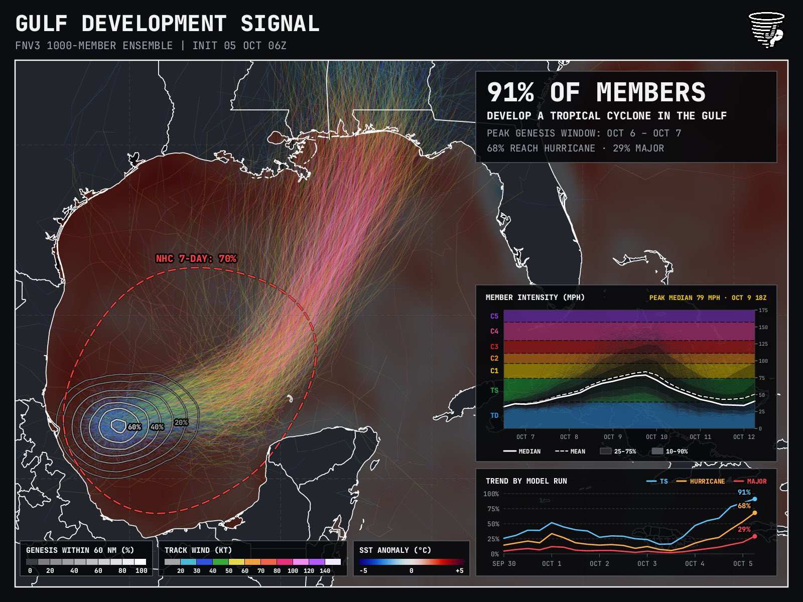
Image credit: James Pettus @PettusWX pettusplots.com
|
CFHC

Reged:
Posts: 217
Loc: East Central Florida
|
|
Throwback model link https://flhurricane.com/throwbackspaghet...9&zoom=5.12
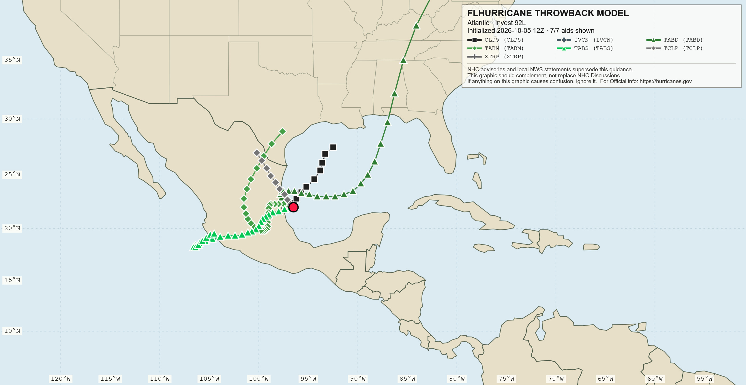
Still think it's a messy tropical storm at best, east side is where most of the weather will be. East Pacific's 92E (if it gets going quickly) likely would starve off anything in the Atlantic also. Overall concern level is low.
|
cieldumort
Moderator
Reged:
Posts: 2910
Loc: Austin, Tx
|
|
|
MikeC
Admin
Reged:
Posts: 4867
Loc: Orlando, FL
|
|
The 18Z euro has flipped too. We'll see if it gets going early tomorrow night or not (Recon will be out there late) Still don't think this winds up a hurricane at landfall with the shear, we'll see.
 1 1
|
cieldumort
Moderator
Reged:
Posts: 2910
Loc: Austin, Tx
|
|
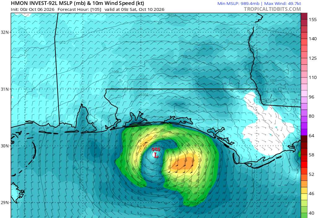
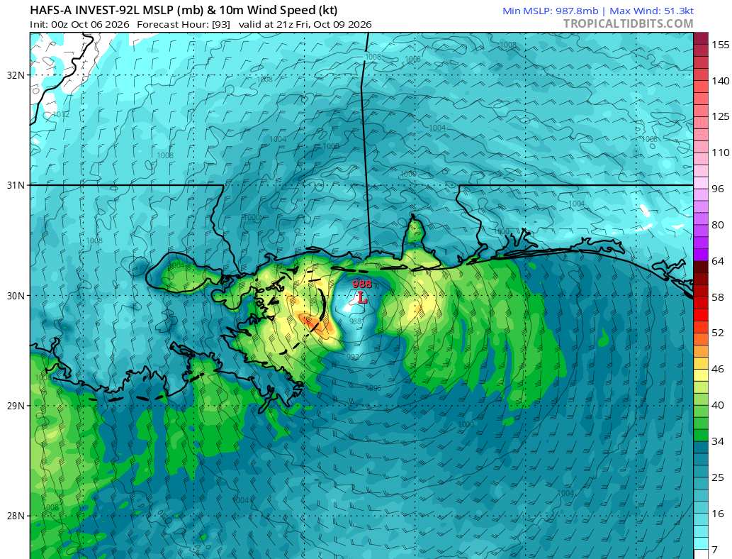
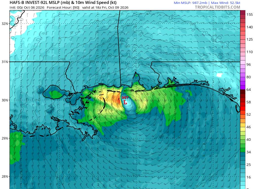
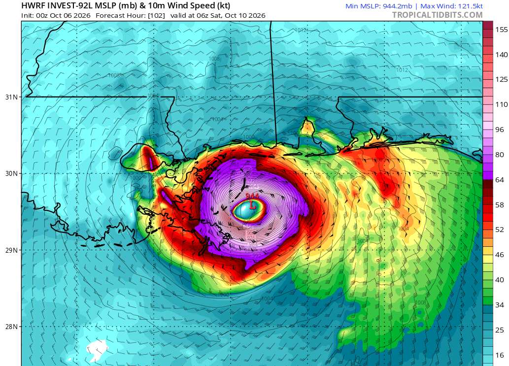
We really need those recon missions into 92L
Several 0z hurricane models blow the Invest up while in the Gulf, but then dry air and shear takes their toll on the cyclone by the time it is nearing the coast, and unlike Edouard which was intensifying into landfall, 92L - then Isaias - weakens dramatically into landfall. Side rant ~ If this were to actually happen, we could in theory have a Major in the Gulf, watches and warnings put up along the northern Gulf coast and official forecasts from calling for weakening by landfall, but with people frantically checking the latest clickbait worst-case runs on social media and freaking out. Then blame the of course should Isaias roll onshore more like a wet lamb after social media posts roared like a fierce lion.
Other models, including the operationally retired HWRF, maintain a vigorous Major all the way into landfall.
Recon ASAP is going to be critical in nailing this forecast with enough time.
Here are some heading-into-landfall forecasts from the hurricane models
Screenshots credits: TropicalTidbits
Reassuring that the HWRF is now often thought of as more of a C-tier model, replaced and bested by the HAFS. Still, a model run that deserves consideration until proven otherwise.
|
IsoFlame
Weather Analyst

Reged:
Posts: 416
Loc: One block off the Atlantic Oce...
|
|
Quote:
We really need those recon missions into 92L. Several 0z hurricane models blow the Invest up while in the Gulf, but then dry air and shear takes their toll on the cyclone by the time it is nearing the coast, and unlike Edouard which was into landfall, 92L - then Isaias weakens dramatically into landfall. Side rant ~ If this were to actually happen, we could in theory have a Major in the Gulf, watches and warnings put up along the northern Gulf coast and official forecasts from calling for weakening by landfall, but with people frantically checking the latest clickbait worst-case runs on social media and freaking out. Then blame the of course should Isaias roll onshore more like a wet lamb after social media posts roared like a fierce lion. Other models, including the operationally retired HWRF, maintain a vigorous Major all the way into landfall. Often thought of as more of a C-tier model, replaced and bested by the HAFS. Still, a model run that deserves consideration until proven otherwise.
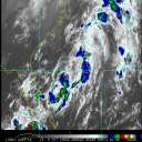
Impressive/explosive deep convection underway this morning: GOES-19 - Sector view: Gulf of America - GeoColor - NOAA / NESDIS / STAR
--------------------
CoCoRaHS Weather Observer (FL-VL-42) & Surf Forecaster: https://www.surf-station.com/north-florida-surf-forecast-3/
|



 Previous
 Index
Index
 Next
Next
 Threaded


 Edit
Edit
 Reply
Reply
 Quote
Quote


