Central Florida Hurricane Center
2000 News and Story Archives:
See This link for archives newer than 2002
Archived Year: [1996] [1997] [1998] [1999] [2000] [2001] [2002]
 Suggestions
Merry Christmas and Happy New Year
08:37 PM EST - 22 December 2000
| No Comments
This is planned to be the last article for "Central Florida Hurricane Center 2000". Next year will bring 21st Century CFHC, and the delayed summary of this past year as well as a summary for the next year.
The last couple of days have been interesting too. A system in the Caribbean was churning that would have a good chance to be tropical during the season, but since the season is out, the chances are slim to none.
I've returned from my stint in the Hampton Roads area in Virginia and am now back in Florida, so next year should be better. A programming project I am working on for another website will have direct benefits for us here as well, with a very interesting update of the old warning system as well as plans for a mini client similar to weatherbug that focuses on Hurricanes and Tropical Systems for Windows systems. (For those worried about yet another bloated tray icon program, I am well aware of it and I am using an approach which will reduce memory requirements and dependencies to the bare bones. Technically, modular WINAPI C only -- similar to this site being very plain... but quick. I prefer quick over looks when you are searching for real information.)
Along with other general improvements in the info gathering area, I am open to suggestions for other things. We will have at least two new webcams for the next year as well. One confirmed for downtown Orlando, and another one possible for New Smyrna Beach.
We'll continue to write and allow your opinions to count as well, as information on storms during events is good. And it becomes invaluable to seperate real information from misinformation as well as offer a way to correct and add to each other. And post disaster, it becomes a good way to request and offer reports on the various affected areas.
So once again, I thank everyone from all over that has used the site over the past year, and hope to see you back next year.
Happy Holidays!
- [mac]
Last Day of 2000 Hurricane Season
09:10 AM EST - 30 November 2000
| Thirteen Comments | Read Comments | Newest: 05:51 PM 12-22 EDT
November 30th, the last day of the 2000 Hurricane Season is here. And, strangely enough, there is an area in the Western Caribbean that bears watching. Although it is unlikely anything will form, it does look pretty good for this time of year and will have to be watched for development.
This year has been a very active year, but with a lot of close calls and nothing extremely destructive. Debby being the most potentially threatening of them all for the US. A better run down of systems will come in the next few days.
Thanks for all the support this year. We intend to be back next year with even more information. The site will run throughout the year with minor and sporadic updates in the off season.
Comments or Questions? Everyone is invited to use it. Use the comment button by the story Headline.
NRL Monterey Marine Meteorology Division Forecast Track of Active Systems (Good Forecast Track Graphic and Satellite Photos)
Crown Weather Services Tropical Update (Includes Map with multiple forecast model tracks)
Snonut's Hurricane Reports
Other commentary at: Mike Anderson's East Coast Tropical Weather Center - Stormwarn2000 - SCOTTSVB's Hurricane Update Center - Jim Williams' Hurricane City - Gary Gray's Millennium Weather - Even More on our Links Page
- Satellite images at:
[Visible] (visible -- Daytime Only) [Infrared] (infrared), and [Water Vapor] (water vapor)
- Loops: Visible
Loop - Infrared
Loop - Water
Vapor Loop
NASA GHCC Interactive Satellite images at:
[NAtl visible] (visible -- Daytime Only) [NAtl infrared] (infrared), and [NAtl water vapor] (water vapor)--Nasa source.
Defiant Visible Infrared More...
Ocean Surface Winds Derived from the SeaWinds Scatterometer (Experimental)
Tormenta.net Espa�ol -- Gran informaci�n sobre huracanes aqu�.
Some Forecast models:
(NGM, AVN, MRF, ECMWF, ETA)
DoD weather models (NOGAPS, AVN, MRF)
AVN, ECMWF, GFDL, NOGAPS, UKMET
- [mac]
November
09:26 AM EST - 05 November 2000
| Five Comments | Read Comments | Newest: 10:11 AM 11-28 EDT
The month of November will most likely remain quiet. Hurricane Season is winding down and will be over on November 30th. This year had quite a number of storms, but none that were very destructive.
We'll continue to watch until the end. Thanks for all the participation in the message boards. We hope to improve upon the site for next year, without compromising what works now.
Comments or Questions? Everyone is invited to use it. Use the comment button by the story Headline.
NRL Monterey Marine Meteorology Division Forecast Track of Active Systems (Good Forecast Track Graphic and Satellite Photos)
Crown Weather Services Tropical Update (Includes Map with multiple forecast model tracks)
Snonut's Hurricane Reports
Other commentary at: Mike Anderson's East Coast Tropical Weather Center - Stormwarn2000 - SCOTTSVB's Hurricane Update Center - Jim Williams' Hurricane City - Gary Gray's Millennium Weather - Even More on our Links Page
- Satellite images at:
[Visible] (visible -- Daytime Only) [Infrared] (infrared), and [Water Vapor] (water vapor)
- Loops: Visible
Loop - Infrared
Loop - Water
Vapor Loop
NASA GHCC Interactive Satellite images at:
[NAtl visible] (visible -- Daytime Only) [NAtl infrared] (infrared), and [NAtl water vapor] (water vapor)--Nasa source.
Defiant Visible Infrared More...
Ocean Surface Winds Derived from the SeaWinds Scatterometer (Experimental)
Tormenta.net Espa�ol -- Gran informaci�n sobre huracanes aqu�.
Some Forecast models:
(NGM, AVN, MRF, ECMWF, ETA)
DoD weather models (NOGAPS, AVN, MRF)
AVN, ECMWF, GFDL, NOGAPS, UKMET
- [mac]
Southwest Caribbean
07:51 AM EST - 29 October 2000
| Five Comments | Read Comments | Newest: 01:20 PM 11-03 EDT
Right now the only thing worth watching is in the Southwestern Caribbean Sea. There is a persistant area that may want to form over the next few days. Folks along the coast in that area should be watching in case something does form. If it does, I don't expect anything major.
The low in the Atlantic has moved up and out without forming into anything tropical.
Today was the day you should have set your clocks back an hour. If you forgot, do it now.
Comments or Questions? Everyone is invited to use it. Use the comment button by the story Headline.
NRL Monterey Marine Meteorology Division Forecast Track of Active Systems (Good Forecast Track Graphic and Satellite Photos)
Crown Weather Services Tropical Update (Includes Map with multiple forecast model tracks)
Snonut's Hurricane Reports
Other commentary at: Mike Anderson's East Coast Tropical Weather Center - Stormwarn2000 - SCOTTSVB's Hurricane Update Center - Jim Williams' Hurricane City - Gary Gray's Millennium Weather - Even More on our Links Page
- Satellite images at:
[Visible] (visible -- Daytime Only) [Infrared] (infrared), and [Water Vapor] (water vapor)
- Loops: Visible
Loop - Infrared
Loop - Water
Vapor Loop
NASA GHCC Interactive Satellite images at:
[NAtl visible] (visible -- Daytime Only) [NAtl infrared] (infrared), and [NAtl water vapor] (water vapor)--Nasa source.
Defiant Visible Infrared More...
Ocean Surface Winds Derived from the SeaWinds Scatterometer (Experimental)
Tormenta.net Espa�ol -- Gran informaci�n sobre huracanes aqu�.
Some Forecast models:
(NGM, AVN, MRF, ECMWF, ETA)
DoD weather models (NOGAPS, AVN, MRF)
AVN, ECMWF, GFDL, NOGAPS, UKMET
- [mac]
Low Area Heading Toward US
02:00 PM EDT - 26 October 2000
| Eight Comments | Read Comments | Newest: 12:39 PM 10-27 EDT
There is a low pressure system moving generally toward the west or westnorthwest north of the Bahamas approaching the US. It will probably head more north and northeastward later on before it gets too close, however. Right now it can be considered a non-tropical low system. Hurricane Hunter aircraft are on the way to check it out, needless to say it could bring nasty weather to the east coast of the US or Canada in the form of tropical or non-tropical storm. In fact, a non-tropical system has a much larger windfield (although normally nowhere near as strong as a hurricane). It could convert itself into a subtropical or tropical system, so we will be closely watching it.
Comments or Questions? Everyone is invited to use it. Use the comment button by the story Headline.
NRL Monterey Marine Meteorology Division Forecast Track of Active Systems (Good Forecast Track Graphic and Satellite Photos)
Map with nearly all model projected tracks plotted for Nadine.
From Michael Bryson.
Crown Weather Services Tropical Update (Includes Map with multiple forecast model tracks)
Snonut's Hurricane Reports
Other commentary at: Mike Anderson's East Coast Tropical Weather Center - Stormwarn2000 - SCOTTSVB's Hurricane Update Center - Jim Williams' Hurricane City - Gary Gray's Millennium Weather - Even More on our Links Page
- Satellite images at:
[Visible] (visible -- Daytime Only) [Infrared] (infrared), and [Water Vapor] (water vapor)
- Loops: Visible
Loop - Infrared
Loop - Water
Vapor Loop
NASA GHCC Interactive Satellite images at:
[NAtl visible] (visible -- Daytime Only) [NAtl infrared] (infrared), and [NAtl water vapor] (water vapor)--Nasa source.
Defiant Visible Infrared More...
Ocean Surface Winds Derived from the SeaWinds Scatterometer (Experimental)
Tormenta.net Espa�ol -- Gran informaci�n sobre huracanes aqu�.
Some Forecast models:
(NGM, AVN, MRF, ECMWF, ETA)
DoD weather models (NOGAPS, AVN, MRF)
AVN, ECMWF, GFDL, NOGAPS, UKMET
- [mac]
Caribbean a No Go
02:22 PM EDT - 23 October 2000
| Thirteen Comments | Read Comments | Newest: 01:45 PM 10-26 EDT
The system talked about in the previous article never formed, and right now there is once again nothing going on in the Atlantic. There is an area moving east in the Central Atlantic that looks interesting, but I doubt anything can happen there. The only hint of anything that may happen comes in the form of the forecasting models, but since that goes into the realm of pure speculation, there is no reason to suspect something will develop.
I expect one more named storm this year before it's all said and done.
Comments or Questions? Everyone is invited to use it. Use the comment button by the story Headline.
NRL Monterey Marine Meteorology Division Forecast Track of Active Systems (Good Forecast Track Graphic and Satellite Photos)
Crown Weather Services Tropical Update (Includes Map with multiple forecast model tracks)
Snonut's Hurricane Reports
Other commentary at: Mike Anderson's East Coast Tropical Weather Center - Stormwarn2000 - SCOTTSVB's Hurricane Update Center - Jim Williams' Hurricane City - Gary Gray's Millennium Weather - Even More on our Links Page
- Satellite images at:
[Visible] (visible -- Daytime Only) [Infrared] (infrared), and [Water Vapor] (water vapor)
- Loops: Visible
Loop - Infrared
Loop - Water
Vapor Loop
NASA GHCC Interactive Satellite images at:
[NAtl visible] (visible -- Daytime Only) [NAtl infrared] (infrared), and [NAtl water vapor] (water vapor)--Nasa source.
Defiant Visible Infrared More...
Ocean Surface Winds Derived from the SeaWinds Scatterometer (Experimental)
Tormenta.net Espa�ol -- Gran informaci�n sobre huracanes aqu�.
Some Forecast models:
(NGM, AVN, MRF, ECMWF, ETA)
DoD weather models (NOGAPS, AVN, MRF)
AVN, ECMWF, GFDL, NOGAPS, UKMET
- [mac]
Tropical Storm Nadine Forms
11:42 AM EDT - 20 October 2000
| Six Comments | Read Comments | Newest: 12:26 PM 10-23 EDT
Tropical Depression 18 has strengthened into Nadine, and is moving nowhere near land right now. It is projected to remain a tropical storm, and not move near land.
There's an interesting area in the Southwestern Caribbean Sea that's definitely worth keeping an eye on over the next few days as well. It's very possible TD#19 will show up there.
Comments or Questions? Everyone is invited to use it. Use the comment button by the story Headline.
NRL Monterey Marine Meteorology Division Forecast Track of Active Systems (Good Forecast Track Graphic and Satellite Photos)
Map with nearly all model projected tracks plotted for Nadine.
From Michael Bryson.
Crown Weather Services Tropical Update (Includes Map with multiple forecast model tracks)
Snonut's Hurricane Reports
Other commentary at: Mike Anderson's East Coast Tropical Weather Center - Stormwarn2000 - SCOTTSVB's Hurricane Update Center - Jim Williams' Hurricane City - Gary Gray's Millennium Weather - Even More on our Links Page
- Satellite images at:
[Visible] (visible -- Daytime Only) [Infrared] (infrared), and [Water Vapor] (water vapor)
- Loops: Visible
Loop - Infrared
Loop - Water
Vapor Loop
NASA GHCC Interactive Satellite images at:
[NAtl visible] (visible -- Daytime Only) [NAtl infrared] (infrared), and [NAtl water vapor] (water vapor)--Nasa source.
Defiant Visible Infrared More...
Ocean Surface Winds Derived from the SeaWinds Scatterometer (Experimental)
Tormenta.net Espa�ol -- Gran informaci�n sobre huracanes aqu�.
Some Forecast models:
(NGM, AVN, MRF, ECMWF, ETA)
DoD weather models (NOGAPS, AVN, MRF)
AVN, ECMWF, GFDL, NOGAPS, UKMET
- [jc]
Tropical Depression 18 Forms in Atlantic
06:25 PM EDT - 19 October 2000
| No Comments
Michael is Moving north near Newfoundland and is still a pretty strong Hurricane. It is in the transition to an extratropical system and since its windfield is expanding, folks in that area of the world will see rough weather.
Tropical Depression 18 has formed now, and is not a threat to land. It is likely to become Nadine, so we'll be watching it.
Comments or Questions? Everyone is invited to use it. Use the comment button by the story Headline.
NRL Monterey Marine Meteorology Division Forecast Track of Active Systems (Good Forecast Track Graphic and Satellite Photos)
Map with nearly all model projected tracks plotted for Michael.
From Michael Bryson.
Crown Weather Services Tropical Update (Includes Map with multiple forecast model tracks)
Snonut's Hurricane Reports
Other commentary at: Mike Anderson's East Coast Tropical Weather Center - Stormwarn2000 - SCOTTSVB's Hurricane Update Center - Jim Williams' Hurricane City - Gary Gray's Millennium Weather - Even More on our Links Page
- Satellite images at:
[Visible] (visible -- Daytime Only) [Infrared] (infrared), and [Water Vapor] (water vapor)
- Loops: Visible
Loop - Infrared
Loop - Water
Vapor Loop
NASA GHCC Interactive Satellite images at:
[NAtl visible] (visible -- Daytime Only) [NAtl infrared] (infrared), and [NAtl water vapor] (water vapor)--Nasa source.
Defiant Visible Infrared More...
Ocean Surface Winds Derived from the SeaWinds Scatterometer (Experimental)
Tormenta.net Espa�ol -- Gran informaci�n sobre huracanes aqu�.
Some Forecast models:
(NGM, AVN, MRF, ECMWF, ETA)
DoD weather models (NOGAPS, AVN, MRF)
AVN, ECMWF, GFDL, NOGAPS, UKMET
- [mac]
Another System
07:15 AM EDT - 19 October 2000
| Fourteen Comments | Read Comments | Newest: 11:12 PM 10-19 EDT
Michael is churning itself toward the north and moving over colder waters. Thankfully, it never threatened Bermuda. Now a new system quite a good distance Northeast of Puerto Rico looks like it may be trying to get its act together. We are getting pretty high into the names now, and if it were to develop it would be called Nadine. This too has nearly no chance of affecting land. We will watch it closely, regardless.
Hurricane season is not OVER yet. Last day of it is November 30th. Please remember this.
Comments or Questions? Everyone is invited to use it. Use the comment button by the story Headline.
NRL Monterey Marine Meteorology Division Forecast Track of Active Systems (Good Forecast Track Graphic and Satellite Photos)
Map with nearly all model projected tracks plotted for Michael.
From Michael Bryson.
Crown Weather Services Tropical Update (Includes Map with multiple forecast model tracks)
Snonut's Hurricane Reports
Other commentary at: Mike Anderson's East Coast Tropical Weather Center - Stormwarn2000 - SCOTTSVB's Hurricane Update Center - Jim Williams' Hurricane City - Gary Gray's Millennium Weather - Even More on our Links Page
- Satellite images at:
[Visible] (visible -- Daytime Only) [Infrared] (infrared), and [Water Vapor] (water vapor)
- Loops: Visible
Loop - Infrared
Loop - Water
Vapor Loop
NASA GHCC Interactive Satellite images at:
[NAtl visible] (visible -- Daytime Only) [NAtl infrared] (infrared), and [NAtl water vapor] (water vapor)--Nasa source.
Defiant Visible Infrared More...
Ocean Surface Winds Derived from the SeaWinds Scatterometer (Experimental)
Tormenta.net Espa�ol -- Gran informaci�n sobre huracanes aqu�.
Some Forecast models:
(NGM, AVN, MRF, ECMWF, ETA)
DoD weather models (NOGAPS, AVN, MRF)
AVN, ECMWF, GFDL, NOGAPS, UKMET
- [mac]
Hurricane Michael
05:16 PM EDT - 17 October 2000
| Six Comments | Read Comments | Newest: 03:49 AM 10-19 EDT
Amazingly, Michael has strengthened into a hurricane, which brings into question its potential affect on the island of Bermuda. Folks there will want to keep close eye on it as it has a chance of coming nearby.
Comments or Questions? Everyone is invited to use it. Use the comment button by the story Headline.
NRL Monterey Marine Meteorology Division Forecast Track of Active Systems (Good Forecast Track Graphic and Satellite Photos)
Map with nearly all model projected tracks plotted for Michael.
From Michael Bryson.
Crown Weather Services Tropical Update (Includes Map with multiple forecast model tracks)
Snonut's Hurricane Reports
Other commentary at: Mike Anderson's East Coast Tropical Weather Center - Stormwarn2000 - SCOTTSVB's Hurricane Update Center - Jim Williams' Hurricane City - Gary Gray's Millennium Weather - Even More on our Links Page
- Satellite images at:
[Visible] (visible -- Daytime Only) [Infrared] (infrared), and [Water Vapor] (water vapor)
- Loops: Visible
Loop - Infrared
Loop - Water
Vapor Loop
NASA GHCC Interactive Satellite images at:
[NAtl visible] (visible -- Daytime Only) [NAtl infrared] (infrared), and [NAtl water vapor] (water vapor)--Nasa source.
Defiant Visible Infrared More...
Ocean Surface Winds Derived from the SeaWinds Scatterometer (Experimental)
Tormenta.net Espa�ol -- Gran informaci�n sobre huracanes aqu�.
Some Forecast models:
(NGM, AVN, MRF, ECMWF, ETA)
DoD weather models (NOGAPS, AVN, MRF)
AVN, ECMWF, GFDL, NOGAPS, UKMET
- [jc]
Tropical Storm Michael
06:03 AM EDT - 17 October 2000
| No Comments
Michael has formed from TD#17 overnight and is now sitting stationary in the middle of the atlantic, between the Bahamas and Bermuda. This probably won't affect land, and I don't expect to strengthen much at all. Michael will get carried north and away in the next few days, after it wobbles around in its current spot most of today.
Comments or Questions? Everyone is invited to use it. Use the comment button by the story Headline.
NRL Monterey Marine Meteorology Division Forecast Track of Active Systems (Good Forecast Track Graphic and Satellite Photos)
Map with nearly all model projected tracks plotted for Michael.
From Michael Bryson.
Crown Weather Services Tropical Update (Includes Map with multiple forecast model tracks)
Snonut's Hurricane Reports
Other commentary at: Mike Anderson's East Coast Tropical Weather Center - Stormwarn2000 - SCOTTSVB's Hurricane Update Center - Jim Williams' Hurricane City - Gary Gray's Millennium Weather - Even More on our Links Page
- Satellite images at:
[Visible] (visible -- Daytime Only) [Infrared] (infrared), and [Water Vapor] (water vapor)
- Loops: Visible
Loop - Infrared
Loop - Water
Vapor Loop
NASA GHCC Interactive Satellite images at:
[NAtl visible] (visible -- Daytime Only) [NAtl infrared] (infrared), and [NAtl water vapor] (water vapor)--Nasa source.
Defiant Visible Infrared More...
Ocean Surface Winds Derived from the SeaWinds Scatterometer (Experimental)
Tormenta.net Espa�ol -- Gran informaci�n sobre huracanes aqu�.
Some Forecast models:
(NGM, AVN, MRF, ECMWF, ETA)
DoD weather models (NOGAPS, AVN, MRF)
AVN, ECMWF, GFDL, NOGAPS, UKMET
- [mac]
The Next Tropical Storm
08:51 AM EDT - 16 October 2000
| Two Comments | Read Comments | Newest: 08:33 PM 10-16 EDT
May form from the area discussed yesterday. It has strong enough gale force winds, that if it did convert over to a tropical system in the next day or two it would probably skip the Depression state and go directly to a Tropical Storm, Michael.
We'll continue to watch it.
Comments or Questions? Everyone is invited to use it. Use the comment button by the story Headline.
NRL Monterey Marine Meteorology Division Forecast Track of Active Systems (Good Forecast Track Graphic and Satellite Photos)
- Satellite images at:
[Visible] (visible -- Daytime Only) [Infrared] (infrared), and [Water Vapor] (water vapor)
- Loops: Visible
Loop - Infrared
Loop - Water
Vapor Loop
NASA GHCC Interactive Satellite images at:
[NAtl visible] (visible -- Daytime Only) [NAtl infrared] (infrared), and [NAtl water vapor] (water vapor)--Nasa source.
Defiant Visible Infrared More...
Ocean Surface Winds Derived from the SeaWinds Scatterometer (Experimental)
Tormenta.net Espa�ol -- Gran informaci�n sobre huracanes aqu�.
Some Forecast models:
(NGM, AVN, MRF, ECMWF, ETA)
DoD weather models (NOGAPS, AVN, MRF)
AVN, ECMWF, GFDL, NOGAPS, UKMET
- [mac]
Area Between Bahamas and Bermuda
02:23 PM EDT - 15 October 2000
| Four Comments | Read Comments | Newest: 09:04 PM 10-15 EDT
The area of low pressure between Bermuda and the Bahamas may become a depression or subtropical system today or tomorrow. It's looking fairly organized right now, and should develop shortly. It probably will stay away from land, but we'll be watching.
Comments or Questions? Everyone is invited to use it. Use the comment button by the story Headline.
NRL Monterey Marine Meteorology Division Forecast Track of Active Systems (Good Forecast Track Graphic and Satellite Photos)
- Satellite images at:
[Visible] (visible -- Daytime Only) [Infrared] (infrared), and [Water Vapor] (water vapor)
- Loops: Visible
Loop - Infrared
Loop - Water
Vapor Loop
NASA GHCC Interactive Satellite images at:
[NAtl visible] (visible -- Daytime Only) [NAtl infrared] (infrared), and [NAtl water vapor] (water vapor)--Nasa source.
Defiant Visible Infrared More...
Ocean Surface Winds Derived from the SeaWinds Scatterometer (Experimental)
Tormenta.net Espa�ol -- Gran informaci�n sobre huracanes aqu�.
Some Forecast models:
(NGM, AVN, MRF, ECMWF, ETA)
DoD weather models (NOGAPS, AVN, MRF)
AVN, ECMWF, GFDL, NOGAPS, UKMET
- [mac]
October
07:17 AM EDT - 11 October 2000
| Seven Comments | Read Comments | Newest: 12:51 PM 10-15 EDT
Still not much going on right now. It's going to be slow from here on out, although now is the time when things can form somewhat unexpectedly, so we will be watching.
Hurricane Season is not over until November 30th.
Comments or Questions? Everyone is invited to use it. Use the comment button by the story Headline.
NRL Monterey Marine Meteorology Division Forecast Track of Active Systems (Good Forecast Track Graphic and Satellite Photos)
- Satellite images at:
[Visible] (visible -- Daytime Only) [Infrared] (infrared), and [Water Vapor] (water vapor)
- Loops: Visible
Loop - Infrared
Loop - Water
Vapor Loop
NASA GHCC Interactive Satellite images at:
[NAtl visible] (visible -- Daytime Only) [NAtl infrared] (infrared), and [NAtl water vapor] (water vapor)--Nasa source.
Defiant Visible Infrared More...
Ocean Surface Winds Derived from the SeaWinds Scatterometer (Experimental)
Tormenta.net Espa�ol -- Gran informaci�n sobre huracanes aqu�.
Some Forecast models:
(NGM, AVN, MRF, ECMWF, ETA)
DoD weather models (NOGAPS, AVN, MRF)
AVN, ECMWF, GFDL, NOGAPS, UKMET
- [mac]
Season Slowing Down
07:33 AM EDT - 08 October 2000
| Nine Comments | Read Comments | Newest: 05:55 PM 10-10 EDT
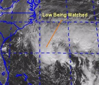
It appears the end of the 2000 hurricane season is getting near.� Although
the official end is not until November 30th.� It is kind of quiet out in
the tropics with just a low pressure system 500 miles south west of the Cape Verde
islands and looking good on satellite.� It is forecasted to encounter some
heavy shear, so immediate strengthening is not forecasted.
Comments or Questions? Everyone is invited to use it. Use the comment button by the story Headline.
NRL Monterey Marine Meteorology Division Forecast Track of Active Systems (Good Forecast Track Graphic and Satellite Photos)
Map with nearly all model projected tracks plotted for Keith.
From Michael Bryson.
Crown Weather Services Tropical Update (Includes Map with multiple forecast model tracks)
Snonut's Hurricane Reports
Other commentary at: Mike Anderson's East Coast Tropical Weather Center - Stormwarn2000 - SCOTTSVB's Hurricane Update Center - Jim Williams' Hurricane City - Gary Gray's Millennium Weather - Even More on our Links Page
- Satellite images at:
[Visible] (visible -- Daytime Only) [Infrared] (infrared), and [Water Vapor] (water vapor)
- Loops: Visible
Loop - Infrared
Loop - Water
Vapor Loop
NASA GHCC Interactive Satellite images at:
[NAtl visible] (visible -- Daytime Only) [NAtl infrared] (infrared), and [NAtl water vapor] (water vapor)--Nasa source.
Defiant Visible Infrared More...
Ocean Surface Winds Derived from the SeaWinds Scatterometer (Experimental)
Tormenta.net Espa�ol -- Gran informaci�n sobre huracanes aqu�.
Live Webcam image from Florida Emergency Management's Emergency Operations Center
Florida Emergency Management Activation Page / Situation Updates
Some Forecast models:
(NGM, AVN, MRF, ECMWF, ETA)
DoD weather models (NOGAPS, AVN, MRF)
AVN, ECMWF, GFDL, NOGAPS, UKMET
- [jc]
Leslie and Keith
08:44 AM EDT - 06 October 2000
| Three Comments | Read Comments | Newest: 07:53 PM 10-06 EDT
Leslie is heading away and will pass by Bermuda later on. Most of the convection in Leslie is to the south and east, so they've put up Tropical Storm Warnings for Leslie.
The last advisory on Keith was issued this morning. It's raining itself out in Northeast Mexico currently. Plenty of Rain for them.
Outside of that, it's strangely quiet. The only peep being in the East Atlantic. But that wave will not have a chance to develop because of the shearing going on that direction.
For the moment, all else is quiet. The season is not over, however. So we'll be watching.
Comments or Questions? Everyone is invited to use it. Use the comment button by the story Headline.
NRL Monterey Marine Meteorology Division Forecast Track of Active Systems (Good Forecast Track Graphic and Satellite Photos)
Map with nearly all model projected tracks plotted for Keith.
From Michael Bryson.
Crown Weather Services Tropical Update (Includes Map with multiple forecast model tracks)
Snonut's Hurricane Reports
Other commentary at: Mike Anderson's East Coast Tropical Weather Center - Stormwarn2000 - SCOTTSVB's Hurricane Update Center - Jim Williams' Hurricane City - Gary Gray's Millennium Weather - Even More on our Links Page
- Satellite images at:
[Visible] (visible -- Daytime Only) [Infrared] (infrared), and [Water Vapor] (water vapor)
- Loops: Visible
Loop - Infrared
Loop - Water
Vapor Loop
NASA GHCC Interactive Satellite images at:
[NAtl visible] (visible -- Daytime Only) [NAtl infrared] (infrared), and [NAtl water vapor] (water vapor)--Nasa source.
Defiant Visible Infrared More...
Ocean Surface Winds Derived from the SeaWinds Scatterometer (Experimental)
Tormenta.net Espa�ol -- Gran informaci�n sobre huracanes aqu�.
Live Webcam image from Florida Emergency Management's Emergency Operations Center
Florida Emergency Management Activation Page / Situation Updates
Some Forecast models:
(NGM, AVN, MRF, ECMWF, ETA)
DoD weather models (NOGAPS, AVN, MRF)
AVN, ECMWF, GFDL, NOGAPS, UKMET
- [mac]
SubTD#1 Becomes Tropical Storm Leslie
11:07 AM EDT - 05 October 2000
| Four Comments | Read Comments | Newest: 01:28 PM 10-05 EDT
Leslie has formed, and is moving away from the US. Not much else to say here. It is highly unlikely that it could affect land.
Keith is almost on land again, moving into Mexico.
Comments or Questions? Everyone is invited to use it. Use the comment button by the story Headline.
NRL Monterey Marine Meteorology Division Forecast Track of Active Systems (Good Forecast Track Graphic and Satellite Photos)
Map with nearly all model projected tracks plotted for Keith.
From Michael Bryson.
Crown Weather Services Tropical Update (Includes Map with multiple forecast model tracks)
Snonut's Hurricane Reports
Other commentary at: Mike Anderson's East Coast Tropical Weather Center - Stormwarn2000 - SCOTTSVB's Hurricane Update Center - Jim Williams' Hurricane City - Gary Gray's Millennium Weather - Even More on our Links Page
- Satellite images at:
[Visible] (visible -- Daytime Only) [Infrared] (infrared), and [Water Vapor] (water vapor)
- Loops: Visible
Loop - Infrared
Loop - Water
Vapor Loop
NASA GHCC Interactive Satellite images at:
[NAtl visible] (visible -- Daytime Only) [NAtl infrared] (infrared), and [NAtl water vapor] (water vapor)--Nasa source.
Defiant Visible Infrared More...
Ocean Surface Winds Derived from the SeaWinds Scatterometer (Experimental)
Tormenta.net Espa�ol -- Gran informaci�n sobre huracanes aqu�.
Live Webcam image from Florida Emergency Management's Emergency Operations Center
Florida Emergency Management Activation Page / Situation Updates
Some Forecast models:
(NGM, AVN, MRF, ECMWF, ETA)
DoD weather models (NOGAPS, AVN, MRF)
AVN, ECMWF, GFDL, NOGAPS, UKMET
- [mac]
Keith Hurricane Once Again and SUBTD
05:58 AM EDT - 05 October 2000
| Five Comments | Read Comments | Newest: 06:47 PM 10-05 EDT
Keith, once again, has become a Hurricane. Again, before landfall, moving west northwest toward the Mexican Coast. It has come back a little better than I expected. Folks along the eastern Mexican coast have Hurricane Warnings to deal with. As a minimal Hurricane, it will cause some minor damage and plenty of rain.
Speaking of plenty of rain, SubTD#1, which cause oh so much rain in Florida, is heading generally east away from the US. The "SubTD" snuck up on a lot of us and caused quite a bit of flooding. Outside of this there is nothing much going on.
Comments or Questions? Everyone is invited to use it. Use the comment button by the story Headline.
NRL Monterey Marine Meteorology Division Forecast Track of Active Systems (Good Forecast Track Graphic and Satellite Photos)
Map with nearly all model projected tracks plotted for Keith.
From Michael Bryson.
Crown Weather Services Tropical Update (Includes Map with multiple forecast model tracks)
Snonut's Hurricane Reports
Other commentary at: Mike Anderson's East Coast Tropical Weather Center - Stormwarn2000 - SCOTTSVB's Hurricane Update Center - Jim Williams' Hurricane City - Gary Gray's Millennium Weather - Even More on our Links Page
- Satellite images at:
[Visible] (visible -- Daytime Only) [Infrared] (infrared), and [Water Vapor] (water vapor)
- Loops: Visible
Loop - Infrared
Loop - Water
Vapor Loop
NASA GHCC Interactive Satellite images at:
[NAtl visible] (visible -- Daytime Only) [NAtl infrared] (infrared), and [NAtl water vapor] (water vapor)--Nasa source.
Defiant Visible Infrared More...
Ocean Surface Winds Derived from the SeaWinds Scatterometer (Experimental)
Tormenta.net Espa�ol -- Gran informaci�n sobre huracanes aqu�.
Live Webcam image from Florida Emergency Management's Emergency Operations Center
Florida Emergency Management Activation Page / Situation Updates
Some Forecast models:
(NGM, AVN, MRF, ECMWF, ETA)
DoD weather models (NOGAPS, AVN, MRF)
AVN, ECMWF, GFDL, NOGAPS, UKMET
- [mac]
Keith Tropical Storm. SubTD#1?
04:50 PM EDT - 04 October 2000
| Thirteen Comments | Read Comments | Newest: 11:46 PM 10-04 EDT
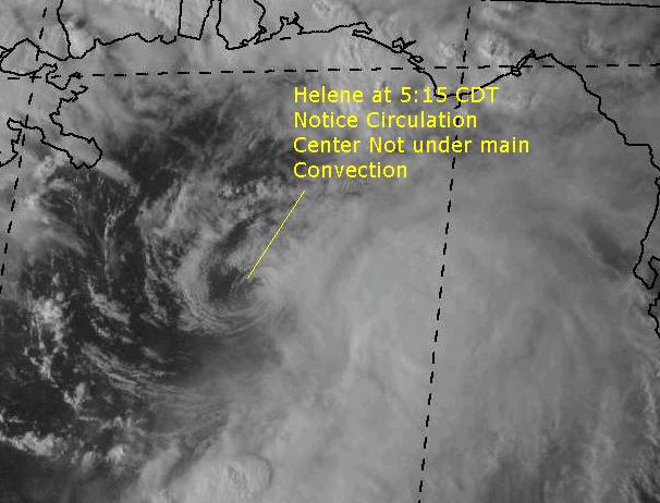
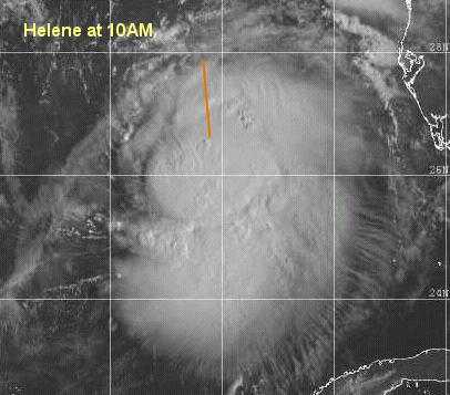
Ok, here's a new curveball I just didn't know about. The NHC tracking "subtropical" depressions. Or what it's calling the thing off the Florida East Coast near Daytona Beach. A Subtropical system has a much larger windfield than a normal tropical system, and sometimes they can form into tropical systems. This is new to me (the fact that the Hurricane Center calls it this), so comments on it are welcome. Anyway "Sub Tropical Depression #1" has formed off the Florida East Coast and more will come later on it. (It plays havoc with the automated code here though, overjoy)
Keith has reformed into a Tropical Storm and will remain that way as it enters the Mexican Coastline...
More will come later.
Comments or Questions? Everyone is invited to use it. Use the comment button by the story Headline.
NRL Monterey Marine Meteorology Division Forecast Track of Active Systems (Good Forecast Track Graphic and Satellite Photos)
Map with nearly all model projected tracks plotted for Keith.
From Michael Bryson.
Crown Weather Services Tropical Update (Includes Map with multiple forecast model tracks)
Snonut's Hurricane Reports
Other commentary at: Mike Anderson's East Coast Tropical Weather Center - Stormwarn2000 - SCOTTSVB's Hurricane Update Center - Jim Williams' Hurricane City - Gary Gray's Millennium Weather - Even More on our Links Page
- Satellite images at:
[Visible] (visible -- Daytime Only) [Infrared] (infrared), and [Water Vapor] (water vapor)
- Loops: Visible
Loop - Infrared
Loop - Water
Vapor Loop
NASA GHCC Interactive Satellite images at:
[NAtl visible] (visible -- Daytime Only) [NAtl infrared] (infrared), and [NAtl water vapor] (water vapor)--Nasa source.
Defiant Visible Infrared More...
Ocean Surface Winds Derived from the SeaWinds Scatterometer (Experimental)
Tormenta.net Espa�ol -- Gran informaci�n sobre huracanes aqu�.
Live Webcam image from Florida Emergency Management's Emergency Operations Center
Florida Emergency Management Activation Page / Situation Updates
Some Forecast models:
(NGM, AVN, MRF, ECMWF, ETA)
DoD weather models (NOGAPS, AVN, MRF)
AVN, ECMWF, GFDL, NOGAPS, UKMET
- [mac]
Keith Back Over Water
07:29 AM EDT - 04 October 2000
| Eleven Comments | Read Comments | Newest: 05:22 PM 10-04 EDT
Keith did not travel north into the Central Gulf as was projected by the NHC last week. They did mention this possibility, though. It's now moving west northwest over water toward the Mexican coastline. It will probably restrengthen during the day and may spawn watches or warnings on the Mexican coastline. Keith turned out to be a big problem for Belize, but for us, it may not. Mexico still will have to deal with it. In the off chance it still decides to play something strange, we'll continue to suggest the rest of the western Gulf to watch it.
Joyce won't regenerate. The low area around Florida will cause rain, and may develop slowly as it moves over water. And there's nothing else worth talking about at the moment.
Comments or Questions? Everyone is invited to use it. Use the comment button by the story Headline.
NRL Monterey Marine Meteorology Division Forecast Track of Active Systems (Good Forecast Track Graphic and Satellite Photos)
Map with nearly all model projected tracks plotted for Keith.
From Michael Bryson.
Crown Weather Services Tropical Update (Includes Map with multiple forecast model tracks)
Snonut's Hurricane Reports
Other commentary at: Mike Anderson's East Coast Tropical Weather Center - Stormwarn2000 - SCOTTSVB's Hurricane Update Center - Jim Williams' Hurricane City - Gary Gray's Millennium Weather - Even More on our Links Page
- Satellite images at:
[Visible] (visible -- Daytime Only) [Infrared] (infrared), and [Water Vapor] (water vapor)
- Loops: Visible
Loop - Infrared
Loop - Water
Vapor Loop
NASA GHCC Interactive Satellite images at:
[NAtl visible] (visible -- Daytime Only) [NAtl infrared] (infrared), and [NAtl water vapor] (water vapor)--Nasa source.
Defiant Visible Infrared More...
Ocean Surface Winds Derived from the SeaWinds Scatterometer (Experimental)
Tormenta.net Espa�ol -- Gran informaci�n sobre huracanes aqu�.
Live Webcam image from Florida Emergency Management's Emergency Operations Center
Florida Emergency Management Activation Page / Situation Updates
Some Forecast models:
(NGM, AVN, MRF, ECMWF, ETA)
DoD weather models (NOGAPS, AVN, MRF)
AVN, ECMWF, GFDL, NOGAPS, UKMET
- [mac]
Keith Tropical Storm
06:52 AM EDT - 03 October 2000
| Eighteen Comments | Read Comments | Newest: 10:07 PM 10-03 EDT
Keith is now over land and finally moving, just a bit, toward the Northwest. The National Hurricane Center thinks it will reemerge in the Central Gulf and head generally northward. I tend to agree now. And restrengthen into hurricane status when it does. Keith continues to be a problem.
The remnants of Joyce are looking very poor this morning, so I don't see anything reoccuring with it.
The low just south of Florida looks like it may try to build into something tropical, but I doubt it will get strong enough to cause anything other than more rain for Florida.
Comments or Questions? Everyone is invited to use it. Use the comment button by the story Headline.
NRL Monterey Marine Meteorology Division Forecast Track of Active Systems (Good Forecast Track Graphic and Satellite Photos)
Map with nearly all model projected tracks plotted for Isaac., Joyce, or Keith
From Michael Bryson.
Crown Weather Services Tropical Update (Includes Map with multiple forecast model tracks)
Snonut's Hurricane Reports
Other commentary at: Mike Anderson's East Coast Tropical Weather Center - Stormwarn2000 - SCOTTSVB's Hurricane Update Center - Jim Williams' Hurricane City - Gary Gray's Millennium Weather - Even More on our Links Page
- Satellite images at:
[Visible] (visible -- Daytime Only) [Infrared] (infrared), and [Water Vapor] (water vapor)
- Loops: Visible
Loop - Infrared
Loop - Water
Vapor Loop
NASA GHCC Interactive Satellite images at:
[NAtl visible] (visible -- Daytime Only) [NAtl infrared] (infrared), and [NAtl water vapor] (water vapor)--Nasa source.
Defiant Visible Infrared More...
Ocean Surface Winds Derived from the SeaWinds Scatterometer (Experimental)
StormCarib.com has reports from folks in the Caribbean islands themselves and is worth checking out when storms approach the Caribbean.
Ouragans.com Fran�ais -- L'information sur des ouragans comprenant beaucoup de liens.
Tormenta.net Espa�ol -- Gran informaci�n sobre huracanes aqu�.
Live Webcam image from Florida Emergency Management's Emergency Operations Center
Florida Emergency Management Activation Page / Situation Updates
Some Forecast models:
(NGM, AVN, MRF, ECMWF, ETA)
DoD weather models (NOGAPS, AVN, MRF)
AVN, ECMWF, GFDL, NOGAPS, UKMET
- [mac]
Interesting Developments
04:26 PM EDT - 02 October 2000
| Twelve Comments | Read Comments | Newest: 01:48 AM 10-03 EDT
Keith is still weakening near the coast, and still not moving. Joyce dissipated, but may regenerate. (50/50 chance) The folks in Belize have received a huge amount of rain and wind the last few days.
An area south of Cuba along with a cold front is causing a great deal of rain in South Florida. There is a chance that something minimal could form south of Cuba. That along with Keith and Ex-Joyce will make it somewhat interesting, but nothing in the extreme danger category (Like Keith was a few days ago)looks likely.
Comments or Questions? Everyone is invited to use it. Use the comment button by the story Headline.
NRL Monterey Marine Meteorology Division Forecast Track of Active Systems (Good Forecast Track Graphic and Satellite Photos)
Map with nearly all model projected tracks plotted for Isaac., Joyce, or Keith
From Michael Bryson.
Crown Weather Services Tropical Update (Includes Map with multiple forecast model tracks)
Snonut's Hurricane Reports
Other commentary at: Mike Anderson's East Coast Tropical Weather Center - Stormwarn2000 - SCOTTSVB's Hurricane Update Center - Jim Williams' Hurricane City - Gary Gray's Millennium Weather - Even More on our Links Page
- Satellite images at:
[Visible] (visible -- Daytime Only) [Infrared] (infrared), and [Water Vapor] (water vapor)
- Loops: Visible
Loop - Infrared
Loop - Water
Vapor Loop
NASA GHCC Interactive Satellite images at:
[NAtl visible] (visible -- Daytime Only) [NAtl infrared] (infrared), and [NAtl water vapor] (water vapor)--Nasa source.
Defiant Visible Infrared More...
Ocean Surface Winds Derived from the SeaWinds Scatterometer (Experimental)
StormCarib.com has reports from folks in the Caribbean islands themselves and is worth checking out when storms approach the Caribbean.
Ouragans.com Fran�ais -- L'information sur des ouragans comprenant beaucoup de liens.
Tormenta.net Espa�ol -- Gran informaci�n sobre huracanes aqu�.
Live Webcam image from Florida Emergency Management's Emergency Operations Center
Florida Emergency Management Activation Page / Situation Updates
Some Forecast models:
(NGM, AVN, MRF, ECMWF, ETA)
DoD weather models (NOGAPS, AVN, MRF)
AVN, ECMWF, GFDL, NOGAPS, UKMET
- [mac]
Keith/Joyce
04:57 AM EDT - 02 October 2000
| Thirty-eight Comments | Read Comments | Last 20 Comments | Newest: 07:07 PM 10-02 EDT
This morning Keith has been in a weird position. It has been half over land and half over water. And with not moving much at all last night, has had the land (and everone on it, unfortunately) take its toll on the hurricane's structure. It hasn't moved one bit, and still continues to pound Belize. It's future track is still projected by the National Hurricane Center to eventually head north over the peninsula and into the Gulf as a Tropical Storm. Keith's non-movement may be good for the US, but it's been a nightmare for the folks in Belize. So it's not the best solution.
Joyce is now projected to be a Tropical Storm in about 72 hours south of Cuba in the Western Caribbean, so we'll have that to watch as well. Any interaction between Keith and Joyce could make things interesting later down the road. We'll be watching.
Comments or Questions? Everyone is invited to use it. Use the comment button by the story Headline.
NRL Monterey Marine Meteorology Division Forecast Track of Active Systems (Good Forecast Track Graphic and Satellite Photos)
Map with nearly all model projected tracks plotted for Isaac., Joyce, or Keith
From Michael Bryson.
Crown Weather Services Tropical Update (Includes Map with multiple forecast model tracks)
Snonut's Hurricane Reports
Other commentary at: Mike Anderson's East Coast Tropical Weather Center - Stormwarn2000 - SCOTTSVB's Hurricane Update Center - Jim Williams' Hurricane City - Gary Gray's Millennium Weather - Even More on our Links Page
- Satellite images at:
[Visible] (visible -- Daytime Only) [Infrared] (infrared), and [Water Vapor] (water vapor)
- Loops: Visible
Loop - Infrared
Loop - Water
Vapor Loop
NASA GHCC Interactive Satellite images at:
[NAtl visible] (visible -- Daytime Only) [NAtl infrared] (infrared), and [NAtl water vapor] (water vapor)--Nasa source.
Defiant Visible Infrared More...
Ocean Surface Winds Derived from the SeaWinds Scatterometer (Experimental)
StormCarib.com has reports from folks in the Caribbean islands themselves and is worth checking out when storms approach the Caribbean.
Ouragans.com Fran�ais -- L'information sur des ouragans comprenant beaucoup de liens.
Tormenta.net Espa�ol -- Gran informaci�n sobre huracanes aqu�.
Live Webcam image from Florida Emergency Management's Emergency Operations Center
Florida Emergency Management Activation Page / Situation Updates
Some Forecast models:
(NGM, AVN, MRF, ECMWF, ETA)
DoD weather models (NOGAPS, AVN, MRF)
AVN, ECMWF, GFDL, NOGAPS, UKMET
- [mac]
Keith Pounds as it Weakens, Joyce TD
05:24 PM EDT - 01 October 2000
Jim Williams WABN/Hurricane City is doing a live broadcast right now.
Hurricane Keith, with the west side of the Eyewall over land. Has weakened a bit during the afternoon back to a still major Category 3 system. The dynamics have changed a bit and now the NHC calls for it to move over the Yucatan and weaken to reemerge in the Gulf as a mid-strong Tropical Storm. This is better than the other possible scenario which included it heading up almost due north missing most of the land. However, Belize and the Yucatan of Mexico is getting truly hammered now, and has been all day. Keith is still the number one concern. The entire Gulf coast will have to watch it.
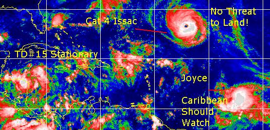
Joyce is been downgraded to a Tropical Depression, and now sits just north of South America in the Caribbean. It's going to be moving through a historically poor area for Storms, so it may remain weak until it gets through this area in the East Caribbean. Later on, Joyce will become yet another concern in the Western Caribbean.
Isaac had its last advisory issued at 11AM this morning. It's now an extratropical low heading away in the northern latitudes.
Hurricane Keith photos from Ambergris Caye
Hurricane Information Bulletin Board for Belize and Ambergis Caye
Comments or Questions? Everyone is invited to use it. Use the comment button by the story Headline.
NRL Monterey Marine Meteorology Division Forecast Track of Active Systems (Good Forecast Track Graphic and Satellite Photos)
Map with nearly all model projected tracks plotted for Isaac., Joyce, or Keith
From Michael Bryson.
Crown Weather Services Tropical Update (Includes Map with multiple forecast model tracks)
Snonut's Hurricane Reports
Other commentary at: Mike Anderson's East Coast Tropical Weather Center - Stormwarn2000 - SCOTTSVB's Hurricane Update Center - Jim Williams' Hurricane City - Gary Gray's Millennium Weather - Even More on our Links Page
- Satellite images at:
[Visible] (visible -- Daytime Only) [Infrared] (infrared), and [Water Vapor] (water vapor)
- Loops: Visible
Loop - Infrared
Loop - Water
Vapor Loop
NASA GHCC Interactive Satellite images at:
[NAtl visible] (visible -- Daytime Only) [NAtl infrared] (infrared), and [NAtl water vapor] (water vapor)--Nasa source.
Defiant Visible Infrared More...
Ocean Surface Winds Derived from the SeaWinds Scatterometer (Experimental)
StormCarib.com has reports from folks in the Caribbean islands themselves and is worth checking out when storms approach the Caribbean.
Ouragans.com Fran�ais -- L'information sur des ouragans comprenant beaucoup de liens.
Tormenta.net Espa�ol -- Gran informaci�n sobre huracanes aqu�.
Live Webcam image from Florida Emergency Management's Emergency Operations Center
Florida Emergency Management Activation Page / Situation Updates
Some Forecast models:
(NGM, AVN, MRF, ECMWF, ETA)
DoD weather models (NOGAPS, AVN, MRF)
AVN, ECMWF, GFDL, NOGAPS, UKMET
- [mac]
Category 4 Hurricane Keith Still Moving Little
07:10 AM EDT - 01 October 2000
| Thirty-two Comments | Read Comments | Last 20 Comments | Newest: 04:31 PM 10-01 EDT
Keith is an amazing looking system. The folks along the Yucuatan's eastern coast are getting pounded right now. Keith is just sitting and spinning in very warm waters. It's still projected to head north, over land for a bit in the Yucatan and then into the central Gulf. What else can I say besides watch the system closely. Its slow movement prevents any serious future track talk, so the Gulf needs to watch out. I do expect it to weaken a bit over land (depends on how long it stays over land too), but not enough to get it below hurricane status.
Joyce is barely holding together and moving into the Caribbean, it may strengthen slightly once in the East Caribbean waters, but for now I'll minimize its importance.
Comments or Questions? Everyone is invited to use it. Use the comment button by the story Headline.
NRL Monterey Marine Meteorology Division Forecast Track of Active Systems (Good Forecast Track Graphic and Satellite Photos)
Map with nearly all model projected tracks plotted for Isaac., Joyce, or Keith
From Michael Bryson.
Crown Weather Services Tropical Update (Includes Map with multiple forecast model tracks)
Snonut's Hurricane Reports
Other commentary at: Mike Anderson's East Coast Tropical Weather Center - Stormwarn2000 - SCOTTSVB's Hurricane Update Center - Jim Williams' Hurricane City - Gary Gray's Millennium Weather - Even More on our Links Page
- Satellite images at:
[Visible] (visible -- Daytime Only) [Infrared] (infrared), and [Water Vapor] (water vapor)
- Loops: Visible
Loop - Infrared
Loop - Water
Vapor Loop
NASA GHCC Interactive Satellite images at:
[NAtl visible] (visible -- Daytime Only) [NAtl infrared] (infrared), and [NAtl water vapor] (water vapor)--Nasa source.
Defiant Visible Infrared More...
Ocean Surface Winds Derived from the SeaWinds Scatterometer (Experimental)
StormCarib.com has reports from folks in the Caribbean islands themselves and is worth checking out when storms approach the Caribbean.
Ouragans.com Fran�ais -- L'information sur des ouragans comprenant beaucoup de liens.
Tormenta.net Espa�ol -- Gran informaci�n sobre huracanes aqu�.
Live Webcam image from Florida Emergency Management's Emergency Operations Center
Florida Emergency Management Activation Page / Situation Updates
Some Forecast models:
(NGM, AVN, MRF, ECMWF, ETA)
DoD weather models (NOGAPS, AVN, MRF)
AVN, ECMWF, GFDL, NOGAPS, UKMET
- [mac]
Keith Strengthens
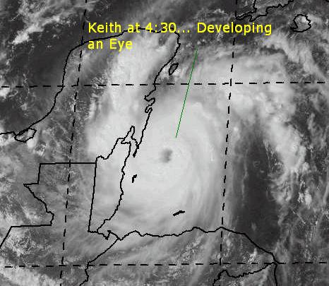
04:46 PM EDT - 30 September 2000
| Twenty-two Comments | Read Comments | Last 20 Comments | Newest: 06:47 AM 10-01 EDT
Hurricane Keith has developed an Eye and is looking very impressive on the satellite. It has strengthened to a category 2 hurricane with 100MPH winds. It is projected to clip the NE tip of the Yucatan moving North Northwest as a Category 3 storm.
Keith's movement is still almost non-existant. Belize still has Hurricane Warnings up, and the Yucatan as well. Trends still suggest that it will wind up in the Gulf and eventually affect land between Lousiana and the Western coast of Florida. Keith has the potential to be one of the few "event" storms, so all eyes need to be on it anywhere in the Northwest Caribbean and Gulf. To be painfully redundant, it still isn't moving and until a trend is spotted it is all speculation. This may take a few days, so we'll be watching it very very closely.
Joyce is still a very weak tropical storm and may have trouble surviving into the Caribbean. Its weakened state has allowed it to slide westward and into the Caribbean. I'm not sure it will ever restregthen, but it will need to be watched. Isaac's nearing the end of its life as a tropical system, and will soon be an extratropical one.
More thoughts to come on this as time goes by...
Comments or Questions? Everyone is invited to use it. Use the comment button by the story Headline.
NRL Monterey Marine Meteorology Division Forecast Track of Active Systems (Good Forecast Track Graphic and Satellite Photos)
Map with nearly all model projected tracks plotted for Isaac., Joyce, or Keith
From Michael Bryson.
Crown Weather Services Tropical Update (Includes Map with multiple forecast model tracks)
Snonut's Hurricane Reports
Other commentary at: Mike Anderson's East Coast Tropical Weather Center - Stormwarn2000 - SCOTTSVB's Hurricane Update Center - Jim Williams' Hurricane City - Gary Gray's Millennium Weather - Even More on our Links Page
- Satellite images at:
[Visible] (visible -- Daytime Only) [Infrared] (infrared), and [Water Vapor] (water vapor)
- Loops: Visible
Loop - Infrared
Loop - Water
Vapor Loop
NASA GHCC Interactive Satellite images at:
[NAtl visible] (visible -- Daytime Only) [NAtl infrared] (infrared), and [NAtl water vapor] (water vapor)--Nasa source.
Defiant Visible Infrared More...
Ocean Surface Winds Derived from the SeaWinds Scatterometer (Experimental)
StormCarib.com has reports from folks in the Caribbean islands themselves and is worth checking out when storms approach the Caribbean.
Ouragans.com Fran�ais -- L'information sur des ouragans comprenant beaucoup de liens.
Tormenta.net Espa�ol -- Gran informaci�n sobre huracanes aqu�.
Live Webcam image from Florida Emergency Management's Emergency Operations Center
Florida Emergency Management Activation Page / Situation Updates
Some Forecast models:
(NGM, AVN, MRF, ECMWF, ETA)
DoD weather models (NOGAPS, AVN, MRF)
AVN, ECMWF, GFDL, NOGAPS, UKMET
- [mac]
Keith Now Hurricane In Northwest Caribbean
11:02 AM EDT - 30 September 2000
| Sixteen Comments | Read Comments | Newest: 04:47 PM 09-30 EDT
Keith now has a very impressive looking eye.. 5PM updates forthcoming...
Keith has been upgraded to a Category 1 Hurricane with 80MPH Winds.
It is expected to move slowly north northwest and cross the Northeast section of the Yucatan peninsula. Probably as a Category 2 system. Currently the NHC's calling its movement as meandering. I expect Keith to weaken a bit while its over land, but not below strong Tropical Storm strength, to reemerge in the Gulf of Mexico and reform into a Hurricane. Mexico has issued Hurricane Warnings now for the North coast of the Yucatan. Folks in the Gulf (Especially Florida, Alabama and Louisiana) will want to watch this one closely, as things could change. Keith is starting to look very good on satellite as well. So there is a chance it could deepen more rapidly than expected. Folks in the Yucatan will be advised to prepare now, if you haven't already.
A big caveat with the prediction of the North Northwest movement involves past history with Hurricane Mitch [ Visible Sat of Mitch (1998)]. Models wanted to take that storm to the north, but it eventually meandered toward the west. Becoming a category 5 system and devistating that part of Central America. Mitch caused more deaths than any Atlantic storm previously. Therefore, the NNW solution is not the only solution. Mitch was further south than Keith at the time. But Belize needs to know about this possibility.
Joyce is moving more westward and will be in the southern winward islands tomorrow. I don't think it will regain hurricane strength when it arrives there. After that it's too soon to tell.
Comments or Questions? Everyone is invited to use it. Use the comment button by the story Headline.
NRL Monterey Marine Meteorology Division Forecast Track of Active Systems (Good Forecast Track Graphic and Satellite Photos)
Map with nearly all model projected tracks plotted for Isaac., Joyce, or Keith
From Michael Bryson.
Crown Weather Services Tropical Update (Includes Map with multiple forecast model tracks)
Snonut's Hurricane Reports
Other commentary at: Mike Anderson's East Coast Tropical Weather Center - Stormwarn2000 - SCOTTSVB's Hurricane Update Center - Jim Williams' Hurricane City - Gary Gray's Millennium Weather - Even More on our Links Page
- Satellite images at:
[Visible] (visible -- Daytime Only) [Infrared] (infrared), and [Water Vapor] (water vapor)
- Loops: Visible
Loop - Infrared
Loop - Water
Vapor Loop
NASA GHCC Interactive Satellite images at:
[NAtl visible] (visible -- Daytime Only) [NAtl infrared] (infrared), and [NAtl water vapor] (water vapor)--Nasa source.
Ocean Surface Winds Derived from the SeaWinds Scatterometer (Experimental)
StormCarib.com has reports from folks in the Caribbean islands themselves and is worth checking out when storms approach the Caribbean.
Ouragans.com Fran�ais -- L'information sur des ouragans comprenant beaucoup de liens.
Tormenta.net Espa�ol -- Gran informaci�n sobre huracanes aqu�.
Live Webcam image from Florida Emergency Management's Emergency Operations Center
Florida Emergency Management Activation Page / Situation Updates
Some Forecast models:
(NGM, AVN, MRF, ECMWF, ETA)
DoD weather models (NOGAPS, AVN, MRF)
AVN, ECMWF, GFDL, NOGAPS, UKMET
- [mac]
Near-Hurricane Keith.... Joyce
07:47 AM EDT - 30 September 2000
| Eighteen Comments | Read Comments | Newest: 11:31 AM 09-30 EDT
This morning, everyone is wondering about Keith and Joyce.
We'll start with Joyce for our friends in the East Caribbean. Joyce is weakened, but making a little bit of a rebound. Since Joyce had stayed weak, it has kept a more west track and will now probably enter the Caribbean itself crossing over the eastern islands as a strong Tropical Storm. Interests there must be prepared. In fact, there is a tropical storm watch for Barbados, St. Vincent, St. Lucia, Trinidad, Tobago and Grenada. It's keeping south!
Now Keith... nearing Hurricane Strength, is still drifting somewhat slowly. The latest official projections have it clipping the NE coast of the Yucatan. So therefore a hurricane Warning is up the entire east coast of the Yucatan peninsula (Belize border north to Cabo Catoche) And a Tropical Storm warning is in effect for much of Belize.
After it clips, it is projected to take a long clockwise semi-loop in the Gulf. Which places it near the center of the Gulf of Mexico in 72 hours. After this, it is likely to bend back toward the east. At this point it becomes conjecture, but for the moment Florida's west coast may be under the gun from Keith. However, all the Gulf will need to watch. This season is known for strange things.
When in doubt, take the word of the National Hurricane Center and local officials.
Comments or Questions? Everyone is invited to use it. Use the comment button by the story Headline.
NRL Monterey Marine Meteorology Division Forecast Track of Active Systems (Good Forecast Track Graphic and Satellite Photos)
Map with nearly all model projected tracks plotted for Isaac., Joyce, or Keith
From Michael Bryson.
Crown Weather Services Tropical Update (Includes Map with multiple forecast model tracks)
Snonut's Hurricane Reports
Other commentary at: Mike Anderson's East Coast Tropical Weather Center - Stormwarn2000 - SCOTTSVB's Hurricane Update Center - Jim Williams' Hurricane City - Gary Gray's Millennium Weather - Even More on our Links Page
- Satellite images at:
[Visible] (visible -- Daytime Only) [Infrared] (infrared), and [Water Vapor] (water vapor)
- Loops: Visible
Loop - Infrared
Loop - Water
Vapor Loop
NASA GHCC Interactive Satellite images at:
[NAtl visible] (visible -- Daytime Only) [NAtl infrared] (infrared), and [NAtl water vapor] (water vapor)--Nasa source.
Ocean Surface Winds Derived from the SeaWinds Scatterometer (Experimental)
StormCarib.com has reports from folks in the Caribbean islands themselves and is worth checking out when storms approach the Caribbean.
Ouragans.com Fran�ais -- L'information sur des ouragans comprenant beaucoup de liens.
Tormenta.net Espa�ol -- Gran informaci�n sobre huracanes aqu�.
Live Webcam image from Florida Emergency Management's Emergency Operations Center
Florida Emergency Management Activation Page / Situation Updates
Some Forecast models:
(NGM, AVN, MRF, ECMWF, ETA)
DoD weather models (NOGAPS, AVN, MRF)
AVN, ECMWF, GFDL, NOGAPS, UKMET
- [mac]
Tropical Storm Keith Forms in Northwest Caribbean
02:38 PM EDT - 29 September 2000
| Fourty-three Comments | Read Comments | Last 20 Comments | Newest: 04:09 AM 09-30 EDT
8PM Update:
Keith is still drifting toward the Nortwest, Joyce is looking to head into the Caribbean Islands... It will be a busy next few days here at CFHC. Keith has the potential to be very strong, so it's the one to watch for us as it has a chance of affecting Florida later on. In fact, Hurricane Watches are already up on the east coast of the Yucatan Peninsula in Mexico.
Original Update:
According to the special update from the Hurricane Center, Keith is now a Tropical Storm. Hurricane Hunter aircraft in the area have found strong enough winds and a good circulation to make this possible. In the last few hours, Keith has started to look a lot better. At 5PM the first advisories for the new Tropical Storm will be out. There may be watches issued along the Northwest Caribbean.
Keith has remained stationary, and probably will for a while. I eventually think it will nudge northward, but long term all bets are off. Along with a slightly weakened Joyce, we'll have two potential threats to land to track over the next several days.
More to come later.
Comments or Questions? Everyone is invited to use it. Use the comment button by the story Headline.
NRL Monterey Marine Meteorology Division Forecast Track of Active Systems (Good Forecast Track Graphic and Satellite Photos)
Map with nearly all model projected tracks plotted for Isaac., Joyce, or Keith
From Michael Bryson.
Crown Weather Services Tropical Update (Includes Map with multiple forecast model tracks)
Snonut's Hurricane Reports
Other commentary at: Mike Anderson's East Coast Tropical Weather Center - Stormwarn2000 - SCOTTSVB's Hurricane Update Center - Jim Williams' Hurricane City - Gary Gray's Millennium Weather - Even More on our Links Page
- Satellite images at:
[Visible] (visible -- Daytime Only) [Infrared] (infrared), and [Water Vapor] (water vapor)
- Loops: Visible
Loop - Infrared
Loop - Water
Vapor Loop
NASA GHCC Interactive Satellite images at:
[NAtl visible] (visible -- Daytime Only) [NAtl infrared] (infrared), and [NAtl water vapor] (water vapor)--Nasa source.
Ocean Surface Winds Derived from the SeaWinds Scatterometer (Experimental)
StormCarib.com has reports from folks in the Caribbean islands themselves and is worth checking out when storms approach the Caribbean.
Ouragans.com Fran�ais -- L'information sur des ouragans comprenant beaucoup de liens.
Tormenta.net Espa�ol -- Gran informaci�n sobre huracanes aqu�.
Live Webcam image from Florida Emergency Management's Emergency Operations Center
Florida Emergency Management Activation Page / Situation Updates
Some Forecast models:
(NGM, AVN, MRF, ECMWF, ETA)
DoD weather models (NOGAPS, AVN, MRF)
AVN, ECMWF, GFDL, NOGAPS, UKMET
- [mac]
Technical Problems
08:48 AM EDT - 29 September 2000
| Fourteen Comments | Read Comments | Newest: 10:22 PM 09-29 EDT
11:15AM Update:
Back Up!
Joyce has been downgraded to a Tropical Storm, as yet another storm seems to have its LLCC run out from under it. Strange...
Original Update:
The T1 line on which the FLHurricane server sits went down around 12:10AM this morning. There was a fiber cut on the Cox fiber line which caused this interruption. When it comes back up you should see this story. We apologize for the problems.
Joyce and Isaac are still looking very good. Joyce still looks like it may affect the Caribbean islands. TD#15 is very close to shore and mostly stationary. It will continue to be watched by folks in the Northwest Caribbean.
Comments or Questions? Everyone is invited to use it. Use the comment button by the story Headline.
NRL Monterey Marine Meteorology Division Forecast Track of Active Systems (Good Forecast Track Graphic and Satellite Photos)
Map with nearly all model projected tracks plotted for Isaac., Joyce, or TD#15
From Michael Bryson.
Crown Weather Services Tropical Update (Includes Map with multiple forecast model tracks)
Snonut's Hurricane Reports
- Satellite images at:
[Visible] (visible -- Daytime Only) [Infrared] (infrared), and [Water Vapor] (water vapor)
- Loops: Visible
Loop - Infrared
Loop - Water
Vapor Loop
NASA GHCC Interactive Satellite images at:
[NAtl visible] (visible -- Daytime Only) [NAtl infrared] (infrared), and [NAtl water vapor] (water vapor)--Nasa source.
Ocean Surface Winds Derived from the SeaWinds Scatterometer (Experimental)
StormCarib.com has reports from folks in the Caribbean islands themselves and is worth checking out when storms approach the Caribbean.
Ouragans.com Fran�ais -- L'information sur des ouragans comprenant beaucoup de liens.
Tormenta.net Espa�ol -- Gran informaci�n sobre huracanes aqu�.
Some Forecast models:
(NGM, AVN, MRF, ECMWF, ETA)
DoD weather models (NOGAPS, AVN, MRF)
AVN, ECMWF, GFDL, NOGAPS, UKMET
- [mac]
TD#15 Forms in Northwest Caribbean
05:38 PM EDT - 28 September 2000
| Fourteen Comments | Read Comments | Newest: 10:40 PM 09-29 EDT
Tropical Depression #15 is moving very slowly, and is basically stationary at the moment. I expect it to slowly move northwest and gradually strengthen into a hurricane. It would be Keith. It's slow movement will probably make it and Joyce stories in the future.
Isaac is just amazing. It's now a Category 4 system with 140MPH winds. Isaac, by far, is the most impressive looking storm of this season to date. Fortunately for everyone except sailors, it's a non-issue.
Joyce is starting to look as if it may have some sort of impact on the Northeast Caribbean Islands in roughly 3 to 4 days. It may skirt or cross, but it'll be a close call for sure. Folks in these islands will want to watch.
TD#15 is near Honduras right now and barely moving. There are no tropical storm watches or warnings yet, but folks in the Northwest Caribbean will want to watch it very closely. The rest of us will have to wait, as it is a slow mover, and will be hard to tell.
Comments or Questions? Everyone is invited to use it. Use the comment button by the story Headline.
NRL Monterey Marine Meteorology Division Forecast Track of Active Systems (Good Forecast Track Graphic and Satellite Photos)
Map with nearly all model projected tracks plotted for Isaac., Joyce, or TD#15
From Michael Bryson.
Crown Weather Services Tropical Update (Includes Map with multiple forecast model tracks)
Snonut's Hurricane Reports
- Satellite images at:
[Visible] (visible -- Daytime Only) [Infrared] (infrared), and [Water Vapor] (water vapor)
- Loops: Visible
Loop - Infrared
Loop - Water
Vapor Loop
NASA GHCC Interactive Satellite images at:
[NAtl visible] (visible -- Daytime Only) [NAtl infrared] (infrared), and [NAtl water vapor] (water vapor)--Nasa source.
Ocean Surface Winds Derived from the SeaWinds Scatterometer (Experimental)
StormCarib.com has reports from folks in the Caribbean islands themselves and is worth checking out when storms approach the Caribbean.
Ouragans.com Fran�ais -- L'information sur des ouragans comprenant beaucoup de liens.
Tormenta.net Espa�ol -- Gran informaci�n sobre huracanes aqu�.
Some Forecast models:
(NGM, AVN, MRF, ECMWF, ETA)
DoD weather models (NOGAPS, AVN, MRF)
AVN, ECMWF, GFDL, NOGAPS, UKMET
- [mac]
Isaac, Joyce, Caribbean
11:08 PM EDT - 27 September 2000
| Nineteen Comments | Read Comments | Newest: 10:35 PM 09-29 EDT
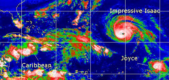
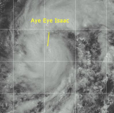
Tonight, after letting everything gel, we can finally see that Hurricane Isaac has once again strengthened into a major hurricane. Isaac has a very impressive Eye at the moment. The future still finds it a fish spinner, but worth checking out on the loops.
Joyce is a much more compact system and is really prone to rapid strengthening and weakening. It's moving generally toward the west, and some models nudge it a bit southwest for a bit before eventually turning back toward the Northwest. The northeast Caribbean islands will want to watch it. My guestimate still places it near the NW Caribbean islands late weekend. I must note that I do not think it will enter the Caribbean. I wish to note that it is not impossible for it to enter the Caribbean, either. Another possibility is that it gets sheared a bit and stays weak.
The system in the West Caribbean is slowly coming together. I think it has a chance to be another rain event for Florida. It could become a depression tomorrow or the next day. Otherwise, I cannot see it gaining enough strength to become too big a threat. Regardless, the "Tropical Apathy" of the last two storms shouldn't be a factor. Things could change. The remains of Helene, in fact, caused some flooding in Great Britain.
For the moment, Joyce remains the most interesting feature, followed by the Caribbean. For sheer appearance, Isaac also gets high marks.
Comments or Questions? Everyone is invited to use it. Use the comment button by the story Headline.
NRL Monterey Marine Meteorology Division Forecast Track of Active Systems (Good Forecast Track Graphic and Satellite Photos)
Map with nearly all model projected tracks plotted for Isaac. or Joyce
From Michael Bryson.
Crown Weather Services Tropical Update (Includes Map with multiple forecast model tracks)
Snonut's Hurricane Reports
- Satellite images at:
[Visible] (visible -- Daytime Only) [Infrared] (infrared), and [Water Vapor] (water vapor)
- Loops: Visible
Loop - Infrared
Loop - Water
Vapor Loop
NASA GHCC Interactive Satellite images at:
[NAtl visible] (visible -- Daytime Only) [NAtl infrared] (infrared), and [NAtl water vapor] (water vapor)--Nasa source.
Ocean Surface Winds Derived from the SeaWinds Scatterometer (Experimental)
StormCarib.com has reports from folks in the Caribbean islands themselves and is worth checking out when storms approach the Caribbean.
Ouragans.com Fran�ais -- L'information sur des ouragans comprenant beaucoup de liens.
Tormenta.net Espa�ol -- Gran informaci�n sobre huracanes aqu�.
Some Forecast models:
(NGM, AVN, MRF, ECMWF, ETA)
DoD weather models (NOGAPS, AVN, MRF)
AVN, ECMWF, GFDL, NOGAPS, UKMET
- [mac]
Hurricane Joyce and the Season
10:54 AM EDT - 27 September 2000
| Sixty-eight Comments | Read Comments | Last 20 Comments | Newest: 12:03 AM 09-28 EDT
Joyce has been upgraded to a hurricane, and continues to zip on toward the west at a pretty good clip. Joyce will have potential to affect the Caribbean later on, so it must be watched. The MRF does have it missing the islands to the north as it goes on a loop, though. But that's conjecture.
I thought that it would be good to note how active this season really has been. Regardless of a lot of storms that just went "poof", we are already up to the "J" storm this year. Which is as far as we got entirely last year. And there's still two months left in Hurricane Season.
The peak is over, but the potential is not.
We will continue to watch the tropics...
Comments or Questions? Everyone is invited to use it. Use the comment button by the story Headline.
NRL Monterey Marine Meteorology Division Forecast Track of Active Systems (Good Forecast Track Graphic and Satellite Photos)
Map with nearly all model projected tracks plotted for Isaac. or Joyce
From Michael Bryson.
Crown Weather Services Tropical Update (Includes Map with multiple forecast model tracks)
Snonut's Hurricane Reports
- Satellite images at:
[Visible] (visible -- Daytime Only) [Infrared] (infrared), and [Water Vapor] (water vapor)
- Loops: Visible
Loop - Infrared
Loop - Water
Vapor Loop
NASA GHCC Interactive Satellite images at:
[NAtl visible] (visible -- Daytime Only) [NAtl infrared] (infrared), and [NAtl water vapor] (water vapor)--Nasa source.
Ocean Surface Winds Derived from the SeaWinds Scatterometer (Experimental)
Tormenta.net Espa�ol -- Gran informaci�n sobre huracanes aqu�.
Some Forecast models:
(NGM, AVN, MRF, ECMWF, ETA)
DoD weather models (NOGAPS, AVN, MRF)
AVN, ECMWF, GFDL, NOGAPS, UKMET
- [mac]
Joyce
09:05 AM EDT - 26 September 2000
| Fourteen Comments | Read Comments | Newest: 10:45 AM 09-27 EDT
Tropical Storm Joyce has formed southeast of where Isaac's at. Joyce will be the one to watch over the next week or so, as it is expected to track due west further south than Isaac. This is yet another "wait and see" storm.
Isaac itself is still a strong hurricane, but remains a fish spinner.
The area in the Caribbean isn't looking as great right now, so I don't expect much from it now. We'll still watch it, just in case.
Joyce will move due west for a while and has a chnace to affect the Islands later. It should strengthen relatively slowly. Isaac is the main cause for this. Once it's gone, Joyce may have a better chance to intensifying further. Joyce will definitely be the story for a while, though.
Comments or Questions? Everyone is invited to use it. Use the comment button by the story Headline.
NRL Monterey Marine Meteorology Division Forecast Track of Active Systems (Good Forecast Track Graphic and Satellite Photos)
Map with nearly all model projected tracks plotted for Isaac. or Joyce
From Michael Bryson.
Crown Weather Services Tropical Update (Includes Map with multiple forecast model tracks)
Snonut's Hurricane Reports
- Satellite images at:
[Visible] (visible -- Daytime Only) [Infrared] (infrared), and [Water Vapor] (water vapor)
- Loops: Visible
Loop - Infrared
Loop - Water
Vapor Loop
NASA GHCC Interactive Satellite images at:
[NAtl visible] (visible -- Daytime Only) [NAtl infrared] (infrared), and [NAtl water vapor] (water vapor)--Nasa source.
Ocean Surface Winds Derived from the SeaWinds Scatterometer (Experimental)
Tormenta.net Espa�ol -- Gran informaci�n sobre huracanes aqu�.
Some Forecast models:
(NGM, AVN, MRF, ECMWF, ETA)
DoD weather models (NOGAPS, AVN, MRF)
AVN, ECMWF, GFDL, NOGAPS, UKMET
- [mac]
Tropical Depression 14 Forms in East Atlantic
05:54 PM EDT - 25 September 2000
| One Comment | Read Comments | Newest: 12:59 AM 09-26 EDT
This one is more interesting than Isaac, since it has a much better chance of coming closer to the islands. It is expected to strengthen into hurricane status later on. We'll definitely be watching this one as it moves forward.
Comments or Questions? Everyone is invited to use it. Use the comment button by the story Headline.
NRL Monterey Marine Meteorology Division Forecast Track of Active Systems (Good Forecast Track Graphic and Satellite Photos)
Map with nearly all model projected tracks plotted for Isaac. or TD#14
From Michael Bryson.
Crown Weather Services Tropical Update (Includes Map with multiple forecast model tracks)
Snonut's Hurricane Reports
- Satellite images at:
[Visible] (visible -- Daytime Only) [Infrared] (infrared), and [Water Vapor] (water vapor)
- Loops: Visible
Loop - Infrared
Loop - Water
Vapor Loop
NASA GHCC Interactive Satellite images at:
[NAtl visible] (visible -- Daytime Only) [NAtl infrared] (infrared), and [NAtl water vapor] (water vapor)--Nasa source.
Ocean Surface Winds Derived from the SeaWinds Scatterometer (Experimental)
Tormenta.net Espa�ol -- Gran informaci�n sobre huracanes aqu�.
Some Forecast models:
(NGM, AVN, MRF, ECMWF, ETA)
DoD weather models (NOGAPS, AVN, MRF)
AVN, ECMWF, GFDL, NOGAPS, UKMET
- [mac]
More and More
11:18 AM EDT - 25 September 2000
| Ten Comments | Read Comments | Newest: 01:49 PM 09-28 EDT
Isaac has weakened a bit again, as it goes through fluctuations. Still tracking to be a fish spinner, I can see no threat to land from Isaac. The system southeast of Isaac, however, is the canidate for next depression today.
The system in the Caribbean is going to have some trouble getting developed anytime soon, but it could later on.
Comments or Questions? Everyone is invited to use it. Use the comment button by the story Headline.
NRL Monterey Marine Meteorology Division Forecast Track of Active Systems (Good Forecast Track Graphic and Satellite Photos)
Map with nearly all model projected tracks plotted for Isaac.
From Michael Bryson.
Crown Weather Services Tropical Update (Includes Map with multiple forecast model tracks)
Snonut's Hurricane Reports
- Satellite images at:
[Visible] (visible -- Daytime Only) [Infrared] (infrared), and [Water Vapor] (water vapor)
- Loops: Visible
Loop - Infrared
Loop - Water
Vapor Loop
NASA GHCC Interactive Satellite images at:
[NAtl visible] (visible -- Daytime Only) [NAtl infrared] (infrared), and [NAtl water vapor] (water vapor)--Nasa source.
Ocean Surface Winds Derived from the SeaWinds Scatterometer (Experimental)
Tormenta.net Espa�ol -- Gran informaci�n sobre huracanes aqu�.
Some Forecast models:
(NGM, AVN, MRF, ECMWF, ETA)
DoD weather models (NOGAPS, AVN, MRF)
AVN, ECMWF, GFDL, NOGAPS, UKMET
- [mac]
Cat 3 Isaac
05:06 PM EDT - 24 September 2000
| Eleven Comments | Read Comments | Newest: 10:15 AM 09-25 EDT
Isaac has strengthened, weakened, and strengthened back into a major hurricane. It's future path, by all accounts, should make it a fish spinner. Isaac is an impressive storm, but all indications are that it will not affect land. We'll continue to watch it, however.
Otherwise, not much is going on. The only somewhat interesting system is the one southeast of Isaac.
We have a new webcam in St. Petersburg now, from Richard there. Thanks for the support, as always, and check it out.
Comments or Questions? Everyone is invited to use it. Use the comment button by the story Headline.
NRL Monterey Marine Meteorology Division Forecast Track of Active Systems (Good Forecast Track Graphic and Satellite Photos)
Map with nearly all model projected tracks plotted for Isaac.
From Michael Bryson.
Crown Weather Services Tropical Update (Includes Map with multiple forecast model tracks)
Snonut's Hurricane Reports
- Satellite images at:
[Visible] (visible -- Daytime Only) [Infrared] (infrared), and [Water Vapor] (water vapor)
- Loops: Visible
Loop - Infrared
Loop - Water
Vapor Loop
NASA GHCC Interactive Satellite images at:
[NAtl visible] (visible -- Daytime Only) [NAtl infrared] (infrared), and [NAtl water vapor] (water vapor)--Nasa source.
Ocean Surface Winds Derived from the SeaWinds Scatterometer (Experimental)
Tormenta.net Espa�ol -- Gran informaci�n sobre huracanes aqu�.
Some Forecast models:
(NGM, AVN, MRF, ECMWF, ETA)
DoD weather models (NOGAPS, AVN, MRF)
AVN, ECMWF, GFDL, NOGAPS, UKMET
- [mac]
Aye Eye Isaac
01:26 PM EDT - 23 September 2000
| Twenty-six Comments | Read Comments | Last 20 Comments | Newest: 10:25 PM 09-29 EDT
Isaac has been upgraded to a hurricane. An eye is now apparant on satellite photos, which means that at the next advisory Isaac will be considered a hurricane. It's future still takes it west, with the shear less of a problem than originally thought. It's still a long way away from land and it still appears that it will not affect the Leeward islands. Never the less, it must be watched.
Comments or Questions? Everyone is invited to use it. Use the comment button by the story Headline.
NRL Monterey Marine Meteorology Division Forecast Track of Active Systems (Good Forecast Track Graphic and Satellite Photos)
Map with nearly all model projected tracks plotted for Isaac.
From Michael Bryson.
Crown Weather Services Tropical Update (Includes Map with multiple forecast model tracks)
Snonut's Hurricane Reports
- Satellite images at:
[Visible] (visible -- Daytime Only) [Infrared] (infrared), and [Water Vapor] (water vapor)
- Loops: Visible
Loop - Infrared
Loop - Water
Vapor Loop
NASA GHCC Interactive Satellite images at:
[NAtl visible] (visible -- Daytime Only) [NAtl infrared] (infrared), and [NAtl water vapor] (water vapor)--Nasa source.
Ocean Surface Winds Derived from the SeaWinds Scatterometer (Experimental)
Tormenta.net Espa�ol -- Gran informaci�n sobre huracanes aqu�.
Some Forecast models:
(NGM, AVN, MRF, ECMWF, ETA)
DoD weather models (NOGAPS, AVN, MRF)
AVN, ECMWF, GFDL, NOGAPS, UKMET
- [mac]
Helene Landfalls. Future of Isaac
06:49 AM EDT - 23 September 2000
| Seven Comments | Read Comments | Newest: 01:26 PM 09-23 EDT
Tropical Storm Helene made landfall yesterday, and weakened as it approached. Most of the strong storms were to the east of where it made landfall (Pensacola area). It has since dissipated into a mass of rain heading up the southeast. Very similar to what occured with Gordon.
Tropical Storm Isaac is still tracking west, although still not in Shear now, the future holds problems for Issac, as it must go through an area of possible developing shear. This will probably keep it relatively weak for the time being. Most models suggest that it will stay north of the islands. Do to climatology and other factors, I don't expect Issac to do much. The most likely path for this is for it to become a fish spinner, and never threaten land. We'll still watch it, though -- this season is full of abnormalities. But climatology is on my side.
Outside of this there is an area somewhat north of Puerto Rico that has a small chance of becoming something. (I'd bet against it) But otherwise, nothing else going on at the moment.
Comments or Questions? Everyone is invited to use it. Use the comment button by the story Headline.
Joseph Johnston's Mobile Alabama Webcam (Hosted on CFHC)
NRL Monterey Marine Meteorology Division Forecast Track of Active Systems (Good Forecast Track Graphic and Satellite Photos)
Map with nearly all model projected tracks plotted for Isaac.
From Michael Bryson.
Crown Weather Services Tropical Update (Includes Map with multiple forecast model tracks)
Snonut's Hurricane Reports
- Satellite images at:
[Visible] (visible -- Daytime Only) [Infrared] (infrared), and [Water Vapor] (water vapor)
- Loops: Visible
Loop - Infrared
Loop - Water
Vapor Loop
NASA GHCC Interactive Satellite images at:
[NAtl visible] (visible -- Daytime Only) [NAtl infrared] (infrared), and [NAtl water vapor] (water vapor)--Nasa source.
Ocean Surface Winds Derived from the SeaWinds Scatterometer (Experimental)
Tormenta.net Espa�ol -- Gran informaci�n sobre huracanes aqu�.
Some Forecast models:
(NGM, AVN, MRF, ECMWF, ETA)
DoD weather models (NOGAPS, AVN, MRF)
AVN, ECMWF, GFDL, NOGAPS, UKMET
- [mac]
Tropical Storm Isaac Forms in East Atlantic
04:30 AM EDT - 22 September 2000
| Seventeen Comments | Read Comments | Newest: 01:22 AM 09-23 EDT
First off, Tropical Storm Helene has not strengthened, and it is now nearing the Florida coast near Pensacola. At this time it has actually lost its punch as it approached the coast and is down to 50MPH winds. The strongest activity remains to the east of the center. Weather will be nasty there for a while.
Tropical Storm Issac, what once was TD#13, now exists in the far Eastern Atlantic as a 50MPH Tropical Storm. It is looking very good on satellite this morning. I haven't seen anything like this so far this year since Alberto. Its distance, however, will give us plenty of time to watch it. It should generally head to the west, and should not encounter shear, at least in the short term.
Comments or Questions? Everyone is invited to use it. Use the comment button by the story Headline.
Joseph Johnston's Mobile Alabama Webcam (Hosted on CFHC)
NRL Monterey Marine Meteorology Division Forecast Track of Active Systems (Good Forecast Track Graphic and Satellite Photos)
Map with nearly all model projected tracks plotted for Helene. And Isaac
From Michael Bryson.
Crown Weather Services Tropical Update (Includes Map with multiple forecast model tracks)
Snonut's Hurricane Reports
- Satellite images at:
[Visible] (visible -- Daytime Only) [Infrared] (infrared), and [Water Vapor] (water vapor)
- Loops: Visible
Loop - Infrared
Loop - Water
Vapor Loop
NASA GHCC Interactive Satellite images at:
[NAtl visible] (visible -- Daytime Only) [NAtl infrared] (infrared), and [NAtl water vapor] (water vapor)--Nasa source.
Ocean Surface Winds Derived from the SeaWinds Scatterometer (Experimental)
Tormenta.net Espa�ol -- Gran informaci�n sobre huracanes aqu�.
Some Forecast models:
(NGM, AVN, MRF, ECMWF, ETA)
DoD weather models (NOGAPS, AVN, MRF)
AVN, ECMWF, GFDL, NOGAPS, UKMET
- [mac]
Helene Does Something Typical
06:41 PM EDT - 21 September 2000
| Five Comments | Read Comments | Newest: 10:48 PM 09-21 EDT
By this, I mean the system's circulation center is away from the convection, which has been the story with a lot of storms this season. This is somewhat good news, as it means it cannot strengthen very easily now. It's slowed just a bit too, but this may cause it to weaken more than anything at this point. It still could strengthen, but I wouldn't bet on it.
Comments or Questions? Everyone is invited to use it. Use the comment button by the story Headline.
Joseph Johnston's Mobile Alabama Webcam (Hosted on CFHC)
NRL Monterey Marine Meteorology Division Forecast Track of Active Systems (Good Forecast Track Graphic and Satellite Photos)
Map with nearly all model projected tracks plotted for Helene. And TD#13
From Michael Bryson.
Crown Weather Services Tropical Update (Includes Map with multiple forecast model tracks)
Snonut's Hurricane Reports
- Satellite images at:
[Visible] (visible -- Daytime Only) [Infrared] (infrared), and [Water Vapor] (water vapor)
- Loops: Visible
Loop - Infrared
Loop - Water
Vapor Loop
NASA GHCC Interactive Satellite images at:
[NAtl visible] (visible -- Daytime Only) [NAtl infrared] (infrared), and [NAtl water vapor] (water vapor)--Nasa source.
Ocean Surface Winds Derived from the SeaWinds Scatterometer (Experimental)
Tormenta.net Espa�ol -- Gran informaci�n sobre huracanes aqu�.
Some Forecast models:
(NGM, AVN, MRF, ECMWF, ETA)
DoD weather models (NOGAPS, AVN, MRF)
AVN, ECMWF, GFDL, NOGAPS, UKMET
- [mac]
Tropical Storm Watches... TD#13 Forms in East Atlantic
10:54 AM EDT - 21 September 2000
| Thirty-nine Comments | Read Comments | Last 20 Comments | Newest: 06:43 PM 09-21 EDT
5PM Update:
Hurricane Watches are up from Florida/Alabama Border to the mouth of the Alucilla River to the east. Helene has a chance of becoming a minimal hurricane before landfall. Right now the center is nearly exposed, so it's holding on. However, I still think it may strengthen. In any case, this is another big rain bringer. TD#13 hasn't strengthened any yet.
Busy again. Tropical Depression #13 forms in the east Atlantic.
It should track generally westward for the moment and eventually turn north. If in two days or so it doesn't turn north then a more westward track is possible.
Tropical Storm Helene has prompted Tropical Storm Warnings from the mouth of the Pearl River to the mouth of the Aucilla river. It could become a strong Tropical Storm before landfall, and a minimal hurricane is not out of the question either.
More to come later...
Comments or Questions? Everyone is invited to use it. Use the comment button by the story Headline.
Joseph Johnston's Mobile Alabama Webcam (Hosted on CFHC)
NRL Monterey Marine Meteorology Division Forecast Track of Active Systems (Good Forecast Track Graphic and Satellite Photos)
Map with nearly all model projected tracks plotted for Helene. And TD#13
From Michael Bryson.
Crown Weather Services Tropical Update (Includes Map with multiple forecast model tracks)
Snonut's Hurricane Reports
- Satellite images at:
[Visible] (visible -- Daytime Only) [Infrared] (infrared), and [Water Vapor] (water vapor)
- Loops: Visible
Loop - Infrared
Loop - Water
Vapor Loop
NASA GHCC Interactive Satellite images at:
[NAtl visible] (visible -- Daytime Only) [NAtl infrared] (infrared), and [NAtl water vapor] (water vapor)--Nasa source.
Ocean Surface Winds Derived from the SeaWinds Scatterometer (Experimental)
Tormenta.net Espa�ol -- Gran informaci�n sobre huracanes aqu�.
Some Forecast models:
(NGM, AVN, MRF, ECMWF, ETA)
DoD weather models (NOGAPS, AVN, MRF)
AVN, ECMWF, GFDL, NOGAPS, UKMET
- [mac]
Tropical Storm Helene Forms In Gulf
09:14 AM EDT - 21 September 2000
| Fifteen Comments | Read Comments | Newest: 07:11 AM 09-22 EDT
A special update from the National Hurricane Center indicates that Tropical Storm Helene has formed in the Gulf. They will be issuing Tropical Storm watches and Warnings at 11AM EDT (10AM CDT) as well as new coordinates at that time. Helene has slowed forward motion just a bit this morning, but should still arrive on the coast as a Tropical Storm..
We'll keep watching...
Comments or Questions? Everyone is invited to use it. Use the comment button by the story Headline.
Joseph Johnston's Mobile Alabama Webcam (Hosted on CFHC)
NRL Monterey Marine Meteorology Division Forecast Track of Active Systems (Good Forecast Track Graphic and Satellite Photos)
Map with nearly all model projected tracks plotted for TD#12. From Michael Bryson.
Crown Weather Services Tropical Update (Includes Map with multiple forecast model tracks)
Snonut's Hurricane Reports
- Satellite images at:
[Visible] (visible -- Daytime Only) [Infrared] (infrared), and [Water Vapor] (water vapor)
- Loops: Visible
Loop - Infrared
Loop - Water
Vapor Loop
NASA GHCC Interactive Satellite images at:
[NAtl visible] (visible -- Daytime Only) [NAtl infrared] (infrared), and [NAtl water vapor] (water vapor)--Nasa source.
Ocean Surface Winds Derived from the SeaWinds Scatterometer (Experimental)
Tormenta.net Espa�ol -- Gran informaci�n sobre huracanes aqu�.
Some Forecast models:
(NGM, AVN, MRF, ECMWF, ETA)
DoD weather models (NOGAPS, AVN, MRF)
AVN, ECMWF, GFDL, NOGAPS, UKMET
- [mac]
TD#12 Stays Together
10:49 PM EDT - 20 September 2000
| Thirteen Comments | Read Comments | Newest: 09:22 AM 09-21 EDT
TD#12 fought off its troubles and now threatens to become a Tropical Storm. It is now moving northward in the Gulf, and is looking much much better than it did this morning. The storm now presents itself as a threat to the Central to Northeast Gulf coast.
It could strengthen a bit more, too. So folks along the coast here should be watching it very closely. This includes folks in Alabama and the Panhandle of Florida. Since many of the models bring it to this area.
I'm not expecting it to get very strong, but I can be wrong. If the strengthening persists through the night, it could become a hurricane before landfall. So we'll be watching it. Otherwise, the wave off the coast of Africa could form over the next few days if it persists.
Comments or Questions? Everyone is invited to use it. Use the comment button by the story Headline.
NRL Monterey Marine Meteorology Division Forecast Track of Active Systems (Good Forecast Track Graphic and Satellite Photos)
Map with nearly all model projected tracks plotted for TD#12. From Michael Bryson.
Crown Weather Services Tropical Update (Includes Map with multiple forecast model tracks)
Snonut's Hurricane Reports
- Satellite images at:
[Visible] (visible -- Daytime Only) [Infrared] (infrared), and [Water Vapor] (water vapor)
- Loops: Visible
Loop - Infrared
Loop - Water
Vapor Loop
A nice animated Water Vapor Image
Ocean Surface Winds Derived from the SeaWinds Scatterometer (Experimental)
StormCarib.com has reports from folks in the Caribbean islands themselves and is worth checking out when storms approach the Caribbean.
Ouragans.com Fran�ais -- L'information sur des ouragans comprenant beaucoup de liens.
Tormenta.net Espa�ol -- Gran informaci�n sobre huracanes aqu�.
Satellite images at:
[NAtl visible] (visible -- Daytime Only) [NAtl infrared] (infrared), and [NAtl water vapor] (water vapor)--Nasa source.
Some Forecast models:
(NGM, AVN, MRF, ECMWF, ETA)
DoD weather models (NOGAPS, AVN, MRF)
AVN, ECMWF, GFDL, NOGAPS, UKMET
- [mac]
TD#12 Nearly Gone
01:21 PM EDT - 20 September 2000
| Twenty-five Comments | Read Comments | Last 20 Comments | Newest: 11:58 PM 09-20 EDT
Still barely holding on (and arguably at that), Tropical Depression #12 is moving into the Southeast Gulf of Mexico. This time the Northern Gulf coast looks like the likely place. If it strengthens, I don't expect much more than a tropical storm. If not, it'll break apart and still cause a good deal of rain.
Outside of TD#12, nothing imminent is out there.
Comments or Questions? Everyone is invited to use it. Use the comment button by the story Headline.
NRL Monterey Marine Meteorology Division Forecast Track of Active Systems (Good Forecast Track Graphic and Satellite Photos)
Map with nearly all model projected tracks plotted for TD#12. From Michael Bryson.
Crown Weather Services Tropical Update (Includes Map with multiple forecast model tracks)
Snonut's Hurricane Reports
- Satellite images at:
[Visible] (visible -- Daytime Only) [Infrared] (infrared), and [Water Vapor] (water vapor)
- Loops: Visible
Loop - Infrared
Loop - Water
Vapor Loop
A nice animated Water Vapor Image
Ocean Surface Winds Derived from the SeaWinds Scatterometer (Experimental)
StormCarib.com has reports from folks in the Caribbean islands themselves and is worth checking out when storms approach the Caribbean.
Ouragans.com Fran�ais -- L'information sur des ouragans comprenant beaucoup de liens.
Tormenta.net Espa�ol -- Gran informaci�n sobre huracanes aqu�.
Satellite images at:
[NAtl visible] (visible -- Daytime Only) [NAtl infrared] (infrared), and [NAtl water vapor] (water vapor)--Nasa source.
Some Forecast models:
(NGM, AVN, MRF, ECMWF, ETA)
DoD weather models (NOGAPS, AVN, MRF)
AVN, ECMWF, GFDL, NOGAPS, UKMET
- [mac]
TD#12 Reforms South of Cuba
08:04 PM EDT - 19 September 2000
| Fourty-seven Comments | Read Comments | Last 20 Comments | Newest: 01:21 PM 09-20 EDT
And I just got back from a trip that took me longer than expected (not by choice).
We'll be tracking it, and more information will come soon...]
Comments or Questions? Everyone is invited to use it. Use the comment button by the story Headline.
NRL Monterey Marine Meteorology Division Forecast Track of Active Systems (Good Forecast Track Graphic and Satellite Photos)
Map with nearly all model projected tracks plotted for TD#12. From Michael Bryson.
Crown Weather Services Tropical Update (Includes Map with multiple forecast model tracks)
Snonut's Hurricane Reports
- Satellite images at:
[Visible] (visible -- Daytime Only) [Infrared] (infrared), and [Water Vapor] (water vapor)
- Loops: Visible
Loop - Infrared
Loop - Water
Vapor Loop
A nice animated Water Vapor Image
Ocean Surface Winds Derived from the SeaWinds Scatterometer (Experimental)
StormCarib.com has reports from folks in the Caribbean islands themselves and is worth checking out when storms approach the Caribbean.
Ouragans.com Fran�ais -- L'information sur des ouragans comprenant beaucoup de liens.
Tormenta.net Espa�ol -- Gran informaci�n sobre huracanes aqu�.
Some Forecast models:
(NGM, AVN, MRF, ECMWF, ETA)
DoD weather models (NOGAPS, AVN, MRF)
AVN, ECMWF, GFDL, NOGAPS, UKMET
- [mac]
Lots of Action out there
08:06 PM EDT - 18 September 2000
| Fifty-nine Comments | Read Comments | Last 20 Comments | Newest: 07:55 PM 09-19 EDT
Gordon still causing a lot of rain in the southeast. But he is gone!
More action brewing in the tropics.� Remnants of TD #12 working it way in
south of Cuba is looking like it may strengthen some.� Two other tropical
waves east of the Caribbean we need to keep an eye on.��
Sorry for not being here it was not my choice to go to Texas it was my
Job.� Still here working of a slow laptop.� And trying to keep up
with the tropics while I'm in a school.
Comments or Questions? Everyone is invited to use it. Use the comment button by the story Headline.
NRL Monterey Marine Meteorology Division Forecast Track of Active Systems (Good Forecast Track Graphic and Satellite Photos)
Map with nearly all model projected tracks plotted for TD#11. From Michael Bryson.
Crown Weather Services Tropical Update (Includes Map with multiple forecast model tracks)
Snonut's Hurricane Reports
- Satellite images at:
[Visible] (visible -- Daytime Only) [Infrared] (infrared), and [Water Vapor] (water vapor)
- Loops: Visible
Loop - Infrared
Loop - Water
Vapor Loop
A nice animated Water Vapor Image
Ocean Surface Winds Derived from the SeaWinds Scatterometer (Experimental)
StormCarib.com has reports from folks in the Caribbean islands themselves and is worth checking out when storms approach the Caribbean.
Ouragans.com Fran�ais -- L'information sur des ouragans comprenant beaucoup de liens.
Tormenta.net Espa�ol -- Gran informaci�n sobre huracanes aqu�.
Some Forecast models:
(NGM, AVN, MRF, ECMWF, ETA)
DoD weather models (NOGAPS, AVN, MRF)
AVN, ECMWF, GFDL, NOGAPS, UKMET
- [jc]
Gordon Making Landfall
07:51 PM EDT - 17 September 2000
| Twenty-three Comments | Read Comments | Last 20 Comments | Newest: 07:41 PM 09-18 EDT
Gordon making landfall around Cedar Key, Florida. Looks like the NHC was pretty close on this track.
A TROPICAL STORM WARNING REMAINS IN EFFECT FOR THE FLORIDA GULF
COAST FROM ANNA MARIA ISLAND TO INDIAN PASS.
A TROPICAL STORM WARNING ALSO REMAINS IN EFFECT ALONG THE U.S.
SOUTHEAST COAST FROM TITUSVILLE FLORIDA NORTHWARD TO LITTLE RIVER
INLET SOUTH CAROLINA.
A TROPICAL STORM WATCH REMAINS IN EFFECT NORTH OF LITTLE RIVER INLET
TO THE NORTH CAROLINA/VIRGINIA BORDER...INCLUDING THE ALBEMARLE AND
PAMLICO SOUNDS.
Comments or Questions? Everyone is invited to use it. Use the comment button by the story Headline.
NRL Monterey Marine Meteorology Division Forecast Track of Active Systems (Good Forecast Track Graphic and Satellite Photos)
Map with nearly all model projected tracks plotted for TD#11. From Michael Bryson.
Crown Weather Services Tropical Update (Includes Map with multiple forecast model tracks)
Snonut's Hurricane Reports
- Satellite images at:
[Visible] (visible -- Daytime Only) [Infrared] (infrared), and [Water Vapor] (water vapor)
- Loops: Visible
Loop - Infrared
Loop - Water
Vapor Loop
A nice animated Water Vapor Image
Ocean Surface Winds Derived from the SeaWinds Scatterometer (Experimental)
StormCarib.com has reports from folks in the Caribbean islands themselves and is worth checking out when storms approach the Caribbean.
Ouragans.com Fran�ais -- L'information sur des ouragans comprenant beaucoup de liens.
Tormenta.net Espa�ol -- Gran informaci�n sobre huracanes aqu�.
Some Forecast models:
(NGM, AVN, MRF, ECMWF, ETA)
DoD weather models (NOGAPS, AVN, MRF)
AVN, ECMWF, GFDL, NOGAPS, UKMET
- [jc]
Hurricane Warnings up
10:55 PM EDT - 16 September 2000
| Thirty-nine Comments | Read Comments | Last 20 Comments | Newest: 06:25 PM 09-17 EDT
Hurricane Warnings now up Anna Maria Island Northward to Ochlockonee River.
Will Gordon strengthen or will he stay about the same? At this time the
experts feel Gordon will not strengthen much but do not let your guard down
yet. Anything can happen. Folks on the west coast of Florida need to keep
a close watch and start getting anything that will blow around on your property
secured. Even those inland a bit need to start doing this also, if you have not
already. It's always better to be safe than sorry. And listen to
your local officals for any evacuation orders and stay tuned to official
forecasts.
This will be our last news update until I get to Texas or Mike somehow gets
on.
Comments or Questions? Everyone is invited to use it. Use the comment button by the story Headline.
NRL Monterey Marine Meteorology Division Forecast Track of Active Systems (Good Forecast Track Graphic and Satellite Photos)
Map with nearly all model projected tracks plotted for TD#11. From Michael Bryson.
Crown Weather Services Tropical Update (Includes Map with multiple forecast model tracks)
Snonut's Hurricane Reports
- Satellite images at:
[Visible] (visible -- Daytime Only) [Infrared] (infrared), and [Water Vapor] (water vapor)
- Loops: Visible
Loop - Infrared
Loop - Water
Vapor Loop
A nice animated Water Vapor Image
Ocean Surface Winds Derived from the SeaWinds Scatterometer (Experimental)
StormCarib.com has reports from folks in the Caribbean islands themselves and is worth checking out when storms approach the Caribbean.
Ouragans.com Fran�ais -- L'information sur des ouragans comprenant beaucoup de liens.
Tormenta.net Espa�ol -- Gran informaci�n sobre huracanes aqu�.
Some Forecast models:
(NGM, AVN, MRF, ECMWF, ETA)
DoD weather models (NOGAPS, AVN, MRF)
AVN, ECMWF, GFDL, NOGAPS, UKMET
- [jc]
Gordon Now a Hurricane
06:07 PM EDT - 16 September 2000
| Thirty-one Comments | Read Comments | Last 20 Comments | Newest: 08:25 PM 09-17 EDT
The 5:45 Tropical update just stated Gordon is now a Hurricane.
Live Chat tonight at 9 pm EDT Click on "live Chat" on the Nav bar to the left.
Where is Gordon going to make landfall that is the big question and how strong will he be?
Comments or Questions? Everyone is invited to use it. Use the comment button by the story Headline.
NRL Monterey Marine Meteorology Division Forecast Track of Active Systems (Good Forecast Track Graphic and Satellite Photos)
Map with nearly all model projected tracks plotted for TD#11. From Michael Bryson.
Crown Weather Services Tropical Update (Includes Map with multiple forecast model tracks)
Snonut's Hurricane Reports
- Satellite images at:
[Visible] (visible -- Daytime Only) [Infrared] (infrared), and [Water Vapor] (water vapor)
- Loops: Visible
Loop - Infrared
Loop - Water
Vapor Loop
A nice animated Water Vapor Image
Ocean Surface Winds Derived from the SeaWinds Scatterometer (Experimental)
StormCarib.com has reports from folks in the Caribbean islands themselves and is worth checking out when storms approach the Caribbean.
Ouragans.com Fran�ais -- L'information sur des ouragans comprenant beaucoup de liens.
Tormenta.net Espa�ol -- Gran informaci�n sobre huracanes aqu�.
Some Forecast models:
(NGM, AVN, MRF, ECMWF, ETA)
DoD weather models (NOGAPS, AVN, MRF)
AVN, ECMWF, GFDL, NOGAPS, UKMET
- [jc]
Gordon
10:53 AM EDT - 16 September 2000
| Fifty-six Comments | Read Comments | Last 20 Comments | Newest: 12:52 AM 09-17 EDT
update 2:30: Tropical Storm Warnings in effect from Bonito Beach to Suwanee River.
update Noon: Recon has found Gordon's pressure to be 986mb. A drop of 6mb. Gordon is strengthening.
Sorry for the Headline mistake. Gordon is still a Tropical Storm
with 65mph winds.� Hurricane watches have been extended Suwanee
River to Apalachicola.� Intensification is expected and Gordon should be a
Hurricane soon.�The NHC still feels it will landfall around the Big Bend, but that is subject to change. I still feel the track will move more east. What do you think?
Comments or Questions? Everyone is invited to use it. Use the comment button by the story Headline.
NRL Monterey Marine Meteorology Division Forecast Track of Active Systems (Good Forecast Track Graphic and Satellite Photos)
Map with nearly all model projected tracks plotted for TD#11. From Michael Bryson.
Crown Weather Services Tropical Update (Includes Map with multiple forecast model tracks)
Snonut's Hurricane Reports
- Satellite images at:
[Visible] (visible -- Daytime Only) [Infrared] (infrared), and [Water Vapor] (water vapor)
- Loops: Visible
Loop - Infrared
Loop - Water
Vapor Loop
A nice animated Water Vapor Image
Ocean Surface Winds Derived from the SeaWinds Scatterometer (Experimental)
StormCarib.com has reports from folks in the Caribbean islands themselves and is worth checking out when storms approach the Caribbean.
Ouragans.com Fran�ais -- L'information sur des ouragans comprenant beaucoup de liens.
Tormenta.net Espa�ol -- Gran informaci�n sobre huracanes aqu�.
Some Forecast models:
(NGM, AVN, MRF, ECMWF, ETA)
DoD weather models (NOGAPS, AVN, MRF)
AVN, ECMWF, GFDL, NOGAPS, UKMET
- [jc]
Florence, Gordon & TD#12
10:55 PM EDT - 15 September 2000
| Twenty-eight Comments | Read Comments | Last 20 Comments | Newest: 11:13 AM 09-16 EDT
5 am Update
Gordon still a Tropical Storm as of 5am, although we all are pretty sure it
will become a Hurricane and it WILL make landfall somewhere on the Gulf coast.
There are still a few important questions. How strong will Gordon get before
landfall and what city/town is the target.� Hurricane watch still in effect
on Florida's west coast from Bonita Beach northward to the Suwanee River.�
All folks from Louisianna southward should closley montitor Gordon. The orange background means Florida is under a Hurricane Watch. When it becomes a Hurricane Warning it will be RED.
�
Original 11 pm update
Newly formed Tropical Storm Gordon now in the Gulf.� Still up in
the air in which direction he will head.� I favor more of an east north
east track than the current track of the National Hurricane Center.� It all
has to do with the speed of forward motion. Looks like the upper half of the
west coast of Florida needs to keep a close eye on Gordon.� Keep in mind
that this is just my prediction for now.� Things could change as we all
know.� This year has been a extremely hard� hurricane season to forecast. Hurricane Watch in effect for portions of the west coast of Floirda FROM BONITA BEACH NORTHWARD TO THE SUWANEE RIVER�
Florence still a Tropical Storm heading in the general direction of
Bermuda.� Hurricane Watch in effect for
the Island of Bermuda.� Florence still has the potential to become a
hurricane again, so folks on the Island start preparing.
Tropical Depression #12 heading towards the Caribbean Islands some strengthening
is forecasted and this is another system we need to keep an eye on. Could this be Helne??��
Comments or Questions? Everyone is invited to use it. Use the comment button by the story Headline.
NRL Monterey Marine Meteorology Division Forecast Track of Active Systems (Good Forecast Track Graphic and Satellite Photos)
Map with nearly all model projected tracks plotted for TD#11. From Michael Bryson.
Crown Weather Services Tropical Update (Includes Map with multiple forecast model tracks)
Snonut's Hurricane Reports
Satellite images at:
[N.A. visible] (visible -- Daytime Only) [N.A. infrared] (infrared), and [N.A. water vapor] (water vapor)--Nasa source.
A nice animated Water Vapor Image
Ocean Surface Winds Derived from the SeaWinds Scatterometer (Experimental)
StormCarib.com has reports from folks in the Caribbean islands themselves and is worth checking out when storms approach the Caribbean.
Ouragans.com Fran�ais -- L'information sur des ouragans comprenant beaucoup de liens.
Tormenta.net Espa�ol -- Gran informaci�n sobre huracanes aqu�.
Some Forecast models:
(NGM, AVN, MRF, ECMWF, ETA)
DoD weather models (NOGAPS, AVN, MRF)
AVN, ECMWF, GFDL, NOGAPS, UKMET